|
Spekes
Mill Mouth and Docton Mill
|
Starting
point and OS Grid reference:

Free
car park in Hartland (SS 249245)
|
Ordnance
Survey Map
OS
Explorer Map 126 - Clovelly and Hartland.
Buy this map from
List
of OS Maps
.
Note: If you use OS Maps on-line, you can download this route via this
link.
| |
Distance: 6.6 miles
| |
Traffic light rating:

(For explanation see My
Walks page)
| |


For advice on .gpx files see
My
Walks page
|

Click
the PDF logo above to give a printable version of this walk without the
photos.
|
To
view route as a dynamic Ordnance Survey map click here.
Introduction:
This is a short walk of only 6.6
miles. I did it to see the waterfall at Spekes Mill Mouth one the most
famous waterfalls in North Devon but also to allow time to visit the garden
at Docton Mill. If you are interested in gardens, do not miss this. The
entrance through a nondescript door in a high wall belies the treat in
store. There is also a tea room here.
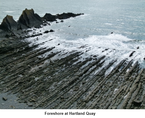
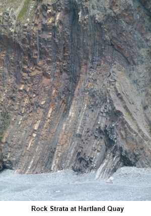
There is interesting
geology to see at Hartland Quay as well as a fascinating museum with lots of
information about local wrecks.
The walk could be combined
with my Hartland Point walk, picking it up from Hartland Quay.
There is a small amount of
road walking to achieve a circular walk but this is on quiet lanes. You are
only likely to meet a few cars on a short section of about half a mile near
the village of Stoke as they pass through to Hartland Quay.
The walk starts in the
village of Hartland where there is a free car park, public toilets and pubs
were you could get a refreshment after the walk although you need to watch
their opening times. There are other opportunities to obtain sustenance at
Hartland Quay or Docton Mill. To get to Hartland, turn off the A39 Bideford
to Bude road on to the B3248 just west of the Clovelly turn.
There are also toilets in,
Stoke, Hartland Quay and Docton Mill (if you visit the gardens).
Start:
From the car park (SS 249245), walk straight ahead passing the Hart Inn
on the right. As you reach the end of 30mph speed limit sign, turn right
down an unmade road – there is a finger post on the right indicating the
way.
Walk along this road to the
British Geological Survey Magnetic Observatory, a fairly non-descript site
but worthy of mention for walkers because its data is used in calculating
the magnetic variation shown on Ordnance Survey maps. The path passes down
the left hand side of the observatory.
This path becomes a broad
track through the trees. Follow this downhill and as it opens into a small
clearing, cross a footbridge and bear left heading for a stile in the corner
(SS 254248). There is a three way finger post.
Cross the stile and keep
straight ahead on the broad main track ignoring any turns off. The track
exits into a road close to the entrance to Hartland Abbey (SS 246248). Turn
left on the road and at the ‘T’ junction, turn right for Stoke.
In Stoke, turn right (SS
236247) at the church then almost immediately
left climbing the second flight of steps to the wide stone stile. Cross it
and walk straight ahead keeping the church on your left. As you exit the
churchyard, at first glance there does not seem to be a footpath straight
ahead but there is, running in front of the row of houses on the right.
Follow this path until it
enters a field then follow the left boundary until you reach a stone cottage
(Rocket Cottage SS 226248). Walk round the right hand side of it and follow
the footpath down to Hartland Quay.
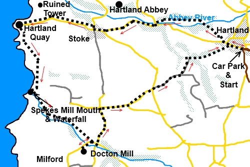
From Hartland
Quay, follow the coastal path designated by the acorn sign in a southerly
direction following the finger post to Spekes Mill Mouth.
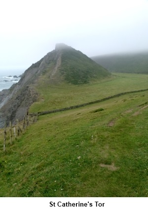
The path passes behind a
large promontory St. Catherine’s Tor. Here, the path splits into three.
Take the middle path heading for the gate in the wall opposite where a
fingerpost indicates the coastal path.
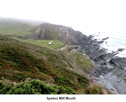
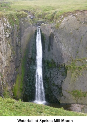
When you reach the impressive waterfall at
Spekes Mill Mouth (SS 225236), after admiring it, turn inland and follow the
broad track to Docton Mill. Ignore the right fork for the coast path and
Welcome Mouth and stay on the main track signposted Lymebridge ¾ mile.
At the next fork, keep
right and pass a bungalow called Appletrees and a footbridge on the right.
At the road junction (SS
225238), turn right to visit Docton Mill (about 250 yards) or otherwise turn
left. At the crossroads with the thatched Spekes Valley Cottage, turn left.
Stay on the road for just under half a mile to the cross roads at Kernstone
Cross. Turn right signposted Stoke and Hartland.
As the road forks, the
right hand fork goes to Hartland but the long way round for a walker. For
the shorter scenic route, fork left.
At the next junction, turn
left signposted Stoke and Hartland Quay and almost immediately right along a
“no through road” (SS 246237) This road may have a sign at its end for
“Leigh farm B & B” (it is a removable sign).
Ignore a farm track on the
right and stay on the tarmac road descending gradually. As the road starts
to rise and bends to Leigh farm, fork left following the fingerpost
“Hartland ½ mile”.
As the track reaches woods,
fork right over the stone stile and on meeting another track very shortly,
turn right and follow it down through the trees.
At the bottom of the slope,
turn right following the fingerpost for Hartland. Keep straight ahead on
this track which emerges into the centre of the village between two large
round gateposts.
If you need to buy any hiking
equipment/clothing before your trip see the Hiking
Store
All information on this
site is given in good faith and no liability is accepted in respect of any
damage, loss or injury which might result from acting on it.
|


.jpg)
.jpg)
.jpg)