|
South
Zeal to Cosdon Hill
|
Starting
point and OS Grid reference:

South
Zeal village (SX 652934) – free car park by the sports field.
|
Ordnance
Survey Map
Ordnance
Survey OL 28 - Dartmoor.
Buy this map from
List
of OS Maps
Note: If you use OS Maps on-line, you can download this route via this
link.
| |
Distance: 7.1 miles
| |
Traffic light rating:


(For explanation see My
Walks page)
| |


For advice on .gpx files see
My
Walks page
|

Click
the PDF logo above to give a printable version of this walk without the
photos.
|
To
view route as a dynamic Ordnance Survey map click here.
Introduction:
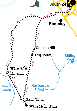
This Dartmoor walk from South Zeal to
Cosdon Hill provides an opportunity to examine some of the relics left by
our Iron Age ancestors, primarily a virtually complete stone circle and an
ancient settlement. Often when these ancient settlements are shown on maps,
it is difficult for the uninitiated to see very much but the evidence is
pretty clear here. The views from the top of Cosdon Hill are great and there
are a number of interesting looking tors around.
Although I set out to follow marked
footpaths/bridleways, because this is Open Access Land and moorland, routes
are not always exactly as shown on the maps but tend to be where most people
have wandered, so the GPS route I have provided is based on the recorded
track of where I actually walked.
The walk starts from a free car park by the
sports field in the very attractive village of South Zeal. To get there,
take the B3260 east from Oakhampton. The car park is only signed to be
noticed by the approach from the Oakhampton end. If you come the other way,
you will miss it. Drive through the village past the small church and stone
cross in the village centre. When the road levels out, look out for the
standard “P” sign on the
right, on the side of a house. Turn right here then right again into the car
park.
Start:
Leave the car park and turn right to walk up the lane. At the fork turn
right and walk to the main road. Cross straight over and up the broad track
opposite. The track bends to the left passing Cawsand House. Also pass a
house “Hillstead” and “Beacon Cottage”. A finger post will point you
to “The Moor”, although its precise direction is a little off.
Stay on the main track and at a ‘T’
junction of broad tracks which are public bridleways, turn left. The track
has been a mixture of concrete and tarmac sections until now but it is now a
stony walled track.
At SX 639930, the stony track enters open
moorland. Continue to follow the track.
%20View%20back%20to%20South%20Zeal.jpg)
After 50 yards or so, the track forks. Keep
right. At the next fork, go left, gradually working away from the wall on
the right. Go left again at the next fork.
It is now difficult to describe the precise
route as there are few landmarks. The track degenerates into more of a
simple moorland path and becomes indistinct in places. To begin with, you
head in the direction of Belstone Tor, the hill with the rocky outcrop,
across the valley in front of you.
%20View%20Across%20to%20Belstone%20Common.jpg)
You come to a little stream which you have to
ford as best you can (very shallow when I crossed). Shortly after the
stream, the path curves left round the base of Cosdon Hill and you start to
run parallel with the Belstone Tor ridge.
At SX 628917 the path forks. Go left. There
is no landmark here except to point out that you are following the right
hand edge of a large, slightly lower area of land.
About half a mile further on, as you begin to
approach the valley of Small Brook, the path forks. Take the left fork. You
now walk through the remains of an Iron Age settlement. Although at first
glance, it just looks like a mass of stones, if you look closely, there are
too many which are standing upright, in a way which would not occur
naturally and you should be able to pick out several circles of stones which
were the sites of the residents’ huts. I actually found one with a couple
of layers of stones at one point, laid like bricks with one stone bridging
the gap between the stones beneath.
%20Hut%20Circle%20at%20White%20Hill%20Settlements.jpg)
The path goes through the settlement and
follows the direction of Small Brook though never gets closer to it than
3/400 feet and gradually climbs the hill to a grassy ridge.
As you get to the top of the ridge at Little
Hound Tor, the stone circle comes into view (SX 633896). Cross a broader
path to view it. 150 to 200 yards south east of the stone circle is White
Moor Stone (SX 634895) which identifies a junction of parish boundaries.
There are other boundary stones and you can see one in the distance north
east of White Moor Stone.
%20Stone%20Circle%20at%20Little%20Hound%20Tor.jpg)
%20White%20Moor%20Stone.jpg)
%20View%20SW%20along%20the%20ridge.jpg)
Return to the broad path bbyt the stone
circle and turn right to follow the ridge to Cosdon Hill. The OS map shows
the location of the trig. point as “Cosdon Beacon” and it is obvious
that because of the superb 360° view, it would have made an ideal spot for
a beacon. There is quite a large stone cairn there too but it looks as
though this and the trig. point sit on top of a much larger mound, which is
probably some much more ancient structure. This looks to have been
“robbed” for the stone to make the cairn and the crude shelter on the
east side.
%20Summit%20of%20Cosdon%20Hill.jpg)
%20One%20view%20from%20Cosdon%20Hill.jpg)
From the trig. point (SX 636915), continue in
the direction in which you approached it, on the clear path (20° magnetic).
There is another smaller cairn marking the path, just before it dips over
the edge of the hill.
%20Panoramic%20shoit%20during%20descent.jpg)
As you descend, the path becomes faint and
uncertain. This is Access Land and people have obviously wandered.
I simply made my way downhill, following tracks here and there (some
might have been sheep tracks) heading roughly for a point midway between the
villages of Sticklepath and South Zeal ahead. I reached a small line of
trees by a stream, leading to the corner of a stone wall. Crossing the
stream and keeping to the left of the wall corner dropped me down to the
stony track used for the outward journey. A right turn and it was a simple
case of retracing my steps to South Zeal.
In practice, whichever way you cone down
Cosdon Hill (as long as it is in a northerly direction!), you will
eventually cross the broader track you used on the outward journey.
If you need to buy any
hiking equipment/clothing before your trip see the Hiking
Store
All information on this
site is given in good faith and no liability is accepted in respect of any
damage, loss or injury which might result from acting on it.
|


.jpg)
.jpg)
.jpg)