|
Salcombe
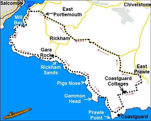
to East Prawle
|
Starting
point and OS Grid reference:

Ferry
jetty at East Portlemouth (SX 743387)
|
Ordnance
Survey Map
OL20
South Devon – Brixham to Newton Ferrers.
Buy this map from
List
of OS Maps
Note: If you use OS Maps on-line, you can download this route via this
link.
| |
Distance: 8.45
miles
| |
Traffic light rating: 

(For explanation see
My
Walks page)
| |


For advice on .gpx files see
My
Walks page
|

Click
the PDF logo above to give a printable version of this walk without the
photos.
|
To
view route as a dynamic Ordnance Survey map click here.
Introduction:
This
is a walk with beautiful coastal views, access to lovely beaches and
probably the finest view of Salcombe itself. To create a circular walk, road
walking is necessary from East Prawle back to East Portlemouth but the roads
are very quiet and there are good views inland towards Dartmoor. The amber
traffic light is marginal but arises because there is a lot of “up and
down” between the mouth of estuary and Prawle Point. No “up” or
“down” is especially long but there are a lot of them!
I
make an assumption that most people would start from Salcombe, using the
ferry because Salcombe is more easily accessible by car and public
transport. You could start from East Portlemouth if you went down the other
side of the “estuary” (actually a “ria” not an estuary but commonly
referred to as an estuary). There is a National Trust car park at Mill Bay.
To
get to Salcombe, take the A381 out of Kingsbridge and keep going! There are
two potential pay and display car parks in Salcombe. One is on Shadycombe
Road which you pass on your way to the other at Gould Road. There is another
on Fore Street but it is tiny, your chances of getting a space there
infinitesimal and by then you will be in the one way system and past all
central car parks. There is free street parking on Devon Road . A copy of
the street map is attached to the PDF document.
%20Ferry%20jetty.jpg)
Start:
For ease of reference, the walk description
starts at the ferry jetty on the East Portlemouth side of the estuary (SX
743387). There is a continuously running ferry during the day from Salcombe
to this jetty but check the ferry times. It is a long way round if you miss
the last one (although water taxis are available). Although I do not
normally give times because everyone walks at different rates, to help
ensure you do not miss the ferry, I will tell you the 3 mile walk from East
Prawle to the ferry took my wife and I 1 hour and 20 minutes at a very
leisurely amble
At
the top of the jetty, turn right following the sign for Mill Bay. Note the
steep steps on the left signed East Portlemouth which are the return route.
At
Mill Bay (SX 742382) where there is a National Trust car park, turn right on
to the coastal footpath signposted “Gara Rock 2½ miles”. On reaching a
fork with a footpath post bearing yellow arrows, bear right and at the next
fork signed “Beach Only” to the right, keep left. The beach in question
is the aptly named Sunny Cove.
%20Salcombe%20Estuary.jpg)
%20Sunny%20Cove.jpg)
On
reaching a bend where there is a bench, ignore the path to the left.
It
is now a case of following the coastal path to the coastguard lookout at
Prawle Point. En route, it is worth the diversion to the old thatched
Rickham Coastguard station above Gara Rock. This was built in 1847 as a
vantage point for the “Preventative Water Guard” who looked out for
smugglers and ships in distress.
%20Rickham%20Sands.jpg)
%20Old%20Coastguard%20Lookout.jpg)
Descend
from here and stay on the coast path (there is a very nice beach here-
Rickham Sands) and another at the lovely Maceley Cove (marked by a footpath
post).
%20Maceley%20Cove.jpg)
%20View%20along%20the%20coast.jpg)
After
passing through an ancient boundary wall of upright stones, the more modern
coastguard station comes into
view (now manned by volunteers – they will show you round if you want a
brief diversion). Head towards this and after the next gate, take the middle
option of the three paths to see the coastguard station, otherwise take the
left path.
Walk
past the old coastguard cottages (SX 774353) to the bottom of the field and
at a gate (without going through it), turn left and follow the tarmac lane
to East Prawle.
%20Coastguard%20cottages%20at%20Prawle%20Point.jpg)
The
centre of East Prawle has public toilets and on the village green is a
general store which has sandwiches/drinks or there is the Pigs Nose pub.
Our
route heads out of the village straight ahead with the public toilets and
phone box on your left. Stay on the “main road” as it bends left and
turn left at the road junction (SX 780365) just after the last house on the
left. At the next road junction, turn left (signed East Portlemouth). On the
horizon, you can see Dartmoor.
%20Salcombe%20from%20East%20Prawle.jpg)
When
you get to East Portlemouth, as the road swings sharp right (SX 746386),
straight ahead is some rough parking and beyond this a tarmac path and steps
take you down to the ferry.
If
you need to buy any hiking equipment/clothing before your trip see the Hiking
Store
All information on this
site is given in good faith and no liability is accepted in respect of any
damage, loss or injury which might result from acting on it.
|


.jpg)
.jpg)
.jpg)