
|
|
|
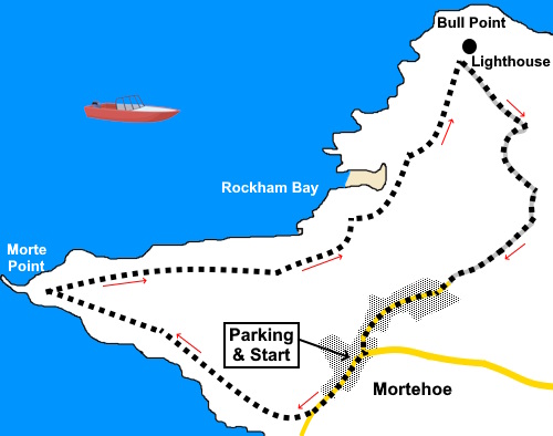
To view route as a dynamic Ordnance Survey map click here. Introduction: This is a lovely walk from the pretty Devon village of Mortehoe to Morte Point and Bull Point. Navigation is a piece of cake as you are either on the clearly signposted Coast Path or on tarmac on the return from Bull Point. On the stretch between Morte Point and Rockham Bay, there is a good chance of seeing seals. Mortehoe village has the attractive St. Mary Magdalene’s church and the Chichester Arms pub. The coastline here has some fearsome rocks which have been the cause of many shipwrecks so it is perhaps with some justification that the name of the village comes from the Latin for “death”! It has also been a centre for smuggling. The kind residents used to lure ships on to the rocks. Once the crews were dead, the wreck then became legally vulnerable to plundering. Nowadays, things are a little more civilised and the village is known for some nice small, local beaches. The famous Woolacombe sands are also nearby. Note
that one of these beaches at Rockham Bay used to be accessible via steps but these have collapsed and been
repaired twice I believe and it looks as though the council have given up! I
do not know if it is possible to scramble down but it is probably a risky
trip! Evidently at low tide, you can see
the remains of the SS Collier which sank in 1914. She was on her way from
Milford to Avonmouth when she ran aground.
She was one of the first steam ships to carry mail to Australia. Bull
Point lighthouse was originally built in 1879 but following a landslip in
1972, there was a partial collapse. Reconstruction was completed in 1974. The walk starts from a large pay and display car park in Mortehoe village. It is not worth trying to park anywhere else. The easiest way to get there is to turn west off the A361 at Mullacott Cross on to the B3343. After about 1¾, turn right for Mortehoe. It is well signposted. Start: Exit the car park and turn left along the road through the village. Pass St. Mary’s church and the old chapel, heading downhill.
Just as the road starts to bend left, turn off right following a fingerpost for “Coast Path” and “Morte Point”, through a gate (SS 455450). Follow the path bearing left to the cliff edge.
As the path starts to level out, there is a fork. Take the right fork.
It soon splits again. This time, take the left hand path to the path nearer the coast. There is a bench here.
Essentially, all you need to do now is follow the Coast Path. Morte Point is unmistakable by reason of the dramatic jagged rocks above the path (see photo).
At SS 459461you pass an attractive cove in Rockham Bay known locally as Mortehoe Beach.
Just after the cove, at SS 459462 there is a sign with the wonderful name “Windy Lag”. Here, the path makes a brief detour inland before curving back closer to the coast. You reach Bull Point lighthouse at its access road. Turn right along this back to Mortehoe.
After about a mile, just after the gate which is the access to the lighthouse, the lane forks. Keep right to return to the village centre. If you need to buy any hiking equipment/clothing before your trip see the Hiking Store All information on this site is given in good faith and no liability is accepted in respect of any damage, loss or injury which might result from acting on it.
| | |||||||||||||||||

.jpg)
.jpg)
.jpg)
%20St%20Marys%20Church%20Mortehoe.jpg)
%20Down%20the%20lane%20in%20Mortehoe.jpg)
%20Wild%20flowers%20by%20the%20footpath.jpg)
%20View%20to%20Morte%20Point.jpg)
%20View%20to%20Woolacombe%20Sands%20and%20Baggy%20Point.jpg)
%20Wild%20flowers%20by%20the%20cliff%20edge.jpg)
%20Sharp%20Rocks%20at%20Morte%20Point.jpg)
%20Morte%20Point.jpg)
%20Onward%20Path%20to%20Bull%20point.jpg)
%20Rockham%20Bay.jpg)
%20Seals%20on%20the%20foreshore.jpg)
%20Rockham%20Beach.jpg)
%20View%20back%20to%20Morte%20Point.jpg)
%20Bull%20Point%20Lighthouse.jpg)