
|
|
|
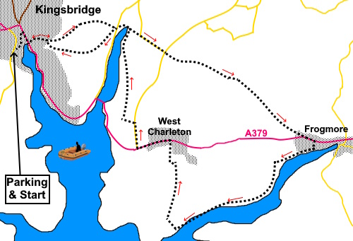
To view route as a dynamic Ordnance Survey map click here. Introduction: This walk from Kingsbridge to Frogmore gives you an opportunity to enjoy some countryside walking with spectacular views and to investigate the waterside footpath alongside Frogmore Creek. It also visits the village of West Charleton with its unusual ‘double tower’ church. The route makes use of an old turnpike road, now a quiet green lane which served as the main route between the towns before the construction of the current main road in the mid 1800s. This involved the construction of a bridge across Bowcombe Creek, across which the A379 travels. This is still known as ‘New Bridge’ although ‘Bowcombe Bridge’ is also used. Note that a small part of the route by the water’s edge is tidal so check the tide times. There does look to be al alternative route which should be ok unless there is an exceptionally high tide. Having done the walk at very low tide, I would say views would be improved at half tide when there would be more water in the estuary. Kingsbridge is an ancient settlement names after a bridge which once stood there and was actually discovered during culvert work in 2026. The ‘King’ part of the name probably arises because the bridge linked royal manors of Alvington and Chillington. The current town of Kingsbridge is actually an amalgamation with an adjacent town Dodbrooke, actually the older settlement and listed in the Domesday Book but it ‘disappeared’ following a merger during late 19th Century local government reforms. Kingsbridge is the main market town in the area and is now popular with tourists thanks to its attractive waterfront. A ferry runs to Salome, according to the tide. It has a mixed industrial past having been known for corn milling, wool production and textiles. The last mill closed in 1965 and the mill was subsequently demolished. Frogmore was a busy industrial port in the 19th Century, handling deliveries of coal, corn, grain, fertilizers, building stone plus limestone for local limekilns. Its name stems from Old English ‘frogga’ and ‘mere’ meaning a mere frequented by frogs. Today the village is much quieter though a bit of a bottleneck for traffic due to its narrow road. West Charleton was an isolated community until the building of the current main road. It relied on agriculture and some quarrying for such prosperity as it had. Today it is popular as a residential village and has an impressive church. This originated in the 15th Century but was extensively restored in the 19th Century. Overall the walk is very straightforward although there are a couple of short steep sections which will make you puff, hence the amber marking! The walk starts from the Cattle Market long stay car park on Ropewalk in Kingsbridge which is cheaper than the Quay waterside car park. To get there, make your way to Kingsbridge. Ropewalk is off Fore Street, by the filling station. Start: Leave the car park via a pedestrian access/egress at the rear left hand corner. This path will take you to a narrow lane where you turn right downhill, passing the sports centre. You will emerge in the Quay long stay car park. Turn left and make your way round the end of the water and then right along the promenade. Turn left up Derby Road and follow it round a sharp right hand bend, passing a pump track and a large house on the left called Overleat. Ignore a footpath sign on the right just after the pump track. Pass and ignore another footpath sign just before a house called Buttville and continue past the house. You soon enter an ancient track, carved out between the rocks. This continues to a three way fingerpost at SX743441. Ignore the left turn and continue along the public byway.
The byway climbs then starts to descend Not far after it starts to descend, turn right over a stile following a public footpath fingerpost (see photo).
Follow the path downhill, passing what I think are old pigsties to arrive at a lane. Cross straight over then aim left about 45° to the road. This will take you to a stone footbridge at the head of Bowcombe Creek (SX 748441).
Once over the bridge, turn right for only fifty yards or so then go left through a walkers’ gate to climb the hill, following the left hand field boundary. The view improves as you climb. At the top of the hill, go through the gate. There is a bench here which you may be grateful for! Join the lane and turn right along it.
The lane
takes you to Duncombe Cross, marked with a road sign. Cross over the lane
and continue down the track at the other side, following the ‘Unmetalled
Road’ sign. You now
follow this route for one mile
ignoring any turns off until you reach a junction where the track turns
sharply left back on itself ( SX 767429). Go right here. You arrive at the main road (A379) in Frogmore. Turn left along it but take care as it is a narrow road. Fortunately it is only for about a hundred and fifty yards or so. Look out for a right turn between two cottages following a public footpath fingerpost for ‘Frogmore Creek 1¼ miles’ and ‘West Charleton 2 miles’. I was a little puzzled by the 1¼ miles to Frogmore Creek but it must depend as to which bit of the creek you are measuring!
Follow the path down to the creek then turn right to follow the shore.
After going through a walkers’ gate the path forks. Follow the left hand fork.
At SX 757416 the path drops down to the beach and you can walk along it. There does appear to be a path marginally inland, which I assume is intended to help if the tide is high. Both lead to the same spot.
Follow
the beach for 350 yards then turn right to follow a public footpath
fingerpost, curving left as you leave the beach. Emerge out of the trees, into a field, passing a bench. Keep straight ahead and then along the tarmac lane.
As the tarmac lane turns right, where there is a ‘beacon’, go through a gate and follow the footpath through the field towards the village.
At
the bottom of the field, turn left, indicated by an arrow on a post. It soon
turns right by another marker and through a kissing gate (SX
754424). It then heads straight up the field to the main road through West
Charleton (A379). Turn left along it. After Sicklemans Close, continue along the section of footpath separated from the road. As you emerge from this, cross the road and turn left briefly before turning right along Church Lane.
Follow Church Lane for just over half a mile and look out for a track on the left opposite a public footpath fingerpost (SX 750 429). Turn along this but Immediately right through a gate then left to follow the left hand field boundary. Very nice views from here over the Kingsbridge Estuary.
At the
end of the field, turn right following the left hand boundary and virtually
at the end of the field, turn left through a kissing gate then bear right
downhill. The path was clear on the ground but if not, the aiming point is a
small copse of trees at the far bottom corner. After crossing a stile and going through a walkers’ gate, you will be back at the stone footbridge you crossed on the outward journey.
Return
to the lane and cross over it but instead of retracing your steps, turn left
at the three way fingerpost. Cross a
stile (basically a big slab of rock across the path) then bear right up the
steep hill. The line of the path is to the nearest power pole. As you get to
this, continue to the corner of the field marked with a post which should be
visible. From here, the path more or less follows the contour of the land,
curving clockwise round the hedged area you can see ahead. Follow
the hedge round to a corner of the field. Cross a stile and follow the right
hand boundary. The path
exits through a walkers’ gate into Kingsbridge RFC car park. Exit down
some steps and cross over its drive and follow the path indicated with a
public footpath fingerpost. The path returns you to Derby Road where you
retrace your steps back to the car park. As an
aside, if you turn left briefly at the promenade, the Crabshell Inn makes
for a pleasant revival! If you need to buy any hiking equipment/clothing before your trip see the Hiking Store All information on this site is given in good faith and no liability is accepted in respect of any damage, loss or injury which might result from acting on it.
| | |||||||||||||||||
.jpg)
.jpg)

.jpg)
.jpg)
.jpg)


%20The%20Old%20Carriageway.jpg)
%20Leaving%20the%20old%20lane.jpg)
%20Old%20Pig%20Pens.jpg)
%20View%20over%20Bowcombe%20CReek%20to%20New%20Bridge.jpg)
%20Pretty%20Cottage%20in%20Frogmore.jpg)
%20Frogmore%20Creek%20at%20Low%20Tide.jpg)
%20Looking%20back%20towards%20Frogmore.jpg)
%20Close%20to%20Kingsbridge%20Estury%20and%20view%20to%20Salcombe.jpg)
%20The%20tidal%20section%20of%20the%20walk.jpg)
%20West%20Charleton.jpg)
%20Old%20beacon%20above%20West%20Charleton.jpg)
%20Church%20of%20St%20Mary%20West%20Charleton.jpg)
%20View%20over%20Kingsbridge%20Estuary.jpg)
%20Wareham%20Point.jpg)
%20View%20Over%20Bowcombe%20Creek.jpg)
%20Reflections%20at%20Bowcombe%20Footbridge.jpg)