|
Hope
Cove to Bantham
|
Starting
point and OS Grid reference:

Pay
and display car park at Hope Cove (Outer Hope)
(SX 676402)
|
Ordnance
Survey Map
OL20
South Devon – Brixham to Newton Ferrers.
Buy this map from
List
of OS Maps
Note: If you use OS Maps on-line, you can download this route via this
link.
| |
Distance: 6.8
miles
| |
Traffic light rating:

(For explanation see My
Walks page)
| |


For advice on .gpx files see
My
Walks page
|

Click
the PDF logo above to give a printable version of this walk without the
photos.
|
To
view route as a dynamic Ordnance Survey map click here.
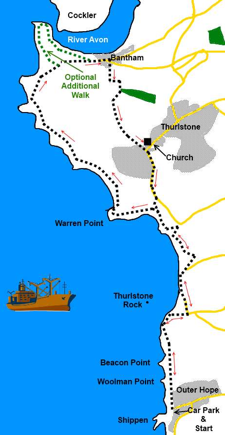
Introduction:
This walk from Hope Cove to Bantham
follows the well marked coast path as it circles around Thurlstone golf
course to Bantham. It passes the water meadows and sand dunes at South
Milton Sands and South Milton Ley, both of which are important nature
reserves. The latter has been designated a Site of Special Scientific
Interest, used as a roost by migrating swallows and by starlings in winter.
Little egrets and stonechats (and others) may also be seen not to mention
the elusive otter – if you are exceptionally lucky!
The walk passes the unusual Thurlstone Rock
with its arch and affords good views across to Burgh Island with its art
deco hotel. As you turn the corner at the mouth of the River Avon, you may
well be entertained by surfers who come here, sometimes in
large numbers, to enjoy the waves.
Hope Cove where the walk starts is most
easily reached by turning west off the A381 at Malborough and on leaving the
village, forking right to Outer Hope. The other part of the village is Inner
Hope but the two are not directly connected by road, though there is a
footpath. The walk starts at the pay and display car park at Outer Hope.
Before starting the walk, it is worth a
wander around the village and its little harbour and especially through to
Inner Hope where there is a picturesque group of thatched cottages.
There are refreshment opportunities en route
in pubs at Thurlstone and Bantham plus a popular beach café at South Milton
Sands and toilets. There are also various benches along the way where you
can enjoy a packed lunch whilst taking in the nice views. There are public
toilets also at Bantham in the car park.
This is an easy walk overall hence the green
traffic light symbols. However there is a short steep climb up a field
shortly after Bantham, guaranteed to make you puff a little!
Start:
Exit the car park (SX 676402) and turn right. As the road bends right, the coast
path, indicated by the acorn sign, goes straight ahead and a public footpath
fingerpost indicates “Bantham 4 miles”.
%20Looking%20back%20to%20Hope%20Cove.jpg)
%20Eddystone%20lighthouse.JPG)
After a few yards, take the steps on the left
and climb to the Hope Cove viewpoint where there is an information board. On
a clear day you can see (with binoculars) the Eddystone Lighthouse and the
stump of Smeaton’s Tower alongside (Smeaton’s Tower is now erected on
Plymouth Hoe). I am usually sceptical about such promised sightings but on
the day I did this walk the murky outline of the lighthouse was visible as
evidenced by the rather poor quality telephoto shot alongside this text. A
dotted line on the information board shows you which way to look.
Continue along the cliff tops and as you
begin to get views of Thurlstone Rock, the path descends slightly turns
inland briefly (SX 676411). On reaching a road, turn left following
the fingerpost for “Thurlstone 1¼ miles”.
The tarmac road peters out to a broad gravel
track at the National Trust property of South Milton Sands where there are
managed water meadows on the right. An information board by the café gives
further information.
Just beyond the café are public toilets.
Turn left here to continue following the coast path. It leads to a long
narrow footbridge at South Milton Lea Nature Reserve. At its far end,
another information board tells you about the Reserve.
%20Thurlstone%20Rock.JPG)
%20view%20across%20thurlstone%20sands.JPG)
On reaching a tarmac lane through a kissing
gate, turn left and follow the lane for 100 yards or so before branching off
left at a right hand bend. After going across a car park, go left to follow
tarmac path. This briefly becomes a metalled lane before the coast path
turns left across the dunes to the obvious route across the cliffs. You are
now on Thurlstone Golf Club territory and, not least for your own safety,
you should stick to the footpath. You will pass a public footpath marker
post for Leas Foot Sand.
Continue to follow the coast path passing
through a kissing gate on to the Evans Estate where a public footpath
fingerpost indicates “Coast Path to Ferry”. Follow its direction, though
we are not taking the ferry.
%20Long%20Stone.JPG)
Here (SX 664437) there is the option to take
the short diversionary route around the little peninsular which juts out
into the River Avon estuary, adding about half a mile to the walk route.
This starts off along sand dunes and is worth the excursion for a look at
Jenkins Quay and its pretty thatched boathouse and the view across the water
of the River Avon to Bantham.
%20Bigbury%20Island.JPG)
%20Jenkins%20Quay.JPG)
If the tide is low, you can see the sandbar
causeway across to Burgh Island and its attractive art deco hotel. To get to
the island, you have to go via Bigbury at the other side of the estuary.
There is a ferry across but it is very limited in operation and I have
excluded its use on this walk.
%20Bantham%20and%20ferry%20Cottage.JPG)
Whether you go via the peninsular or not,
(ignoring the track down to the ferry, other than to see the view) arrive at
and pass through the estate gates. Walk along the main street of the village
and at the Sloop Inn (SX 670437), turn right to follow the footpath along
its left hand side.
%20River%20Avon%20Bantham.JPG)
%20Bantham%20Main%20Street.JPG)
Cross a stile and turn immediately left.
Follow the left boundary of this field as it curves round to a stile by a
gate. Cross it and the path zig-zags right then left and is then clearly
visible up the steep hill, bearing slightly left through the hedge (ignore
the stile on the left immediately after passing the gap in the hedge). There
are good view here back to the estuary and Burgh Island.
The path crosses a broad track between two
large stone gateposts and continues straight ahead. Ignore the footpath on
the right into the golf course. There is a footpath marker for Thurlstone
straight ahead which is your route.
The flat topped spire of Thurlstone’s 12th
Century Church comes into view, on top of which a firepan once served as a
lighthouse. Follow the path to the church and turn right at a broad stony
track behind the church. At a rough cobbled track by the war memorial, turn
left. At the road, our route turns right but before proceeding further, you
might like to turn left for a look at Thurlstone Village with its attractive
thatched cottages and pub.
%20Thurlstone%20Church.JPG)
Stay on the road passing Thurlstone Golf Club
car park and at its far end, cross a stile on the right (SX 674424) and
follow the obvious route back to the coast path where you turn left to
retrace your steps to Hope Cove.
If you need to buy any
hiking equipment/clothing before your trip see the Hiking
Store
All information on this
site is given in good faith and no liability is accepted in respect of any
damage, loss or injury which might result from acting on it.
|


.jpg)
.jpg)
.jpg)