|
High
Willhays and Yes Tor (Dartmoor)
Starting point and OS Grid reference:

Meldon
Reservoir Car Park (Donations box)
|
Ordnance Survey Map
Ordnance
Survey OL 28 - Dartmoor.
Buy this map from
List
of OS Maps
Note: If you use OS Maps on-line, you can download this route via this
link.
| |
Distance: 6.1
miles
|
Date of Walk: 7 August 2013
| |
Ascent:
Descent:
See Walking Time Calculator
|
385m (1264ft)
385m (1264ft)
| |
Traffic
light rating: 

(For explanation see My
Walks page)
| |


For advice on .gpx files see
My Walks page
|

Click
the PDF logo above to give a printable version of this walk without the
photos.
|
To
view route as a dynamic Ordnance Survey map click here.
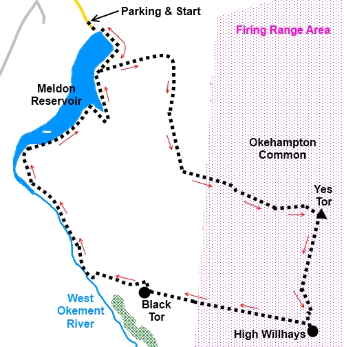
IntroductionThis Dartmoor walk to Yes Tor and High Willhays takes place to a large
extent across the Oakhampton Military Firing Range but do not let this put
you off. Walkers are welcomed when the range is not being used and to avoid
disappointment, a freephone number (0800 458 4868) is available, which has a
recorded message giving availability. Availability can also be checked at https://www.gov.uk/government/publications/dartmoor-firing-programme
For anyone unfamiliar with firing ranges,
they are not awash with unexploded munitions. The army military clear up
after themselves. Obviously if you do exceptionally come across anything
untoward, do not touch it and report it.
Yes Tor was for years thought to be the
highest summit on Dartmoor until piped at the post by its companion High
Willhays, thanks to modern surveying methods. Yes Tor is 2031ft (619m) and
High Willhays is 2037ft (621m). Yes Tor is the one with the trig. point
however.
The walk also follows routes which are
undefined on the OS map. Some is over open ground and although well walked,
feet have not always followed the same paths, so worn routes have not been
created. With that in mind, it is worth remembering that one should not
venture on to open moors without a compass and the knowledge to use it. If
the mist comes down, orientation could become difficult. I have given some
relevant compass bearings.
For those using my GPS route, this is based
on the track recorded automatically as I walked so should be accurate.
The views from Yes Tor and along the ridge to
High Willhays are very good and the West Okement River valley you follow
back to Meldon Reservoir is very pretty.
The walk starts from Meldon Reservoir.
Construction of the dam started in 1970 and was completed in 1972.The
reservoir covers some 57 acres. To get there, take the B3260 south west from
Okehampton. Take the turn off to Meldon and follow the signs for the
reservoir car park.
Start:
From Meldon Reservoir car park, climb the steps next to the toilets and
through the gate turn left to the reservoir dam. Cross this and turn right,
following the broad track by the reservoir.
%20Meldon%20Reservoir.jpg)
The track splits by some picnic tables next
to the water (SX 562913).Take the left fork. The track becomes grassy and
wide and there are shallow vehicle ruts. The track eventually becomes more
stony and bends round to the right.
When the track splits, take the left fork,
walking parallel with the little valley to the left.
At the next fork (SX 568910), go left again.
The path now starts to get very faint and to
the left are the red and white poles which mark the boundary of the
Oakhampton Military Firing Range. Branch off to the left (SX 570905). You
now need to be guided by the large rock close to the top of Yes Tor (see
photo) which will be ahead of you. From where you have branched off, the
compass bearing is 101° magnetic (unadjusted for magnetic variation) to the
summit.
%20Target%20rock.jpg)
There is no clear footpath here just pick the
best route you can. There was the very faint sign of previous passage to
begin with, when I did the walk but I would not guarantee its presence long
term.
As you get closer to the top, there is a
boulder field just before the large rock. Work your way to the right of this
initially until, as you get higher up (from SX 578902), a relatively clearer
route through the boulder field becomes clear. You need to head for the left
hand side of the large rock.
When you get to the large rock, there is a
large pile of stones ahead. Head to the left of these and you will see the
rock outcrops of the Tor proper. Head for these and you will soon catch
sight of the trig. point and a radio aerial.
%20Summit%20of%20Yes%20Tor.jpg)
There are 360° views from the summit.
%20View%20west%20from%20yes%20tor.jpg)
%20View%20East%20from%20Yes%20Tor.jpg)
%20Outcrop%20on%20Yes%20Tor.jpg)
Continue from the trig. point heading
fractionally west of south (205° magnetic) on the obvious track to High
Willhays. There is a large cairn marking its summit.
%20Onward%20route%20to%20High%20Willhays.jpg)
%20Summit%20of%20High%20Willhays.jpg)
For the return from Highwillhays, once again
there is no distinct path. If visibility is clear, you should have no
difficulty in orientating yourself but just in case, head just north of west
(281° magnetic). As you get to the edge of the plateau, you will see three
rocky outcrops below, which overlook the valley with the West Okement River
running through it, which feeds the Meldon Reservoir. Head for the right
hand outcrop which is Black Tor.
%20View%20from%20Black%20Tor.jpg)
Descend to the right of Black Tor to the
riverbank and turn right to follow the path along the right hand riverbank.
%20Looking%20back%20to%20Black%20Tor.jpg)
The path diverts briefly around a walled area
which protects some plant (water abstraction or whatever) but soon returns
to the riverbank.
%20West%20Okement%20River.jpg)
Stay on the right hand side of the river, in
particular ignoring several bridges, until you reach the reservoir, then
simply follow the path round its right hand side back to the car park.
%20Back%20to%20Meldon%20Reservoir.jpg)
If you need to buy any
hiking equipment/clothing before your trip see the Hiking
Store
All information on this
site is given in good faith and no liability is accepted in respect of any
damage, loss or injury which might result from acting on it.
|


.jpg)
.jpg)
.jpg)