|
Hartland
Point and Hartland Quay
|
Starting
point and OS Grid reference:

Hartland
Village Car Park (SS 259245)
|
Ordnance
Survey Map
OS
Explorer Map 126 - Clovelly and Hartland.
Buy this map from
List
of OS Maps
Note: If you use OS Maps on-line, you can download this route via this
link.
| |
Distance: 8.5 miles
| |
Traffic light rating: 
(For explanation see My
Walks page)
| |


For advice on .gpx files see
My
Walks page
|

Click
the PDF logo above to give a printable version of this walk without the
photos.
|
To
view route as a dynamic Ordnance Survey map click here.
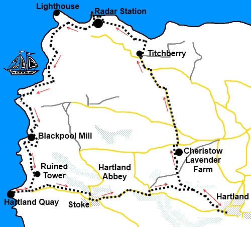
Introduction:
This walk takes you to the most north
westerly corner of Devon with its lighthouse and Hartland quay with a
fascinating little museum. However, the star of the show is the geology of
the cliffs all along the route which show off spectacularly the folded
strata. There is a small amount of road walking to achieve a circular walk
but this is on quiet lanes. You are only likely to meet a few cars on a
short section of about half a mile near the village of Stoke as they pass
through to Hartland Quay.
(Note: This walk could be
extended by using my Spekes Mill Mouth to Docton Mill walk directions from
Hartland Quay onwards.)
The walk starts in the
village of Hartland where there is a free car park, public toilets and pubs
were you could get a refreshment after the walk although you need to watch
their opening times. There are other opportunities to obtain sustenance at
Cheristow Lavender farm, Hartland Point and Hartland Quay. To get to
Hartland, turn off the A39 Bideford to Bude road on to the B3248 just west
of the Clovelly turn.
Start:
From the car park (SS 249245), walk straight ahead passing the Hart Inn
on the right. As you reach the end of 30mph speed limit sign, turn right
down an unmade road – there is a finger post on the right indicating the
way.
Walk along this road to the
British Geological Survey Magnetic Observatory, a fairly non-descript site
but worthy of mention for walkers because its data is used in calculating
the magnetic variation shown on Ordnance Survey maps. The path passes down
the left hand side of the observatory.
This path becomes a broad
track through the trees. Follow this downhill and as it opens into a small
clearing, cross a footbridge and bear left heading for a stile in the
corner. There is a three way finger post.
Cross the stile (SS
254248)and take the footpath climbing ahead through the trees (ignoring the
main track which continues more level). On reaching a field, cross the stile
and follow the hedge on the right. Another stile at the top of the field
takes you into a lane at first bare earth then tarmac.
Follow this lane to
Cheristow Lavender farm (which has a fabulous tea room). Beyond the farm, at
the road ‘T’ junction, turn right then first left signposted Hartland
Point Lighthouse. Stay on this lane ignoring any turns.
After crossing Shamely
Bridge (SS 246268), turn left at the ‘T’ junction.
Just before the National
Trust car park at East Titchberry, turn right (SS 244270), following the
finger post for Coastal Path Bridleway and follow this track past the
thatched farm, a listed 17th century building. Where it forks at
a gate, take the right fork and the narrow footpath straight ahead. This
path emerges on to the coast path above Shipload Bay, with your first
glimpse of dramatic rock strata on the cliffs. Turn left and follow the
fingerpost towards Hartland Point, passing a radar station.
%20Shipload%20Bay.jpg)
%20Approaching%20Hartland%20Point.jpg)
At Hartland Point car park
(where there is a refreshment kiosk), take the footpath heading towards the
radio mast and coastguard station, turning left just in front of it,
although it is worth making the short diversion to the viewpoint on the far
side first for good views of the
lighthouse built in 1874 and the remains of the ship Johanna which ran
aground on 31 December 1982.
%20Hartland%20Point%20and%20Lighthouse.jpg)
%20Remains%20of%20the%20Johanna.jpg)
Continuing the coast path
you pass a monument (SS 230274) to the Glenart Castle hospital ship which
was torpedoed by the Germans in World War I on 26 February 1918.
The path descends to a
brook and as it does, you will see steps climbing the other side which is
your continued route. Stay on the coast path ignoring the left turn
indicated by a public footpath finger post.
%20Bay%20at%20Blackpool%20Mill.jpg)
%20Rock%20Strata.jpg)
The path descends to Gull
rock, climbs again then descends to Blackpool Mill (SS 227257). Here, it
turns briefly inland on a broad track before turning right just after the
cottage.
As you climb to the top of
the rise, ignore the small track to the right. The path forks but both legs
meet up shortly.
The tall tower of Stoke
church appears to the left and the ruins of an old tower ahead. Inland, you
can see the village of Hartland.
%20Tower.jpg)
%20Close%20up%20of%20Rock%20Strata%20at%20Hartland%20Quay.jpg)
As you approach the stone
cottage Rocket House, turn right and follow the path down to Hartland Quay
(SS 223248). The Hartland Quay Hotel provides yet another pit stop
opportunity. Please do not miss the museum accessed through the shop which
has a fascinating wealth of information about shipwrecks in the area. Also
visit the quay itself for sight of some remarkable rock strata. There are
toilets.
%20Bay%20at%20Hartland%20Quay.jpg)
Retrace your steps to
Rocket House and turn left just before it. Walk round the back and then
follow the hedge on the right hand edge of the field parallel with the road.
The path crosses two fields with a stone stile between them then as it is
about to exit into the road, note the separate footpath which goes in front
of the houses to reduce road walking. Follow this straight through
the churchyard with the church on the right and after stepping over an
unusual broad stile, go down the steps to the road. Be
careful here as it is quite easy to step into the path of any vehicles using
the road.
Turn right and at the
‘T’ junction, turn left.
Follow the road through
Stoke village (there are toilets in Stoke) heading towards Hartland. You
could just stay on the road but if you wish to minimise the road element,
turn left when you reach the road, signposted “Berry 1 mile” and
“Hartland Point Lighthouse 4 miles”.
After 100 yards, turn right
off the road where there is a green fingerpost sign. As it forks, go left
and follow it along until it joins the route where you began your journey.
Turn right at the gate and retrace your steps to Hartland.
If you need to buy any hiking
equipment/clothing before your trip see the Hiking
Store
All information on this
site is given in good faith and no liability is accepted in respect of any
damage, loss or injury which might result from acting on it.
|


.jpg)
.jpg)
.jpg)