|
Brownsham
to Clovelly
|
Starting
point and OS Grid reference:

National
Trust car park at Brownsham (SS
285260)
|
Ordnance
Survey Map
OS
Explorer Map 126 - Clovelly and Hartland.
Buy this map from
List
of OS Maps
Note: If you use OS Maps on-line, you can download this route via this
link.
| |
Distance: 6
miles
| |
Traffic light rating: 
(For explanation see My
Walks page)
| |


For advice on .gpx files see
My
Walks page
|

Click
the PDF logo above to give a printable version of this walk without the
photos.
|
To
view route as a dynamic Ordnance Survey map click here.
Introduction:
This is a very easy walk which shows
off a short section of the North Devon coast and the picturesque village of
Clovelly.The island of Lundy is clearly visible about 12 miles out to sea
but it looks closer. The main street in Clovelly is very steep and barred to
traffic and locals use sled contraptions to haul supplies to their houses
from the parking area at the top. There are public toilets in Clovelly and
refreshments aplenty. I chose the Red Lion Hotel down by the harbour which
was fine. An advantage of approaching Clovelly this way at busy times is
that you avoid the mayhem and cost of the tourist car park!
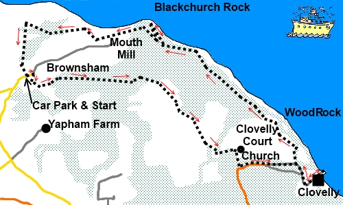
The walk starts from the National Trust car park at the hamlet of
Brownsham (SS 285260) To get there, turn north off the A39 Bideford to
Kilhampton road on to the B3248 to Hartland. After about one and a half
miles, on a bend, turn right following the small white on black sign for
Lundy Heliport. At the first junction, keep straight ahead for Hartland
Point and Lighthouse. At the next two junctions, follow the signs to
Brownsham. The National Trust car park is clearly marked.
Start:
Leave the car park on to
the road and turn left. Walk down the road and take the bridleway on the
right following the direction of
the fingerpost Mouthmill I mile.
At a fork, where the right hand fork is gated, keep left. Follow the clear
stony track down the hill ignoring any turns off, until you reach another
fork. The left fork goes to Mouthmill Bay but go right following the public
bridleway sign.
At another junction a few
yards further on, turn left, again following the public bridleway sign.
After about 100yards, fork right indicated by another public bridleway sign.
At a gate, the track goes
straight on – there is a blue public bridleway arrow. Go through another
gate and the route crosses the middle of an open field. Follow this to the
far right hand corner form where the track follows the line of the trees (SS
303256).
%20Clovelly%20bay.jpg)
As the track descends to
Court Farm, you start to get views of Clovelly Bay to the left. The track
passes between the farmhouse on the left and the lovely thatched Dairy
Cottage on the right before becoming a tarmac road. Stay on this, ignoring
any minor turns off and when it forks at a bend, go right and exit into the
road through the impressive estate gates (SS 309250). Follow the road down
towards Clovelly.
You will arrive at a fork,
the right leg being signed “All vehicles for Clovelly”. Go left and note
the finger post here indicating the coastal path left (SS 316250). This is
where you resume the walk after visiting the village. It is worth a walk
down to the harbour at the bottom and the Fishermens’ Chapel off the right
of the main street is interesting.
%20Cobbled%20street%20at%20Clovelly.jpg)
%20Fishermens%20Chapel.jpg)
%20Cottages%20at%20Clovelly.jpg)
%20Clovelly%20Harbour.jpg)
Return to the coastal path
finger post mentioned above and follow the coastal path through a large
wooden gate. Keep right at two forks in the path, following the coastal
path, going through a kissing gate and passing a stone shelter.
%20Angels%20Wings%20shelter.jpg)
%20View%20to%20Blackchurch%20Rock.jpg)
Stay on the coast path
ignoring a footpath to the church. You soon come to an unusual shelter
called the Angels Wings with carved wooden supports, built in 1826 (restored
1934).
At the junction with a
broad track, keep right following the coastal path fingerpost and shortly
afterwards, the path opens on to open land with good views along the coast,
inland across rolling countryside and of Lundy Island.
At SS 302263, the coastal
path turns left and then immediately right but here there is also a
permissive path to a viewpoint for Blackchurch Rock which is worth a
diversion. The distance is given as ½ mile but it does not seem as far as
this. There is an impressive Grade II listed summerhouse there built in 1820
by Dame Diana Hamlyn (SS 299266).
%20Beach%20at%20Mouthmill%20Bay.jpg)
Returning to the coastal
path, follow it to Mouthmill Bay where you descend to the stream. The
footpath climbs at the other side but before continuing, it is worth
crossing the pebble beach for another view of Blackchurch Rock. There is an
old limekiln at this beach.
%20Limekiln%20at%20Mouthmill%20Beach.jpg)
%20Blackchurch%20Rock.jpg)
Just past the limekiln and
after passing another old building, the coastal path is on the right. Shortly
after climbing a flight of stairs, enter the National Trust land of Brownsham. Turn right
along the field. Climb some wooden steps and go through a walkers’ gate.
Follow the path in the direction of the sign Windbury Point 1¼ miles, round
the field with the hedge on the right.
At the end of the field
through a walkers’ gate is a three way fingerpost. Go left – Brownsham ½
Mile.
Cross another stile and go
across two fields before another stile leads you down a narrow footpath.
Descend through the trees until you reach another three way fingerpost and
take the left path to Brownsham. A final fingerpost indicating Brownsham Car
Park takes you back to your starting point.
If
you need to buy any hiking equipment/clothing before your trip see the Hiking
Store
All information on this
site is given in good faith and no liability is accepted in respect of any
damage, loss or injury which might result from acting on it.
|


.jpg)
.jpg)
.jpg)