
|
|
|
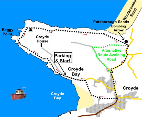
To view route as a dynamic Ordnance Survey map click here. Introduction: This is an easy circular walk from Croyde to Baggy point. The path to the point is broad and well manicured and can be accessed by wheelchairs etc. Baggy Point is a dramatic headland owned by the National Trust. It has Croyde Bay on one side and Woolacombe and Putsborough sands on the other, which were used as simulation to practice the Normandy landings during World War II (WW II). It has been designated as an Area of Outstanding Natural Beauty as well as a Site of Special Scientific Interest, by reason of important botanicals and geology. A variety of seabirds can be seen and seals often swim around the point. Shortly after the start of the walk you pass the bones of a large whale washed up on Croyde Beach in 1915. Baggy Point Pond; a former garden pond left to the National Trust by the Hyde family and now restored to provide a wildlife habitat. At the end of the cliff path, you reach a small building alongside which is a large concrete arrow set into the ground. This was part of a practice bombing range for the RAF in WW II. A target was moored in the bay and the arrow served to guide the bombers in the right direction. An information board gives full details. Croyde,
through which the route passes towards its end is now a fairly typical,
small seaside resort, though some occupation has been here since prehistoric
times. Its name may come from a Viking Crydda. The route leaves Croyde alongside
the Billy Buds pub, where I recall enjoying a decent pint in their outside
area. The walk starts from the Baggy
Point National Trust car park (SS
4323 3969). To get there, I recommend approaching Croyde via the A361 from
Barnstable or Ilfracombe. Turn on to the B3231 at Saunton, following the
sign for Croyde. Follow this until you see a brown tourist sign indicating a
turn to Baggy Point. Follow this until you reach the NT car park, on the
right. Beware
blindly following a sat. nav. as some of the cross country roads are the
narrowest you are ever likely to meet! On the subject of narrow roads, in hindsight, I made a mistake following the road back to Croyde at the end of this route, expecting a quiet lane. It is a very narrow road and it seemed exceptionally busy with traffic, including coaches/vans, which meant various ‘squeezings’ into the hedge. If I was doing the walk again, from the concrete arrow, I would take another footpath westwards to join a track at SS 439404. Turn left here then join the road at SS 443398. This adds half a mile or so to the overall distance but will be less fraught. I have indicated this alternative route on the sketch map. Start: Exit the car park and turn right along the road which eventually becomes a broad track. Just as the path bends left, there are some steps on the right leading to Baggy Point Pond and an information board. Go through a gate signposted “National Trust Baggy Point”, where the path branches up the hill but for the point, remain on the left hand path.
The point itself is fairly obvious and you can walk out to the rocky part at the end. Return to the Coast Path and climb the steps. At the top, take the right fork heading towards a two way fingerpost which should be visible.
At the fingerpost, turn left following the coast path. At SS
422407, you come to the Baggy Point Coastguard Pole. An information panel
explains its purpose, namely to provide a simulated ship’s mast to enable
practicing rescues by breeches buoy.
Shortly
after this is a magnificently sited bench with a view, should you fancy a
picnic.
Arrive at a three way fingerpost by a bench. The right turn will take you back to the National Trust parking if you want to shorten the walk but otherwise, continue following the coast path. You come to another three way fingerpost at SS 438407. Keep straight ahead following “Woolacombe 3 miles”.
As you reach the area above he caravan site, the path divides. It will take you down to the beach if you want a paddle otherwise, keep straight ahead to the right of a small grey building (SS 447406), connected to the wartime activities of Putsborough’s aerial bombing range
The path exits through a walkers’ gate into a lane. Turn right. At the junction with the road, turn right. You now need to take extreme care as this road is narrow and can be quite busy. At the next road junction, turn right for Croyde. In Croyde, pass the shops and look out for a lane on the right, alongside the Billy Buds pub with a “To the Beach, Public Footpath” sign. Turn right. The lane becomes a rougher track. Follow it until you get to a gate and through this, bear right to the opposite corner of the field There are two paths here. Take the right hand option. The path takes you through a site of holiday cabins to the road. Turn left to return to the car park. If you need to buy any hiking equipment/clothing before your trip see the Hiking Store All information on this site is given in good faith and no liability is accepted in respect of any damage, loss or injury which might result from acting on it.
| | |||||||||||||||||

.jpg)
.jpg)
.jpg)
%20View%20over%20Croyde%20Bay.jpg)
%20Well%20manicured%20path%20near%20the%20start%20of%20the%20walk..jpg)
%20Baggy%20Point%20Pond.jpg)
%20View%20back%20to%20Croyde%20Bay.jpg)
%20Cliffs%20at%20Baggy%20Point.jpg)
%20Baggy%20Point.jpg)
%20More%20cliffs%20at%20Baggy%20Point.jpg)
%20Baggy%20Point%20Coastguard%20Pole.jpg)
%20Bench%20with%20a%20view.jpg)
%20Putsborough%20and%20Woolacombe%20sand.jpg)
%20Concrete%20aiming%20arrow%20for%20pilots..jpg)