
|
|
|
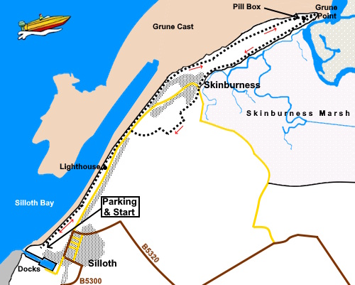
To view route as a dynamic Ordnance Survey map click here. Introduction: This walk was prompted by my studying a map of the Solway Firth and wondering what it was like at the end of the ‘prom’ at Silloth and on to Grune Point. Not wanting to simply walk there and back, I worked out a partly circular route which you can see from the map. It was a very easy virtually dead flat walk. I started in Silloth from the main car park but there are two or three alternative car parks along the promenade if you wanted to shorten it. Silloth is quite a lovely little place. Not a great deal going on but it was remarkably well kept and free of litter and graffiti, which shame many seaside towns. It developed from a small hamlet in the mid nineteenth century, after a port was established. A railway was built (closed 1964) and it became a popular seaside resort, especially for day trippers. Steamer services went to Dublin, Liverpool and the Isle of Man. Salt making, chemical manufacture and mineral water provided trade for the port and in 1887 Carrs flour mill was established and still operates today. The port area is not accessible by the general public. Silloth has a huge, substantial concrete promenade/sea wall stretching for almost 2 miles with lots of groynes protruding into the sea to contain drift of the sand/shingle. This does not make for desperately interesting walking but it is backed by an equally long grassy area on which you can walk, to avoid the concrete. On this grass is the most northerly lighthouse in England, built on a lattice structure. It was built in the 1850s. Grune Point is a local landmark protruding into the Solway Firth and river estuaries area of the Eden, Wampool and Waver. Its main claim to fame is a peculiar WW2 pill-box constructed with concrete filled sandbags, which have long since rotted away. This method of construction is supposedly unique to the area and known as a ‘Cumberland Machine-Gun and Anti-Tank Rifle Emplacement’. On its top sits a cairn in memory of four Silloth Firemen who, responding to a false alarm about someone stranded on the marshes in 1956, drowned when (it is believed) their open boat was swamped. The pill-box has a supporting pillar in the centre which I have never seen before in a pill-box. Grune Point is also well known for its variety of flora and fauna including natterjack toads. It is quite entertaining to sit at the point and watch the sea slowly submerge the sand/mud flat landscape. Do not venture out on to this area! Also keep an eye on water levels/high tide times, though I think it would have to be a peculiarly high tide to pose a problem, as long as you stick to the higher grassy areas. There are supposed to be the remains of a plane which crashes during WW2 visible at low tide though I did not spot it and the tide looked pretty low. The return journey is on the opposite side of the point via Skinburness, a small hamlet with the ruin of Marsh House, which I think would have been quite impressive until it was mostly destroyed by fire in 2020. On
the return journey, I did encounter a badly overgrown stile/bridge. This has
clearly been badly neglected by whoever is responsible for its maintenance.
I reported it to Cumberland
Council on 21 August 2025 (Ref. EI/255695)and
they have replied indicating a contractor will attend and repair the
stile/bridge. If anyone finds it is sorted,
please let me know so that I can delete this note. If it has not been,
please report it again with a photo. Silloth is on the B5300 Cumbria coast road, above Maryport. To get there, follow the road into Silloth. At the cross roads in the centre, continue straight ahead to the left of the park. Car parking and start is at the end by the lifeboat station or there is plenty of on street parking. There are also other car parks along the promenade. Start: From the main car park, join the promenade and turn right along it or if preferred you can walk along the grassy area next to it. You will soon pass the lighthouse.
Follow the promenade to its end where there is a slipway. As you walk along, keep a lookout for a three way fingerpost after a couple of bungalows showing “English Coast Path” in your direction and “Public Footpath” to the right. This marks your return path.
Beyond the slipway, the route continues as a rougher footpath between large boulders and the backs of private gardens.
At NY 127561 there is a three way fingerpost indicating the English Coast Path you are following turns right. Ignore the public footpath sign which looks as though it just goes to the beach and continue to follow the coastline. NY 140567 is a two way fingerpost directing you right for the English Coast Path however for Grune Point, you need to follow the clear path straight ahead. There was a sign indicating a request to turn right, to protect nesting birds but the path looked too well used for there to be any danger of birds nesting on it. There was no sign of any nests.
The pill box is soon obvious with its cairn on top and just beyond is the extremity of the point itself.
The return journey is simply a case of coming down the opposite side of the point, this time keeping the sea area on your left. You will soon come across a fingerpost picking up the English Coast Path from the one at NY 140567 mentioned above. Continue along the coast. The path can be a little sparse in places but eventually becomes a wide track. Just after you get back to the houses, there is a three way fingerpost. Continue to follow the English Coast Path sign, along by the houses. You arrive at the attractive hamlet of Skinburness. When the road bends left keep straight ahead, past the entrance to the caravan site.
The track ends at a field (NY 125555). Here you need to turn through the gate on the left and follow the right hand boundary. At
the first corner you come to (NY
126554), turn right along a long narrow field, following the right hand
boundary once more. In the far right hand corner cross a plank bridge over a stream with a stile at each end. This is the obstructed stile I referred to in the introduction. I got through it but it was not easy! Once over is, turn right, again following the right hand boundary.
As you enter the next field, turn left and follow the left hand boundary, curving right. In the far left hand corner of that field, exit into the lane and turn right to return to the ‘prom’, then follow it to the left back to the parking. If you need to buy any hiking equipment/clothing before your trip see the Hiking Store Add Adsense Code! All information on this site is given in good faith and no liability is accepted in respect of any damage, loss or injury which might result from acting on it.
| | |||||||||||||||||

.jpg)
.jpg)
.jpg)
%20Start%20of%20the%20walk%20to%20Grune%20point.jpg)
%20Lighthouse%20at%20Silloth.jpg)
%20Furtrher%20along%20the%20prom.jpg)
%20Slipway%20at%20the%20end%20of%20the%20promenade.jpg)
%20Evening%20primrose%20by%20the%20path.jpg)
%20Wild%20Rose%20&%20hip.jpg)
%20Path%20beyond%20the%20promenade.jpg)
%20Looking%20across%20Silloth%20Bay%20to%20Scotland%20&%20broken%20sea%20defences.jpg)
%20Grune%20Point%20pill%20box%20and%20cairn.jpg)
%20Entrance%20to%20pill%20box.jpg)
%20Supporting%20pillar%20inside%20pill%20box.jpg)
%20Looking%20across%20the%20river%20Wampool%20estuary.jpg)
%20View%20over%20river%20Waver%20estuary.jpg)
%20Ruin%20of%20Marsh%20House.jpg)
%20Skinburness.jpg)
%20Blocked%20stile.jpg)