
|
|
|
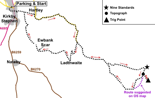
To view route as a dynamic Ordnance Survey map click here. Introduction: Nine Standards Rigg is at the summit of Hartley Fell, in Cumbria at 2,172 ft (662m). The views from here are superb towards the Lake District and Cross Fell area, as well as to the Yorkshire Dales. It is on the Coast to Coast route. The name derives from the “Nine Standards”, nine curious stone cairns which are perched on the summit, some about 12ft high. No-one really knows their purpose. Suppositions suggest boundary markers or Roman structures to scare the Scots, though why stone cairns would frighten anyone, I do not know. What is more certain is that they have been there a very long time, having been mentioned in 17C documents at least. They do receive “maintenance” so at least one of them looked pretty pristine when I visited, belying its actual age. Further along the ridge is a topograph, erected to commemorate the marriage of Prince Charles and Lady Diana. Slightly further is the trig. point itself though views are better from the Nine Standards. One could return by the same route initially, though I chose a somewhat boggy circle to vary things. However, it is well worth taking the route via Ewbank Scar. This takes you through delightful woodland past this impressive limestone edifice. Overall, this is a fairly easy walk with a moderate ascent to the summit. There is some road walking but this is on a dead end road and so with little traffic. The walk starts from a free car park off the unusually named street of Christian Head (continuation of Silver Street) in the market town of Kirkby Stephen. Kirkby Stephen is on the A685. Turn west off the A685 at a roundabout in the town centre, along Silver Street. There are no facilities along the route after leaving Kirkby Stephen but some useful shelters at the summit for a picnic. Start: From the car park (NY 773088), head for the town centre, via a footpath which is signposted. Cross a road and down the footpath opposite to the market square. At the market square, keep straight ahead, passing the Cloisters (the building with the pillars). Follow the sign for the River Eden and Franks Bridge on the wall opposite the public toilets.
Cross Franks Bridge over the Eden, allegedly named after one Francis Birbeck, a brewer. Turn right to follow the “Coast To Coast” fingerpost. Keep straight ahead at a three way fingerpost but note the turn to the right to “Pod Gill” is the return path. In the corner of the field, go through the gate, ignoring the right turn to Nateby. You arrive at the pretty hamlet of Hartley. Turn right here and walk along the road. After a few yards, branch off left following the sign for “Coast to Coast” and “Nine Standards”. Cross the river and turn right. When the road bends, take the footpath in the corner (this just cuts out a bit of road walking). On rejoining the road, turn right.
Follow the road, crossing a cattle grid where you are reminded by a sign that the verges are private land. You also pass a large quarry. It is necessary to follow the road for about a mile and a half but it is a dead end so there is virtually no traffic. As you climb, the views open up.
When you reach the end of the tarmac, the track splits (NY 799075). Follow the public footpath fingerpost “Public Bridleway to Rollinson Haggs”. Note you will follow the public footpath to the right to “Ladthwaite” (see * below), on your return route.
A few yards further on, the track splits again. Keep right. The broad track comes to an end by a ruined barn and a sheep pen. Keep straight ahead to the left of the wall up the hill. At NY 811067 fork left, following the fingerpost for “Permissive Path C to C” and continue up the clear footpath to the Nine Standards. There are some seat shelters on the way where you can stop for sandwiches, although much depends on which way the wind is blowing. At the top, at the other side of the Nine Standards, there is a crude shelter with more chance of getting out of the wind with flat stones to sit on.
From the Nine Standards make your way along the summit to the topograph (right in relation to your approach up the hill from Kirkby Stephen or 189° magnetic). As you get to it, note the path forking right, which is your onward route but to “conquer” the trig. point, continue along the ridge on the obvious path.
Back to the topograph and turn left on the path mentioned above. When I did this walk, there was a lot of boggy ground on the descent from the ridge and to avoid this, I deviated from the official footpath route. This is Access land, so a deviation is in order. The Memory Map/GPX route is the track of the way I actually went. However, without this tool, if you lose the path, descend in a roughly SW direction and you will eventually intersect with a clearer path. Turn right along this. You come to a crossroads of paths where there is a fingerpost. Keep straight ahead following the fingerpost for “Coast to Coast”. Remain on the path until you meet the *fingerpost you encountered on the ascent. Turn left for “Ladthwaite”. Follow the track as it curves right. Cross a cattle grid and a few yards further on as the main track bends right, turn left on a stony track, which is clear at first, then peters out into grassland. There is a fairly new plantation of trees here. I continued along the top of the banking to the end of the plantation end then turned sharp right to circle clockwise round it. About half way along the bottom of the plantation, turn left to follow a diagonal path which meets with the broad track in the valley bottom. Note the path on the OS map appears to drop down a much steeper part of the bank but judging from the worn turf, convention follows the way I describe. At the broad track in the valley bottom, turn left. Just before the cottages at Ladthwaite, turn right to follow on of four fingerposts to “Ewbank Scar” and “Kirkby Stephen”.
After fifty yards or so, go left over a concrete bridge then immediately right. After crossing the flat field by the stream, go over a stile and climb the small hill beyond, before descending again to follow the course of the stream. As the stream bends sharply right, follow the path, up a banking, to a stile. Over the stile turn right. Here there are two paths, one lower nearer the stream and one higher up. I opted for the higher path which provides better long distance views. The path descends to a farm gate. Go through this then take the stile on the right, followed by a two plank footbridge. There is a butterfly symbol on a post, just before the bridge. The path (# See Footnote) goes through a lovely woodland which was carpeted with bluebells and wild garlic when I did the walk. Ewbank Scar is an impressive limestone cliff with Ladthwaite Beck cascading along its base. Evidently it was a favourite Victorian beauty spot. The trees can make it awkward to get a good view.
At the end of the woods, the path curves left up some old stone steps, then right to a stile. Cross the stile and turn right following the yellow footpath arrow. There are views along here of the Podgill Viaduct.
The route is now easy to follow over a series of stiles ending at a brick-built bridge. Cross this and follow the right hand boundary of the field. At the end of the field, turn right through a gate (or cross the stile next to it), then turn right through the trees. Cross a footbridge then follow the river. You arrive at a tarmac path, part of the outward journey. Turn left and retrace your steps to Kirkby Stephen. #
Footnote: On
11 May 2018 information was received to say that the footpath at Ewbank Scar
had been lost in floods but that walkers had created an alternative route
(though not strictly a Right of Way). If anyone gets more up to date
information, or if the footpath proper is discovered to have been
reinstated, it would be appreciated if this site could be informed. If you need to buy any hiking equipment/clothing before your trip see the Hiking Store All information on this site is given in good faith and no liability is accepted in respect of any damage, loss or injury which might result from acting on it.
| | |||||||||||||||||

.jpg)
.jpg)
.jpg)
%20Franks%20Bridge.jpg)
%20View%20from%20road%20above%20Hartley.jpg)
%20Wild%20boar%20fell.jpg)
%20Another%20view%20from%20road%20above%20Hartley.jpg)
%20View%20towards%20Howgill%20Fells.jpg)
%20Nateby%20Common.jpg)
%20Dukerdale.jpg)
%20View%20towards%20the%20lake%20District.jpg)
%20Nine%20Standards.jpg)
%20Largest%20of%20the%20Nine%20Standards.jpg)
%20View%20to%20Yorkshire%20dales.jpg)
%20View%20from%20topograph.jpg)
%20Nine%20Standards%20Rigg%20Trig%20Point.jpg)
%20View%20near%20Ladthwaite.jpg)
%20Ewbank%20Scar.jpg)
%20Podgill%20Viaduct.jpg)