
|
|
|
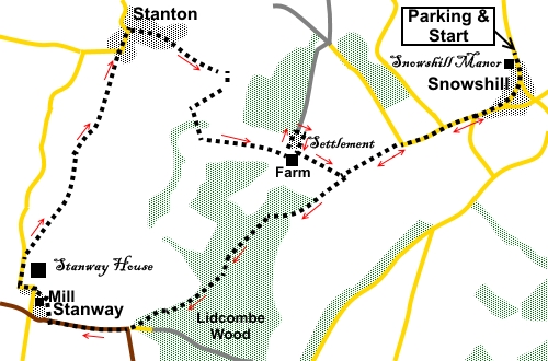
To view route as a dynamic Ordnance Survey map click here. Introduction: The Cotswold’s trademark, is the selection of pretty towns and villages with their honey coloured stone. There are the well known honey-pots such as Bourton-on-the-Water and The Slaughters, where you are likely to trip over Far Eastern tourists, there are so many. On the other hand, there are quiet, relatively undiscovered villages which are equally pretty, with thatched cottages and roses. This walk visits three of them. The walk begins at Snowshill whose main claim to fame is Snowshill Manor, a National Trust property containing an eclectic mix of objects collected by one Charles Paget Wade in the first half of the 20th Century. The manor is pretty much as he left it and the gardens are lovely. It is well worth a visit, though probably not the same day as doing this walk! A cross country trek takes you to Stanway, a village dominated by Stanway House, a large Jacobean Manor open to the public on certain days. It was closed when I passed and it is none too visible from the route, other than an occasional glance. However, if its entrance gates are anything to go by, it will be pretty impressive. Next door is St Peter’s Church and Stanway Watermill. The mill is also open certain days. It is fully restored and works! I mentioned in the opening paragraph about thatched cottages and roses, well, in Stanton, this applies to the village cricket pavilion too! The last village on the round is the gorgeous Stanton, with a long history, well over 1,000 years. Its church has a very tall spire. At the top of the village, The Mount Inn offers a refreshment opportunity or if you are picnicking, there are benches in the village and the churchyard. After the village, the route climbs Shenberrow Hill, crossing the site of Shenberrow Hill Fort, a Scheduled Ancient Monument but evidence is thin on the ground for the uninitiated. However it would certainly have commanded a good defensive position. There are useful benches in Stanton village, including the churchyard, where you can perch for a picnic. The walk starts from the free car park next to the National Trust car park for Snowshill Manor. Snowshill is most easily located from the top of the High Street in Broadway which is on the A44 between Evesham and Stow-on-the-Wolds. Follow the brown tourist sign for the National Trust’s Snowshill Manor and you will easily find the adjacent car park. You could of course start at any of the villages mentioned as this is a circular walk. Start: Leave the car park (SP 097341) and turn right along the road through the village, passing Snowshill Manor (look over the wall for the best view), the Snowshill Arms and St Barnabus Church.
Continue along the road and just outside the village, turn right up a no-through road signposted to Ashwood House, Sheepscombe House and Shenberrow Farm, plus a fingerpost for the Winchcombe Way (SP 094336). Continue along this road, ignoring a road off to the right and a bridleway off to the left. Behind you on the far hill, you can see Broadway Tower.
As the road bends right, turn off to follow the public bridleway “Winchcombe Way” sign (SP 088334). Once through the gateway, follow the fence on the right. At the top of the field, go through an opening into the next, following the yellow footpath arrow for the “Winchcombe Way”, to the opposite corner of the field. Here, turn left along a broad track indicated by a fingerpost for “Restricted Byway Winchcombe Way”. After no more than fifty yards, turn right through the second entrance, to the left of a power pole (SP 084331). At the end of the field, go through a gate and join a broad track, turning right to follow a blue bridleway arrow, down the left hand side of the trees (not the track going into the trees). Just before reaching a barn, fork right into Lidcombe Wood, following another blue bridleway arrow. After a few yards, the track forks, take the right hand fork, descending through the trees. Just before leaving the trees at a gateway, the track forks. Take the left fork, climbing slightly, following the blue bridleway arrow. Views start to open up to the right.
When the track divides (SP 071322), take the more minor path off to the right, emerging at a barn and cottage. Turn right and drop down to the main road (B4077). Turn right along the road. This is a busy stretch, not particularly pleasant to walk along but there is a pavement and you follow it for less than half a mile. Just before the road turn for Stanton, turn right indicated be a public footpath fingerpost for the “Cotswold Way” and “Stanway ½ mile” (SP 062321). When the path splits, keep right following the yellow arrow. Pass Stanway Watermill, then turn right along the road.
Stay on the road as it curves left past the imposing entrance to Stanway House and the church, then curves right.
As you draw level with the cute thatched cricket pavilion to the left, turn right to follow a public footpath fingerpost for the “Cotswold Way” and “Stanton 1¼ miles” (SP 060325). The now well trodden and waymarked path takes you to Stanton and as you enter a narrow section of path, the church spire is ahead.
Join the drive to a house through a walkers’ gate. Follow this to the road and turn right.
Continue through the village on the main street and as the road bends left (the way to the pub!), turn right following the road marked “Unsuitable For Coaches”. At the next fork, go right, indicated by the Cotswold Way fingerpost. The track opens into what looks like a rough parking area. Turn right here, following a yellow public footpath arrow. The path climbs Shenberrow Hill to arrive at farm buildings. For the avoidance of doubt please note that as you initially approach the farm buildings, you do not take what might be taken as a track to the right of them.
Go through a gate. This area is marked as “Settlement” on the OS map although there is little to see of it. Keep straight ahead on the clear track, for about a hundred yards to the trees. Turn right at a three way fingerpost to follow a public bridleway fingerpost (SP 081335). Follow the bridleway through a farmyard and beyond. You arrive at a gateway by the power pole which you went to the right of on the outward journey. Retrace your steps to Snowshill by turning left then right to follow the Winchcombe Way fingerpost. If you need to buy any hiking equipment/clothing before your trip see the Hiking Store All information on this site is given in good faith and no liability is accepted in respect of any damage, loss or injury which might result from acting on it.
| | |||||||||||||||||

.jpg)
.jpg)
.jpg)
%20Snowshill%20Manor.jpg)
%20Cottages%20in%20Snowshill.jpg)
%20St%20Barnabas%20Church%20Snowshill.jpg)
%20Broadway%20Tower.jpg)
%20View%20from%20Lidcombe%20Wood.jpg)
%20Stanway%20Watermill.jpg)
%20Entrance%20to%20Stanway%20House.jpg)
%20Cricket%20pavillion%20Stanton.jpg)
%20View%20between%20Stanway%20and%20Stanton.jpg)
%20Entering%20Stanton.jpg)
%20Village%20Cross%20Stanton.jpg)
%20St%20Michael%20and%20All%20Angels%20Church%20Stanton.jpg)
%20View%20climbing%20Shenberrow%20Hill.jpg)
%20Common%20Spotted%20Orchid.jpg)