
|
|
|
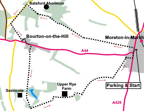
To view route as a dynamic Ordnance Survey map click here. Introduction: This walk is a pleasant countryside stroll. It starts in the centre of Moreton-in-Marsh and takes a circular route back via Batsford Park, Bourton-on-the-Hill and Sezincote. Archaeology suggests Moreton-in-Marsh was inhabited in the Bronze Age and certainly was an important point on the Fosse Way for the Romans. In was at one time owned by Westminster Abbey and the abbot developed it as a market town in the 13th Century. It enjoyed prosperity as an agricultural, then weaving centre. Many buildings date from the 17th and 18th Centuries. The town was an important staging post on the coach route from London to Worcester which also went through Broadway. This probably explains the considerable number of inns, relative to its size. Today it is a very busy town being on the junction of the A429 (The Fosse Way) and the A44 and traffic can be a nightmare. Having said that, I found it a pleasant town, less ‘twee’ than some of its neighbours. The walk route takes you past Batsford Park and the entrance to Batsford Aboretum and Garden Centre. I visited the arboretum (on a different day to the walk) and it is a very attractive place. On then to Bourton-on-the-Hill. As the name suggests, it sits at the top of a steep hill, with views over the valley. It has a number of attractive buildings, many dating from the 17th and 18th Centuries and a fine church, St. Lawrence’s, which is Grade I listed. The oldest parts of the church date from the 12th Century. There is a pleasant bench here, should you have a picnic. From
Bourton-on-the-Hill, the route passes Sezincote, where you will catch sight
of the house built in 1798 by Charles
Cockerell. He had served with the East India Company and built the house in
Moghul stile, complete with minaret and dome. It provided inspiration for
the Brighton Pavillion. It has some beautiful gardens which again, I visited
on a different day. Moreton-in-Marsh is easy to find on the
junction of the A429 and A44. Parking is something of a free for all in the
centre and I opted to find a quiet street but for the sake of consistency, I
describe the route from the Black Bear Inn which is pretty much in the
centre. Start: Directly opposite the Black Bear Inn, walk along Corders Lane, following the sign for “Batsford Aboretum 1½ miles”. At the end of Corders Lane, continue straight ahead along the footpath, again, signposted for Batsford Aboretum. Go through a kissing gate and follow the obvious footpath across the field. As you get to the far side, it then follows the left hand boundary. As you reach a sign which says “Confirmation Headland Please Keep Off “, turn left through a kissing gate then immediately right following a yellow arrow for the Moreton 8.
Reach a crossroads of paths (SP 186331) but keep straight ahead following the right hand field boundary. You arrive at the drive for Batsford Aboretum. Cross it and keep straight ahead following the Heart of England Way. At the end of the first field after the drive, go through a metal gate, into trees. Keep straight ahead climbing slightly. The track then divides. Take the right fork, climbing slightly on a broad dirt track. If you are at all uncertain, it is worth remembering that the route follows the boundary wall for the Batsford Park. Look out for a right turn off the broad track, on to a narrower footpath, following a Monarch’s Way yellow arrow (SP178334). Again, you are following the Batsford wall.
At the road, turn left to follow in for just under half a mile, passing a road junction. Turn left at a bridleway sign and follow it passing to the left of the trees (SP 169331). The bridleway drops down to a broad track. Turn left along it and follow it as it turns right in front of a stone barn, to the road. Turn left along the road. There is a pavement.
After about a hundred yards, turn right through the churchyard of St. Lawrence’s Church, to emerge in a lane at the rear. Turn right.
Turn right again at the next junction (opposite the phone box) and then after about fifty yards, turn left following the sign for “Heart of England Way”.
The path runs more or less in a straight line to Sezingcote, crossing its drive at a cattle grid. You will catch sight of the house with its ‘onion’ dome. Keep straight ahead. Note there is provision for the path to be either side of the fence, depending on when/if cattle are in the field.
After going through some trees, reach a tarmac lane (SP 175307). Turn left to follow it for just over half a mile. When it turns left, to Upper Rye Farm, keep straight on across the concreted area and follow the left hand boundary.
Beyond the barn, follow the right hand field boundary to the trees. Ignore the stile off to the right. At the trees, turn left to a gate then right, at the corner of the trees (SP 189312). Not far beyond the corner of the trees, look out for a post, perhaps about twenty/thirty yards to the left of the trees. The route passes this post which is marked with yellow arrows. The path curves left by a metal water trough to a gate. After the gate, the path is obvious along the right hand side of the trees. The path curves left at the end of the field. Follow the hedge on the left. Just before the next field, turn right keeping the hedge on the left. Almost at the end of this field, turn left indicated by a yellow arrow, again keeping the hedge on the left. Over to the right is the North Cotswold Hospital on the outskirts of Moreton-in-Marsh. Continue to follow the obvious path, passing the rear of some gardens. The path becomes a tarmac lane (Parkers Lane). Stay on this, past the fire station. Left at the main road will take you back to the centre of Moreton-in-Marsh. If you need to buy any hiking equipment/clothing before your trip see the Hiking Store All information on this site is given in good faith and no liability is accepted in respect of any damage, loss or injury which might result from acting on it.
| | |||||||||||||||||

.jpg)
.jpg)
.jpg)
%20View%20along%20Cotswolds%20Way%20just%20outside%20Moreton%20in%20MARSH.jpg)
%20Awaiting%20Collection.jpg)
%20View%20Near%20Batsford.jpg)
%20View%20near%20Blockley.jpg)
%20Looking%20down%20the%20main%20street%20at%20Bourton%20on%20the%20Hill.jpg)
%20Church%20of%20St%20Lawrence%20Bourton-on-the-Hill.jpg)
%20Inside%20St%20Lawrence%20church.jpg)
%20St%20Lawrence%20church.jpg)
%20Guilder%20Rose%20berries.jpg)
%20Lake%20at%20Sezincote.jpg)
%20Sezincote%20House.jpg)
%20Route%20back%20to%20Moreton%20in%20Marsh.jpg)