|
St. Anthony Head Walk (Roseland Peninsula)
|
Starting
point and OS Grid reference:

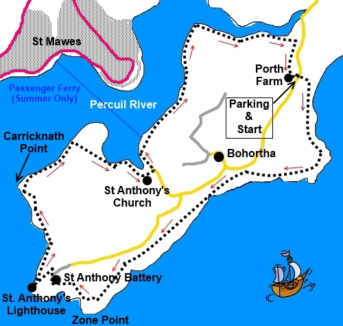
Porth
Farm car park (honesty box) (SW 868330)
|
Ordnance
Survey Map
OS
Explorer 105 – Falmouth and Mevagissey.
Buy this map from
List
of OS Maps
Note: If you use OS Maps on-line, you can download this route via this
link.
| |
Distance: 5.5 miles
| |
Traffic light rating:

(For explanation see My
Walks page)
| |


For advice on .gpx files see
My
Walks page
|

Click
the PDF logo above to give a printable version of this walk without the
photos.
|
To
view route as a dynamic Ordnance Survey map click here.
Introduction:
This walk to St Anthony Head on the
Roselamd Peninsula has to be one of the prettiest walks in Cornwall. It is
also very easy with virtually no gradients.
Similar to the St
Just to St Mawes walk, if you rely on a 1:25000 scale map to plan
your walks, in the absence of crisp eyesight or a magnifying glass, you
would be forgiven for thinking that the last stretch of this walk after St.
Anthony’s Church was not possible. However there are clear, well walked
paths and good signposting.
The walk includes three lovely beaches and
lots of interest.
At St. Anthony Head is The St. Anthony
Battery – the remains of a gun emplacement built in the late 19th
century and which was operational until 1956, protecting the port of
Falmouth from invaders in conjunction with fortifications at Pendennis
Castle and St Mawes. In 1956, the National Trust took over the property. It
is free to look round and there are toilets.
Also worth visiting on the site is the
Battery Observation Post built in the Second World War. This doubles as a
bird hide and there is a frieze identifying various visible landmarks.
On the top of the cliffs immediately above
the battery is an orientation table. There are some scenically positioned
benches which make good picnic spots.
Downhill from the battery is St Anthony
octagonal lighthouse built in 1835 to warn ships off the Manacles Reef.
The stretch of the walk along the Percuil
River overlooking St Mawes with many moored boats is especially attractive.
The walk starts at the National Trust car
park at Porth Farm. To get there, turn off the A3078 at Trewithian
signposted for Portscatho. Stay on this road, avoiding the turn offs for
Portscatho itself. Ignore the right fork for Percuil and not far after
joining the side of the creek, the car park is on the right.
Start:
From the car park (SW 868330), cross the road and into the farmyard.
There is a National Trust sign indicating Towan Beach. Bear left and
actually go through the archway through the barn.
Unless you actually want to go on to the
beach, divert to the right, away from the most worn track, after going
through the arch and join the coastal path at the cliff edge. Turn right.
Few instructions are really necessary as you simply follow the coast path.
%20Towan%20Beach.jpg)
You soon come to the “The Wreck Post”.
This was erected by the coastguard service to simulate a ship’s mast to
enable breeches buoy practice.
At a marker post by a bench, showing the
coastal path straight on and another footpath to the right, there is a
little track to the left which goes down to Porthbeor Beach, should you wish
to visit it.
%20Porthbeor%20beach.jpg)
You pass the end of some broad grassy tracks
on the right but ignore these and stay on the coastal path (1st
one at SW 850312).
%20St%20Anthony's%20Head.jpg)
At SW 848312 you reach the St Anthony B2 Gun
Pit.
%20St%20Anthony%20B2%20Gun%20pit.jpg)
%20View%20towards%20Falmouth.jpg)
After looking round the old military
installation, make your way along the tarmac track/road towards the car park
but take the path down to the left towards the lighthouse. The immaculately
kept lighthouse is worth a look but also down this path at the bottom, off
to the right, is the continuation of the coast path. Just before this is a
left turn to the Battery Observation Post.
%20St%20Anthony%20Lighthouse.jpg)
Return to and continue along the coast path,
passing the white painted old paraffin store for the lighthouse. The path
joins another, half way down a flight of steps (SW 847315). Turn left and
cross the footbridge by a lovely beach.
The circular configurations of St Mawes
Castle, built by Henry VIII, is clearly visible across the water.
%20St%20Mawes%20Castle.jpg)
Follow the headland round passed Carricknath
Point and as you get more or less opposite the little harbour of St Mawes
(SW 849324), the path forks off to the right cutting off a corner - if you
carry on as far as the trees (a nature reserve), there is a fingerpost to
the right for “St Anthony’s Church ½
mile” and “Place Quay ¾ mile”.
%20St%20Mawes.jpg)
At the top of the slope, through a kissing
gate, a yellow footpath arrow indicates your route which joins the drive to
Cellars Cottage. Turn right.
Fork right at a fingerpost for “Coast Path
Public Footpath Church and Place Quay ½ mile”.
At SW 854320, the coast path forks left. You
turn right at the church but please have a look round it first as it is
quite unusual for such a tiny place.
%20St%20Anthony%20Church.jpg)
%20Inside%20St%20Anthony%20Church.jpg)
When you reach the road, turn left and walk
down to the quay. This is used by the ferry to St Mawes at high tide. At the
head of the quay is a kissing gate on the right. Go through this and turn
sharp left to follow the fingerpost for “Porth Farm 1½ miles”.
%20Place%20Quay.jpg)
You soon pass a pontoon which the ferry uses
at low tide and enter (National Trust) Drawlers Plantation. There is also a
sign for “Porth Farm via Porthcuel River”.
%20Boats%20on%20Percuil%20River.jpg)
At SW 859330
ignore the first path to the right for Bohortha and another further on.
The footpath crosses the creek, not far
before Porth Farm (at which point it is little more than a muddy stream) via
a long footbridge (SW 868 29). Turn right after crossing and turn right on
the footpath parallel with the road back to the car park.
If you need to buy any
hiking equipment/clothing before your trip see the Hiking
Store
All information on this
site is given in good faith and no liability is accepted in respect of any
damage, loss or injury which might result from acting on it.
|


.jpg)
.jpg)
.jpg)