
|
|
|
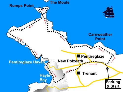
To view route as a dynamic Ordnance Survey map click here. Introduction: This walk to Pentire Head is very straightforward and easy to navigate. Pentire Head is a peninsular, around a mile square, jutting out into the Atlantic and where there is dramatic coast cliff scenery and an expansive view of Padstow Bay and the River Camel estuary It encompasses The Rumps, a triangular area which was occupied by an Iron Age fort to take advantage of its natural limited access. Ditch works are still visible. The walk takes you to Polzeath, a relatively modern holiday resort which has a fantastic beach renowned for surfing. The walk starts at a large National Trust car park for Lundy Bay. To get there, turn north off the B3314 close to St Minver, following signs for the Bee Centre. Pass this and continue for about another half mile. The car park is on the left. Start: From the car park SW 953795), cross the road and head down the footpath opposite to the coast. Here, follow the fingerpost for Pentire Point.
Until you get to New Polzeath, it is now simply a case of keeping the sea on the right! Pass a National Trust sign for Carnweather Point. At SW 934810, you arrive at a triangular promontory, The Rumps. There is path round this which I found worth taking to see the interesting rock formations. There is also a good view of The Mouls, a small island. There are also one or two spots for a picnic with good views. A fellow walker I met said he had seen some seals in the bay afterwards but I saw none.
At SW 930807 pass Rumps Point.
There is a trig point half hidden in a hedge at SW 929806 but this is in a field and not on the footpath or with public access. At SW 925806, to the right of the path is a plaque “For The Fallen”. It contains the immortal lines:
This famous poem was written here in 1914 by Laurence Binyon, as he overlooked the cliffs. You round the headland at SW 924805 and the vista opens up over Hayle Bay, Polzeath and the Camel Estuary.
The path comes down to the beach at Pentireglaze Haven (SW 936797). Continue to follow the waters edge past a number of apartment buildings, part of New Polzeath.
As you get to Polzeath itself, descend some concrete steps to a little lane by St Knightons. Turn left. After only few yards, arrive at a larger lane and turn left through the caravan site. As you walk through it, look out for a prominent public footpath sign on the left and fork off here. The footpath emerges into a field and you follow the right hand boundary along a clearly trodden path. Similarly, in a second field and as you approach its end, it curves right into the caravan site. Follow the caravan site’s lane to a cross roads and turn right. Follow the road for half a mile back to the car park. If you need to buy any hiking equipment/clothing before your trip see the Hiking Store All information on this site is given in good faith and no liability is accepted in respect of any damage, loss or injury which might result from acting on it.
| | |||||||||||||||

.jpg)
.jpg)
.jpg)
%20View%20towards%20Lundy%20Bay.jpg)
%20View%20at%20Downhedge%20Cove.jpg)
%20Approaching%20The%20Rumps.jpg)
%20The%20Mouls.jpg)
%20Looking%20back%20at%20The%20Rumps.jpg)
%20Polzeath%20Beach%20and%20Camel%20Estuary.jpg)
%20Looking%20back%20to%20Pentire%20Point.jpg)
%20Polzeath%20Beach.jpg)
%20Pentireglaze%20Haven.jpg)