|
Pentewan
to Black Head
|
Starting
point and OS Grid reference:

Pentewan
– Free car park (SX 018423)
|
Ordnance
Survey Map
OS
Explorer 105 – Falmouth and Mevagissey.
Buy this map from
List
of OS Maps
| |
Distance: 8.9
miles
| |
Traffic light rating:

(For explanation see My
Walks page)
| |


For advice on .gpx files see
My
Walks page
|

Click
the PDF logo above to give a printable version of this walk without the
photos.
|
To
view route as a dynamic Ordnance Survey map click here.
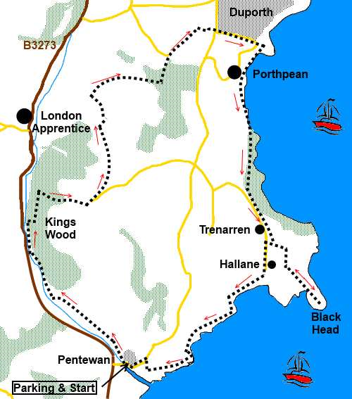
Introduction:
This walk from Pentewan, near St Austell starts off along the Pentewan
Valley Trail, alongside the St Austell River. The trail is the bed of the
former Pentewan Railway, constructed to bring clay and tin to Pentewan from
where it was shipped. The old
silted up harbour is still there which is interesting.
The trail passes through ancient woodland
which is home to a wide variety of trees, wild flowers, animals and rare
butterflies.
The climb out of the woods gives good views
over St Austell. Porthpean beach is a lovely stretch of sand. There are
public toilets here and a café may be open at peak times although it was
closed when I passed on a June Saturday (maybe due to inclement weather!)
and a picnic table as you leave the hamlet.
After an attractive cliff top walk, we end
back at Pentewan, an attractive village dating back to medieval times with
huge swathes of sand. There is a huge holiday park which does not detract
from the attractiveness as much as you might think. There are shops and The
Ship Inn which makes a pleasant end to the walk.
There is a free car park at Pentewan. To get
there, take the B3273 south off the A390 from St Austell. Turn left where
indicated after about 3 miles. The car park is just over the narrow bridge.
Please note that large sections of this walk
are under a tree canopy and so GPS readings are unreliable.
Start:
Turn left on leaving the car
park at Pentewan (SX 018423) and after crossing the narrow bridge, turn
right to follow the Pentewan Valley trail. After passing the cycle hire hut
and information board, ignore the little path off to the left and keep on
the main track.
On reaching a broad track with a two way
fingerpost marking directions of the Pentewan Valley Trail, turn right,
following the track by the river (SX 009480). There is a higher level narrow
path but it does not matter which you use.
%20Near%20start%20of%20the%20Pentewan%20trail.jpg)
Pass a caravan and camping site on the other
side of the river and a footbridge leading into it (do not cross it). There
is a very fancy fingerpost here – see photo.
%20Unusual%20Fingerpost.jpg)
Pass a stone bridge over the river and a car
park but stay on the Pentewan Valley Trail.
Pass an information board for Kings Wood. I
suspect by staying on the main track, you will end up at the bridge referred
to below at # but I opted to go via the woods
by taking the track going off to the right, immediately after the
information board (SX 007489). When
the track splits by a post with an oak leaf symbol, turn left.
There are a number of tracks leading off here
and there but ignore these, staying on the main track, which starts to
follow a small stream. Stay on the right hand bank.
You reach a broad track by a bridge (# referred to above) (SX 008493). Turn right.
You will come across various signs indicating
Kings Wood which can be quite confusing so do no take undue notice of these.
Having said that, at a three-way fingerpost by a road, turn right signed for
King's Wood.
You come to a rough car parking area. Take
the ridged concrete lane rising into the woods. This is an old sunken lane
to East and West Towan Farms but looks little used. Stay on this lane
ignoring turns off on the first bend.
As you get towards the top of the lane, the
view to the left opens out to give a vista over towards the “Cornish
Alps” – spoil heaps from the clay production industry.
%20View%20towards%20St%20Austell.jpg)
The lane joins a broad track going into a
field on the right but you turn left. Stay on the track between the farm
buildings and keep a look out for Towan Farm Cottage on the left, just
before a barn. Turn left here between the barn and the cottage
(SX 015492).
Go through the gate and turn right passing
behind the barn but start to bear left towards a pair of old gateposts next
to a power pole. From these gateposts, walk along to the right of the line
of trees which become an old field boundary wall which leads to a stile in
the corner.
Once over this somewhat precarious stile,
head towards the middle of the opposite left hand boundary of the next
field, next to another power pole. Here is a kissing gate and once through
this, head uphill for the diagonally opposite corner of the field.
Turn right through the gateway and pass in
front of Menagwins farmhouse and turn left to follow the farm drive (SX
016501). Stay on the drive as it “zigs” to the left and “zags” to
the right, then shortly after it bends again to the left, take the track to
the right for Roseweek Farm (SX 015505). Pass the farm then go left just
before a house named Cowslip.
The track bends left passing through
woodland. Remain on it until you pass gates either side, going into the golf
course. Turn right shortly after these gates following the public bridleway
fingerpost. There is also a sign for Park Matthews Cottage
(SX 023508).
Pass the cottage and take the footpath
straight ahead. When this divides in front of hospital buildings, take the
right fork (SX 027511). At the road, go straight ahead on the road to Lower
Porthpean. As the road bends sharp right, take the little footpath straight
ahead alongside the electricity sub-station.
At the junction with the coastal footpath at
SX 033509, turn right. Almost immediately, you pass a lookout post on the
left, which is worth climbing for the view of the beach.
%20Porthpean%20Beach.jpg)
Continue following the coast footpath along
the “prom” behind the beach and up the road. At the bend, turn left
following the fingerpost for “Coast Path and Public Footpath Trenarren 1¼
miles”. There is a picnic table and bench here.
The footpath comes out on the road above
Trenarren. Go briefly left then, when the road bends right at a no through
road sign, go left indicated by a footpath marker.
A few yards further on, a post indicates the
coast path goes off to the left but stay on the track straight ahead. When
the track forks, take the right fork for “Coast Link”.
At a crossroads of tracks with several blue
arrows, keep straight ahead for Black Head, the site of an ancient
promontory fort. Unfortunately, the weather was inclement at the time of my
visit so I was unable to enjoy the views from here which I understand are
very good.
From Black Head, retrace your steps to this
crossroads and turn left (this is an easier track than the one which
indicates the bridleway runs out)
When you get to the road which is the access
road to the coastal properties, turn left and at the bottom turn right on to
a public bridleway “Coast Path (Hallane) ¼ mile”. When the bridleway
divides with coast path arrows in both directions, fork right.
Cross a stile next to a gate for Hallane
Mill. At the mill, (SX 033483) turn right.
%20Statues%20at%20Hallane%20Mill.jpg)
As the path climbs, turn left over a bridge
(SX 033482). Later cross another footbridge at SX 030480 (Vans West).
%20View%20SW%20on%20coast%20path.jpg)
%20Looking%20back%20towards%20Black%20head.jpg)
As you get closer to Pentewean, the path runs
next to the dangerous and steep Polrudden Cliffs so take care!
The path joins another just above Pentewan
village. Turn right. Pass in front of some attractive white painted cottages
with verandas and at the road, turn left into the village.
%20Pentewan%20Village%20Centre.jpg)
%20Harbour%20Pool%20at%20Pentewan.jpg)
If you need to buy any
hiking equipment/clothing before your trip see the Hiking
Store
All information on this
site is given in good faith and no liability is accepted in respect of any
damage, loss or injury which might result from acting on it.
|


.jpg)
.jpg)
.jpg)