|
Mevagissey
to Dodman Point
|
Starting
point and OS Grid reference:

Mevagissey
- Willow Park car park (SX 013451)
|
Ordnance
Survey Map
OS
Explorer 105 – Falmouth and Mevagissey.
Buy this map from
List
of OS Maps
Note: If you use OS Maps on-line, you can download this route via this
link.
| |
Distance: 9.9
miles
| |
Traffic light rating:

(For explanation see My
Walks page)
| |


For advice on .gpx files see
My
Walks page
|

Click
the PDF logo above to give a printable version of this walk without the
photos.
|
To
view route as a dynamic Ordnance Survey map click here.
Introduction:
This walk from Mevagissey is a lovely
mixture of dramatic coastal scenery, picturesque fishing villages and wooded
countryside. It is an easy walk with no significant gradients. There are
options to shorten the walk if weather or enthusiasm falter, notably from
Gorran Haven, where a short walk of a mile inland, along the lanes, will
take you to Gorran Churchtown, to pick up the route described.
There are various refreshment opportunities
at cafes/pubs at the villages visited and along the coast path are dotted
various benches for picnics.
Mevagissey is an attractive fishing village
where fishermen still ply their trade and you can buy freshly caught fish.
The walk starts from the main Willow Park pay
car park which is reached by entering the village via the B3273. The car
park is on the left. Entering the village any other way will embroil you in
the one way system and narrow, steep streets and frankly is not worth the
effort. The village is all yellow lines and all the other car parks are
limited stay, which will not allow you enough time for the walk.
As this is a circular walk, you could also
park at Gorran Haven (pay car park) or there is a tiny National Trust car
park at Penare (SX 999405) with a modest charge at an honesty box.
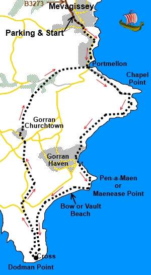
Start:
Turn left out of the car park and in the centre, turn right. Have a look at
the harbour then continue along the road for ¾ mile to Portmellon.
%20Narrow%20street%20in%20Mevagissey.jpg)
%20Mevagissey%20inner%20harbour.jpg)
%20Portmellon.jpg)
Continue along the road at Portmellon (SX
016440) climbing out of the village and soon turn left along Chapel Point
Lane. A finger post indicates the coastal footpath. As the houses end, the
road becomes a private drive to Bodrugan and Chapel Point, though walkers
are allowed.
At SX 020435 is a post indicating that the
coastal path goes off to the left. However, this is a steep descent with
little to gain and I preferred the better views back to Mevagissey and over
Chapel Point by remaining on the drive. It is up to you. Both routes finish
up at the entrance gates to Chapel Point (SX 026433).
Looking%20back%20towards%20Mevagissey.jpg)
%20Chapel%20Point.jpg)
Assuming you have remained on the drive, you
descend to Chapel Point, a rather select group of residences in an idyllic
location. Just before reaching the gates (SX
026433), turn right to follow the coastal footpath.
You enter the National Trust land
Bodrugan’s Leap.
%20Foxgloves%20on%20the%20coastal%20path.jpg)
%20Approaching%20Gorran%20Haven.jpg)
Continue to follow the footpath to Gorran
Haven. It emerges into the village by the drive to Terhaver House. Turn
right and follow this lane to its end and turn left to descend into the
village, passing a pleasant little church, with its “boat hull” roof,
which is worth a look.
%20Gorran%20Haven%20Church.jpg)
%20Goran%20Haven%20Church%20interior.jpg)
%20Gorran%20Haven.jpg)
Follow the road around the sandy cove, then
turn left along Foxhole Lane (SX
014415) and Up some steps. The public footpath fingerpost indicates
“Hemmick via Dodman 3½ miles”.
You enter the Lamledera National Trust land.
Soon the fabulous Bow or Vault Beach comes into view.
%20Bow%20or%20Vault%20Beach.jpg)
At SX 016410 there is a split in the path.
The left hand path goes to the beach. Keep right to continue the walk.
You enter the Dodman National Trust land.
You arrive at a three way fingerpost (SX
003399), at the end of an ancient earthwork which crosses the Dodman Point
peninsular. To the right is “Penare 1/3 mile” and
left “Dodman Point ¾ mile”. Taking the route to Penare shortens the
walk but misses out the views from Dodman Point.
Follow the coast path to Dodman Point (SX
002493) where there is a large cross, originally built in 1896 as a
navigational aid, and great views across Veryan Bay.
%20Memorial%20Cross%20at%20Dodman%20Point.jpg)
%20View%20over%20Veryan%20Bay.jpg)
With your back to the cross (and the sea
behind you!), walk straight ahead along the short stretch back to the
coastal path and cross it, taking the path ahead. You soon pass the trig
point and The Watch House (one of the National Trust’s smaller
properties!). This dates from the 18th century and is a survivor
of a chain of signal stations built during the Napoleonic Wars.
%20The%20Watch%20House.jpg)
Go through a kissing gate with a large
granite gatepost alongside on the left and continue straight ahead to the
left of the fence. When the fence stops, keep straight ahead following the
higher level of the open land. As a hedge on the left turns left (SX
003459), cross the stile in the left hand corner. The footpath is now
flanked on either side by old walls.
You reach a broad track with an information
board on the corner. Turn right here – which is along the course of the
ancient earthworks.
You soon turn left at a fingerpost for
“Penare 1/3 mile”.
On reaching the road (SX 000404), turn right
and walk along the road for a quarter of a mile, ignoring the paths that go
off at a corner by Holiday Cottage Bodrugan (National Trust).
At the next road junction (SX 000407), take
the footpath straight ahead indicated by the fingerpost for “Treveague 1/3
mile”. [In September 2020, it was reported to me that this fingerpost
is missing. If you happen to find it restored, it would be appreciated if
you could let me know. The route is straight across the road from the
junction to Treveague Farm]. Walk straight across the campsite on the track passing the farm and
at the drive to the farm, turn left to follow it.
At the road junction, turn right. Walk along
the road to the first farm you come to (Carvinick) (SX 000406) and look out
for the footpath immediately after the farm on the right, hidden in the
hedge and up some steps. Turn left at the top of the steps then right
indicated by a marker post.
After passing the barn, the path bears
slightly left to an obvious walkers’ gate about halfway along the opposite
side of the field. Continue to follow the same direction for Gorran
Churchtown. The path exits into the road and the church is straight ahead.
Rather than walk on the road, there is an elevated footpath alongside.
Turn right just before the church on to a
“no through road” and follow this as it bends round left behind the
church. Ignore the small junction on the right. Follow the fingerpost for
“Galowras Mill 1 mile”.
Turn off this track to the right, on to the
drive to Cotna Barton (the finger post indicating this is actually to the
left of the track) and almost immediately, bear off left as indicated by a
marker post.
Cross a stile at the end of the field and
follow the fingerpost then over another stile made of vertical stone slabs,
after which the path bears right at about 45°. Cross another similar stile
with some steps, then descend into a wooded valley along a steep grassy
path.
%20Wooded%20valley.jpg)
You enter West Bodrugan Woods Nature Reserve.
Shortly after passing a stagnant pool, there
appears to be a path off to the left but ignore this.
When you arrive at a broad track (SX 006436),
turn right briefly, then left through a gate continuing the West Bodrugan
Woods Nature Reserve. There is a public footpath fingerpost.
The path exits the woods into more open land
over a wooden stile and bears slightly left. After crossing some wooden
steps into a grassy pasture, follow the left hand boundary to Portmellon,
turning left at the first tarmac you come to. At the cove, turn left to
retrace your steps to Mevagissey.
If you need to buy any
hiking equipment/clothing before your trip see the Hiking
Store
All information on this
site is given in good faith and no liability is accepted in respect of any
damage, loss or injury which might result from acting on it.
|


.jpg)
.jpg)
.jpg)