|
Coverack
to Porthoustock
|
Starting
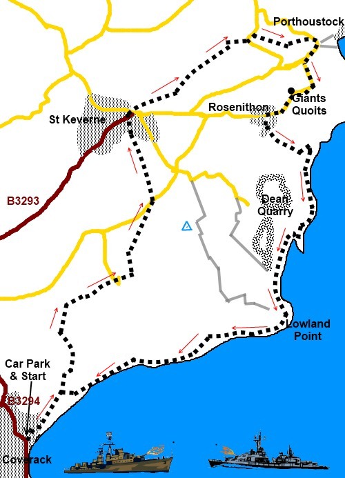
point and OS Grid reference:

Car
park on B3294 at entrance to Coverack (SW 782186)
|
Ordnance
Survey Map
OS
Explorer 103 – The Lizard - Falmouth and Helston.
Buy this map from
List
of OS Maps
Note: If you use OS Maps on-line, you can download this route via this
link.
| |
Distance: 6.6 miles
| |
Traffic light rating:

(For explanation see My
Walks page)
| |


For advice on .gpx files see
My
Walks page
|

Click
the PDF logo above to give a printable version of this walk without the
photos.
|
To
view route as a dynamic Ordnance Survey map click here.
Introduction:
This walk from Coverack follows the pretty, ancient way between Coverack
and St Keverne with its attractive market square and church. The return via
the Coast Path has industrial archaeological
interest, including the old Dean Quarry and remains of the 2nd
century Trevarbeth Salt Works.
Coverack itself is probably the most
attractive coastal village on the Lizard Peninsula with a typical stone
built harbour and good beach. The beach is interesting geologically in that
the boundary between the Earth’s crust and mantle are visible on the
beach. An information board next to the car park explains.
I did this walk in early summer when the wild
flowers were prolific.
The walk is very easy with little gradient.
This is a circular route so could equally be
treated as a walk from St Keverne if that happens to be more convenient.
The walk starts from the parking spaces on
the northern approach to Coverack village on the B3294, where there is an
“honesty box” for local charities. There is also a pay and display car
park and toilets next to it. Other parking in the village is very limited.
To get to Coverack, follow the B3293 off the A3083 from Helston to Lizard,
then turn off on to the B3294.
Refreshments are available in Coverack and St
Keverne. There are picnic tables by the pebble beach at Porthoustock and
public toilets.
%20Coverack%20Harbour.jpg)
Start:
Turn right out of the car park (SW 782186) and immediately left on the Coast
Path, where the road bends right to Coverack. There is a fingerpost for
“Public Byway Porthoustock 3½ miles”.
%20Coverack%20from%20across%20the%20bay.jpg)
Follow the tarmac lane and as the tarmac runs
out by Tregatreth Cottage, look out for a three way fingerpost on the left
for “Public Footpath St Keverne via Trevalsoe 1½ miles” and take this
path (SW 785190). The cottage owners have very kindly provided a bench at
this point.
Shortly after a kissing gate, the track
appears to fork – keep left, passing alongside a short stretch of
dilapidated wall before coming to another kissing gate.
At a confusing junction of field gates, go
right as indicated by the white arrow.
Go straight across the next field and after
passing some cattle pens, join the farm lane through a gateway and turn
right. Follow the lane to the farm and go straight through the farmyard,
bearing right and a post with a yellow public footpath arrow confirms the
route.
On reaching a tarmac road, turn right and at
the drive to Trevalsoe Farm (SW 791200), turn left and walk initially down
the right hand boundary of the field, Ignore the right turn over the wall
indicated by a yellow footpath arrow. As the field opens out, the path goes
straight across the middle, then, after crossing a stone stile, turns right.
After a series of stiles and fields, come out
at the entrance to Trebarveth Farm (SW 793205). Turn left here across the
road and over the stone stile following the public footpath fingerpost to St
Keverne.
You come out into a lane by some allotments
(behind you to the right). Go straight ahead and you come out in St Keverne
opposite the White Hart pub. Walk diagonally across the square and into the
churchyard – there is a public footpath sign. The path runs down the left
hand side of the church. At the crossroads of paths in the churchyard, keep
straight ahead and follow the right hand boundary wall.
%20St%20Keverne.jpg)
You leave the churchyard via a metal kissing
gate and through a wooden one immediately after. Follow the obvious track,
along the left hand boundary of the first field and the right hand boundary
of the second. Cross a concreted farm track and follow the clearly marked
footpath ahead.
%20Fungus.jpg)
Go through the woods and cross a stone stile
where the path divides and the path to the left goes uphill. Go right. At
the road (SW 800219), turn left indicated by a footpath marker then, after a
hundred yards or so just past a cottage, turn right (SW
801219).
The path joins a broad track by some pretty
thatched cottages at Porthoustock. Follow this down to the cove.
%20Thatched%20cottages%20at%20Porthoustock.jpg)
Porthoustock Cove is not the most attractive
of places having been a working harbour serving the nearby quarries. It is
dominated by ugly concrete constructions. There is a pebble beach and some
picnic tables on the green.
From the cove, with your back to the sea,
turn left along the road passing a fingerpost confirming the Coast Path.
After three bends, turn left at the junction (SW 805217) passing the
entrance to the quarry. Strictly, the Coast Path goes off to the right here
across the fields, cutting off a corner but if you go this way, you will
miss the Giants Quoits by the side of the road (SW 805215).
%20Giants%20Quoits.jpg)
The Giants Quoits were originally at Manacle
Point and were re-sited because of the expanding quarry workings.
Stay on the road to the pretty hamlet of
Rosenithon and in its centre turn left by the post box (SW 802212). Follow
the lane until your way is blocked by the gate to a private house and turn
left. There is a footpath sign.
Follow this track down to the coast at
Godrevy Cove, where the path turns left (SW 805209) and briefly seems to go
in the wrong direction, contrary to the map, but it arcs round to follow the
top of the beach to a marker post at the end of the beach. Climb the path
and follow it along the coast, turning left at the quarry gate.
%20Beach%20at%20Godrevy%20Cove.jpg)
It is now a case of following the coast back
to Coverack. Its route round the quarry is clearly marked.
%20Old%20quarry%20jetty%20near%20Dean%20Point.jpg)
There is an information board at SW 803199
which tells you about Dean Quarry, the Trevarbeth Salt Works and Lowland
Point.
%20Coast%20Path%20in%20bloom.jpg)
The footpath comes out on a broad stony
track. Turn left and follow the track back to the car park.
If you need to buy any
hiking equipment/clothing before your trip see the Hiking
Store
All information on this
site is given in good faith and no liability is accepted in respect of any
damage, loss or injury which might result from acting on it.
|


.jpg)
.jpg)
.jpg)