
|
|
|
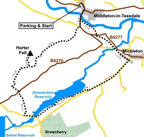
To view route as a dynamic Ordnance Survey map click here. Introduction: This is a super walk with views across the water of
Grassholme Reservoir and long distance views from the top of Harter fell.
Navigation is straightforward as much of the route follows the Pennine Way.
The only potentially tricky part is an ‘off piste’ climbing of Access
Land to visit the summit of Harter Fell, which is quite steep, hence the
amber traffic light. If preferred the walk can be enjoyed without this
diversion. Middleton-in-Teesdale
is a small market town and the main one in the Upper Teesdale Area. It came
into its own from the early 19th Century when the London Lead
Company moved its main headquarters there. It was responsible for many of
the buildings. In September 1877, an elaborate fountain was unveiled to
honour Robert Walton Bainbridge, superintendent of the London Lead Mining
Company. Middleton-in-Teesdale
was also the terminus of the railway, opened in 1868, from Barnard Castle,
until the Beeching axe fell in 1964. Its disused route now forms part of an
early section of this walk. There
are a number of independent shops in Middleton and the town has a pleasant
feel to it. Classed
as the Lunedale Reservoirs, Grassholme and the nearby Selset were built to
provide water for the lower Tees valley. Grassholme was constructed just
before the First World War. It necessitated the demolition of a mill, six
dwellings and a farmstead. There was also a humpback bridge which I believe
reappears when the water is very low. Selset
was built in the 1950s. The
area is one of a number of Dark Sky Discovery Sites, around the UK and there
is an observatory at Grassholme Reservoir where events are held
periodically, for people to enjoy the stars. Harter
Fell rises to 1578ft (481m). From its trig. point there are good views as
the hill’s flanks fall away quite steeply on most aspects. On its eastern
side are the remnants of old quarry workings and the ruined buildings, one
of which is the old engine house, are visible from the route I describe. The
quarry produced Whin Stone, a hard, dark coloured rock. Its hardness made it
ideal for building cobbled roads. The rock is no doubt part of the Great
Whin Sill, which provides the ‘edge’ over which flows the High
Force waterfall. My
walk starts from Middleton-in-Teesdale. This sits on the B6277, about 9.5
miles north-east of Barnard Castle. There is free on street parking although
this can get quite congested. However just round the sharp bend on the
B6277, as you leave the town, there is a free car park where I got parked
with no problems. Start: From
the centre of Middleton-in-Teesdale, by the Bainbridge fountain walk down
Bridge Street and cross the bridge. Opposite the cattle market, take the
broad track to Step Ends Farm, following a public footpath fingerpost. Follow
the track alongside the river and after going through a gateway, bear right
towards the trees. Cross two step stiles and follow the path to the main
road (B6277). Take care because the road can be busy but turn left along it
for only a few yards, crossing to go through a slit stile on the right,
indicated with a public footpath fingerpost. Follow this footpath to a
concrete step stile and cross this to join the route of the disused railway
(NY 954244). Turn left along it. Cross the viaduct and the road bridge over the railway route, climb some steps to join the road. Turn left up the road for 1.2 miles. Although road walking can be a little tedious, there are some great views to be enjoyed across the valley.
At the clearly marked entrance to Grassholme Reservoir (NY 949245), turn right down to it. Normally, you can walk either way round the reservoir but due to extensive maintenance work, only the south eastern bank was available to me, past the visitor centre and to the right of the boat enclosure.
Whichever you use, follow the bank side footpath to the road bridge at the far end and here, turn right along the road. There are some picnic tables here which might be ideal for a stop but they were out of bounds at the time of my visit.
Follow
the road to a farm on the right (Grassholme) and turn right through the
farmyard, following the fingerpost for “Pennine Way” and “Wythes
Hill” (NY 926216). The
Pennine Way route rises fairly obviously from the farm. eventually passing
to the left of a stone barn then to the right of a second, after which it
follows the left hand boundary of the field. Follow the obvious route more
across the middle of the next fields to arrive at the road (B6276).
Cross
the road and continue up the drive to Wythes Hill, passing to the left of a
semi-circular barn, still following the Pennine Way. Follow the track through the farm, passing the ‘Tuck Shop’.
After
Wythes Hill farm, continue to North Wythes Hill (signed). Follow the obvious
track and the Pennine Way markers. From
the farm, the path continues with walls either side, then you enter a field,
climbing steadily. The Pennine Way leaves this field from just short of the
far right hand corner. Ignore the other path going straight ahead. Continue to meet a broad stony track at NY 924232 and turn left briefly. Go through a gateway and turn right. There is a waymarker by the largely redundant stile.
The
track then curves right through another gate marked with a yellow waymarker. Continue
to follow the obvious track until, after going through a gateway, you will
realise that the land to the left is unenclosed by walls (NY927233). This is
the start of a stretch of Access Land where there is your opportunity to
visit the trig. point on the summit of Harter Fell (NY 928238). There is no right or wrong way up this steep stretch but on the basis of my approach, I recommend climbing more or less parallel with the wall on the left to start with. You might spot a faint path. After three or four hundred yards, break right for the summit. You may not see the trig point until you are close to it as there are ‘false summits’.
It
is probably possible to continue along the ridge and rejoin the main track
but I opted to return to it at the point I left it and continue along the
Pennine Way from there. From the track at about NY 930235, over to the right you will note some ruins connected to an old quarry.
Pass
to the left of a large cairn, across the moorland, avoiding the path off to
the right. At NY 935241 there is a path off to the right but ignore this and continue following the Pennine Way.
The
path drops down to meet a road opposite a creeper/ivy covered cottage. Turn
right and at the junction with the main road (B6277), turn left to get back
to Middleton-in-Teesdale. It is about half a mile back to the centre and
there is a pavement. If you need to buy any hiking equipment/clothing before your trip see the Hiking Store All information on this site is given in good faith and no liability is accepted in respect of any damage, loss or injury which might result from acting on it.
| | |||||||||||||||||

.jpg)
.jpg)
.jpg)
%20Harter%20Fell.jpg)
%20View%20over%20Teesdale.jpg)
%20Looking%20over%20Grassholme%20Reservoir.jpg)
%20Walking%20by%20Grassholme%20Reservoir.jpg)
%20Roadbridge%20at%20the%20end%20of%20Grassholme%20Reservoir.jpg)
%20View%20along%20Grassholme%20Reservoir.jpg)
%20Barn%20passed%20on%20the%20climb.jpg)
%20View%20SE%20to%20Brownberry%20Plantation.jpg)
%20Wythes%20Hill%20tuck%20shop.jpg)
%20View%20over%20Wythes%20Hill%20to%20Selset%20Reservoir.jpg)
%20View%20from%20Harter%20Fell%20trig%20point.jpg)
%20Looking%20down%20on%20Grasholme%20Reservoir.jpg)
%20Ruins%20seen%20on%20descent%20to%20Middleton%20in%20Teesdale.jpg)
%20Looking%20down%20on%20Middleton%20in%20Teesdale.jpg)
%20Looking%20back%20to%20Harter%20Fell.jpg)