
|
|
|
To view route as a dynamic Ordnance Survey map click here. Introduction: This is an easy walk, or would be but for a couple of obstructions (see Note at the end). It takes you over pleasant countryside with nice views to the upmarket looking place Romaldkirk with its spectacular church, huge village green, water pump and a great pub (check opening times). This walk could be combined with my Mickleton to Middleton in Teesdale walk either as a ‘figure of eight’ walk or as a long loop by starting either at Romaldkirk or Middleton, walk if you wanted a longer walk. Mickleton is a small pleasant
village with one unusual aspect in that it (amongst other land) is the
subject of a 1000 year lease between the Bowes family and four local yeomen
farmers. This enabled the Bowes family to raise capital of some £1570, in
1607, which the Bank of England calculator says would be the equivalent of £473,182
in 2020. What happens when the lease expires is anybody’s guess but as
this is not until 2607, not many of us need to worry about it! The Blacksmith’s Arms in Mickleton is a real find with pizzas to die for but check opening times! Romaldkirk is an attractive well spread village by reason of its huge village green. It may be named after a St. Romald (or St Rumwald). The church certainly is (‘Kirk’ being from an Old Norse and Scots word meaning ‘church). It is late 12/early 13 century and Grade 1 listed. It has a prestigious pub, the Rose and Crown.
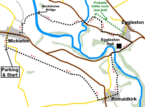
Clearly many birds nest in its ivy! The walk starts from a free car park on the Tees Railway walk at Mickleton. To get there, take the B6277 from Barnard Castle. Pass through Cotherstone and Romaldkirk. Mickleton is next. Turn left opposite the Blacksmith’s Arms, following the tourist sign for Tees Railway Walk, Mickleton Station 300 yards. As the lane bends left, the entrance is straight ahead and clearly marked. There is parking for several cars and picnic tables. Start: From the car park, walk back down the lane to the main street opposite the Blacksmith’s Arms and turn right. After about three hundred yards, turn left down Robinson’s Bank. At the junction, turn right and almost immediately left, following a fingerpost for “Beckstones Bridge”. Just before the national speed limit sign, turn right down a walled track into a field (NY 973240). Once through its gate, bear left, crossing a ditch in the centre of the field to a gate you can see. The walked grass of the path was visible and in any case, you can see the bridge ahead of you.
Cross the bridge and turn right following the public bridleway sign.
At the end of the field, go through a gate and continue straight ahead, following the right hand boundary. In the next field, bear left to a walker’s gate about half way along the field. Beyond this, you enter a walled/fenced footpath, which you follow until you get to a road. Turn right along the road for a few yards, crossing Eggleston Burn, then turn left following a public footpath fingerpost (NY 989240).
Climb the short, steep banking and turn left to follow the burn for two fields. At the end of this second field, cross a stile with a gate and bear right indicated by a yellow arrow to a gate ahead. Go through that gate and immediately right to a second gate from which, follow the right hand boundary. At the far side of the field, keep straight ahead, after crossing the farm drive (see note # below), in the direction of the yellow arrow, roughly following the right hand boundary of the field to a stile at the bottom. Cross and turn right. At the bottom of the field was a very precarious, dilapidated stile. If it is still in the same condition when you do the walk, I recommend ignoring it and following the right hand field boundary. At the end of the field turn right (NY 993238). Follow the field down to the road. Here was the worst obstruction. There should be a gate/stile access to the road but it looked to be (at least) two gates fastened together and immoveable. The dilapidated post for a direction finger was visible in the verge (see note # below). A climb over the gate and scramble through the hedge gained access to the road. Turn left to Eggleston. Take care because the exit is at a blind bend and traffic is quite fast. At the road junction, which has a triangular grassy island, turn right in the direction of the road signs for the B6281 to Cotherstone and Romaldkirk. Follow the road down, passing the entrance to Eggleston Hall and cross the river.
Around a hundred yards after crossing the bridge, turn left over a stone stile following the fingerpost for “Teesdale Way and Romaldkirk ¾ mile”. Follow the obvious path above the river and when you get to a block wall follow it to its end then follow the left hand field boundary to a stone step stile. Over this, follow the right hand boundary briefly then bear left. The path is well walked and obvious. The village of Romaldkirk is ahead.
The path leads to a stone step stile. Cross and follow the fingerpost for the “Teesdale Way”.
At the road, turn right for the village centre and the B6277. Cross this road and continue straight ahead for about two hundred and fifty yards. At a sign for the “Tees Railway Walk”, turn right along the old railway track. After one and three-quarter miles, arrive back at the car park.
# Note: There are a couple of places on this walk where progress is hampered by a dangerously dilapidated stile (easily avoided) and a blocked egress on to the road at Eggleston. The path to the road is on the OS map and on the Co. Durham definitive map. Both issues have been reported to County Durham Public Rights of Way Officer who in particular confirmed that the egress route to the B6282 is extant. Investigations to be made as priorities allow! With hindsight, at the point of crossing the farm drive referred to above, it would have been better to turn left along this drive for about a hundred yards to join another footpath at NY 991242. A right turn would have resulted in more or less a straight line to Eggleston. However, I can only describe what I actually walked. I cannot vouch for the ease of passage on this alternative route. If you need to buy any hiking equipment/clothing before your trip see the Hiking Store All information on this site is given in good faith and no liability is accepted in respect of any damage, loss or injury which might result from acting on it.
| | |||||||||||||||||

.jpg)
.jpg)
.jpg)
%20Approach%20to%20Beckstones%20bridge.jpg)
%20Beckstones%20Bridge.jpg)
%20River%20Tees%20at%20Beckstones%20Bridge.jpg)
%20Walled%20fenced%20footpath.jpg)
%20View%20en%20route%20to%20Eggleston.jpg)
%20Another%20view%20en%20route%20to%20Eggleston.jpg)
%20Waterfall%20near%20Eggleston%20Bridge.jpg)
%20Eggleston%20Bridge%20and%20Eggleston%20Hall.jpg)
%20View%20after%20leaving%20Eggleston.jpg)
%20Romaldkirk%20Village%20Green%20and%20pump.jpg)
%20St%20Romald's%20Church.jpg)
%20Inside%20St%20Romald's%20Church.jpg)
%20View%20from%20the%20old%20raiolway%20track.jpg)
%20Bench%20with%20a%20view%20on%20the%20old%20railway%20track.jpg)