|
Gaunless
Valley and Woodland
|
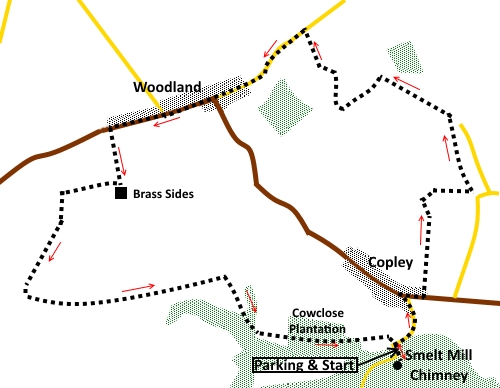
Starting
point and OS Grid reference:

Car
park just outside the village of Copley (NZ 087250)
|
Ordnance
Survey Map
OL31
North Pennines – Teesdale & Weardale.
Buy this map from
List
of OS Maps
Note: If you use OS Maps on-line, you can download this route via this
link.
| |
Distance: 5.3 miles
|
Date of Walk: 7 October 2014
| |
Traffic light rating:

(For explanation see My
Walks page)
| |


For advice on .gpx files see
My
Walks page
|

Click
the PDF logo above to give a printable version of this walk without the
photos.
|
To
view route as a dynamic Ordnance Survey map click here.
Introduction:
This walk starting
at the upper end of the Gaunless valley is a pleasant easy country
ramble. The walk starts at Copley with an opportunity to see a massive lead
smelt mill chimney and passes through the former mining village of Woodland,
with its unusual St Mary’s Church, made of corrugated iron.
The area was dotted with
lead and coal mines, now closed and there is evidence here and there, not
least the massive chimney at Copley, now a listed building. It was built in
1832 and carried away the noxious fumes from lead smelting from the Gaunless
lead mill.
At one time there would
have been a long flue connected to the chimney but little of this now
remains.
Across the road from the
car park where you start the walk, is a cluster of former mine buildings.
They are now residences but you can pick out the former store sheds and
furnace house and the imposing mine manager’s house. An information board
in the car park explains more.
Woodland is a long, narrow
village, strung out along the B6282. It is over 1000 ft above sea level and
has fine views, particularly to the south and on a clear day to the Cumbrian
Mountains, the North York Moors and (it is claimed) the east coast and North
Sea.
En route, you will see
signs for the Gaunless valley Trail and Steele Road. In fact, I discovered I
had more or less done the Gaunless Valley Trail but in reverse.
The walk starts from a car
park just to the south of Copley, on the road from Barnard Castle. It is off
to the right on a sharp right hand bend, just before crossing a bridge with
a stone cottage next to it.
Start:
From the car park (NZ 087250), walk up the hill on the path behind the information
board. The huge chimney appears amongst the trees and though large as it is,
it can take some spotting amongst the trees.
%20Smelt%20mill%20chimney.jpg)
%20Former%20mine%20managers%20house.jpg)
Retrace your steps to the
car park and turn right along the road into Copley. At the road junction,
turn right on the B6282.
After no more than 100
yards, at the end of a row of terraced houses, turn left on a concrete
footpath path (NZ 088253). This is unmarked and easy to miss. If you get as
far as the children’s playground, you have missed it!
Cross a stile into a field
and the next stile is visible.
Walk up the middle of the
next two fields and follow the left hand boundary of the third.
On arriving at the stony
track leading to a farm, turn right, then almost immediately left on another
stony track (NZ 088258).
When the track splits, the
left hand arm going to another farm, keep straight ahead.
Follow the track as it
curves right, passing in front of a barn. Pass through a gate and into the
next field. The path is not clear but you need to bear left and head for the
diagonally opposite corner, across the rough pasture. The route involves
something of an obstacle course of patches of shrubbery. You may notice the
churchyard to the right.
In the corner is a
ramshackle stile into the woods (NZ 089263). Again, the path is unclear and
there may be an element of forcing through weeds etc. Head towards the left
of West Softley Cottage and turn left up the broad track (NZ 089264).
%20Views%20to%20the%20south.jpg)
%20Views%20to%20NY%20Moors.jpg)
After just over a quarter
of a mile, continue to follow the track, as it turns left through a gate (NZ
085266) and stay on it to Lunton Hill Farm. Just before the farmyard, turn
right, through a gate, on a broad track. Stay on this and at the road (NZ
081269), turn left. There are good views along here, mainly to the south and
east. There are occasional glances of open moor land to the north.
Pass through the village of
Woodland with its unusual corrugated iron church. Sadly, the pub was closed
and up for sale as I passed but a bench on the village green, with good
views, provided a lunch stop.
%20St%20Marys%20church.jpg)
Pass the children’s play
area on the left and just as the road starts to dip, look out for an old
fashioned vertical green footpath marker on the left (NZ 069264). Cross the
stile here and follow the right hand boundary of the field towards the farm
(Brass Sides).
Just before the farm, turn
right over a stone stile (NZ 070260) and follow the footpath alongside two
derelict farm buildings. After about three stiles, at the next farm, the
path is directed clockwise around it, going through three walkers’ gates.
After the third gate, turn left, following the left hand side of the field
(NZ 066260).
About two thirds of the way
down, head right, for the bottom right hand corner of the field where there
are two stiles. Over these, head very slightly right. You cannot see the
next stile (gated stile) until you are almost up to it.
Cross this and the next
stile is visible. After this, follow the left hand field boundary.
Pass along a short, fenced,
section of path and at the end of it turn left (NZ 064253). When you come to
a double row of fencing with trees planted between the two, keep to the left
hand side of the double row.
Pass through the gate about
half way along the far side of the field and into rougher pasture, passing
some old mine spoil heaps and a small lake.
You join a broader, clearer
track.
After crossing a little
wooden bridge, keep straight ahead up the short hill. Once you get to the
top, the way ahead is obvious.
After a couple of steep
ladder stiles, turn right indicated by a blue bridleway arrow (NZ 076255).
Over the brow of the hill
in the next field, you will see the way ahead. Follow the well worn path
into the trees and as it curves left to a walkers’ gate. Through this,
turn right.
After the next gate, follow
the track along the higher part of the field. Do not drop down to the lower
level near trees. The track leads you into the woods and you follow it along
the edge of the trees. When it splits, take the right fork. Follow to the
road and turn right back to the car park.
If you need to buy any
hiking equipment/clothing before your trip see the Hiking
Store
All information on this
site is given in good faith and no liability is accepted in respect of any
damage, loss or injury which might result from acting on it.
|


.jpg)
.jpg)
.jpg)