
|
|
|
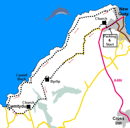
To view route as a dynamic Ordnance Survey map click here. Introduction: Once an important fishing and shipbuilding town, New Quay is now primarily a tourist resort with a pretty harbour and fine beaches. The “easy access beaches” also provided attractive landing spots for smugglers! An annual regatta is held in August. The town has a good selection of pubs, shops and restaurants. The area is well known for its bottlenose dolphins. Normally, when I see such statements, I never actually expect to actually see the promised creatures from the cliffs but amazingly on this walk I did. I gather they are regularly seen so it may be well worth taking binoculars on this walk. Seals are also regular visitors to the local coastline, especially around the tiny hamlet of Cwmtydu, though I did not see any. Autumn is supposed to be the best time. Cwmtydu is a pretty spot with a stream running into the sea. Adjacent to the beach is a well preserved lime kiln which was used to roast imported limestone from Pembrokeshire and Cornwall for use on local fields to neutralise the acidity of the soil (once it had been “slaked” – left in the fields to absorb moisture) and make it more suitable for arable farming. Lime was also used to make lime mortar for building. There is quite a long stretch of lane walking at the beginning of this walk but there is very little traffic and this is an attractive section in its own right. The walk passes two churches. St Llwchaiarn's church in New Quay and St. Tysilio’s church just before Cwmtydu. Both were built in the nineteenth century. Navigation is straightforward, though care is needed to get the right path in some very attractive woodland. There are two or three steep ups and downs on the coast path hence the amber traffic light. The walk starts from the large pay and display car park in New Quay on the A486 running into the town. The best way to get there is to take the A486 from Synod Inn, south of Aberaeron. The car park is then on the right as you come into the town. Start: The car park has two entrances and it is simpler to find the correct way by exiting the top entrance and turn right and cross straight over the A486 into Rectory Square. Proceed to the church and go through the churchyard, anti-clockwise round the church building. Exit the churchyard into a broad track and turn left.
Go through a gate and take the right fork. Go through two gates and keep to the left of the farm buildings, passing between them and the caravan site on a broad track. Follow it to the main access to the farm and turn left (SN 383599). It becomes a tarmac lane which you follow, passing the entrance to the caravan park. You now stay on this lane and the stony track it later becomes for one and a half miles. There are good views seawards along the way.
The track turns right to a group of buildings (Byrlip), which have been turned into houses. The house facing you is called The Stables and the onward path runs down its right hand side and is indicated by an arrow on a post. The path now becomes well enclosed with hedges (SN 368584). After almost half a mile, the path drops down to meet another (SN 368577) at a ‘T’ junction. Turn right, downhill, through the trees, a particularly attractive stretch of woodland. Arrive at another junction of paths by a National Trust sign for Byrlip. There is a multiple way fingerpost here. Turn left following the fingerpost for “Cwmtudu 1 mile” and quickly crossing a footbridge (SN 365577). Turn right.
Cross a second footbridge and turn left up steps. The path emerges at a St. Tysilio church. Follow the path through the graveyard. The church was originally built in 1825 and restored in 1890. A large prehistoric stone was found inside during restoration and the font is 15th Century. The church is Grade II listed.
At the road turn right for a few yards then left across a footpath, starting just in front of the Caerllan farm gate. Note this path does not appear on the map but is a concessionary path on National Trust land. It takes you to a broad stony track where you turn left. On reaching the road, turn right, bearing right at a junction and follow it down to Cwmtydu. As you descend, the coast path, your onward route, is clearly visible climbing the cliffs on the right.
Climb the cliff path to a three way fingerpost then turn left. It is then a simple matter of following the footpath back to New Quay.
You will pass a number of interesting features such as the cove at Castel Bach, with its little island.
There are some steep steps down and up again at Craig Coubal (SN 374594). It was along this section of coast that I saw the dolphins and some unusual rock strata at (SN 379601).
The coast path leads into a lane which goes down into New Quay. At the cross roads, go straight across to join the A486 and right, back to the parking. If you did not do so at the start of the walk, it is worth a diversion to see the pretty harbour.
If you need to buy any hiking equipment/clothing before your trip see the Hiking Store All information on this site is given in good faith and no liability is accepted in respect of any damage, loss or injury which might result from acting on it.
| | |||||||||||||||||

.jpg)
.jpg)
.jpg)
%20St%20Llwchaiarn's%20Church,%20New%20Quay.jpg)
%20Coastal%20view%20from%20the%20road.jpg)
%20Footbridge%20in%20woodland.jpg)
%20St.%20Tysilio%20church.jpg)
%20Cwmtydu.jpg%20(2).jpg)
%20Limekiln%20at%20Cwmtydu.jpg)
%20View%20North%20East.jpg)
%20View%20South%20West%20to%20Ynys%20Lochtyn.jpg)
%20Castell%20Bach.jpg)
%20Beach%20North%20East%20of%20Castell%20Bach.jpg)
%20Steps%20at%20Craig%20Coubal.jpg)
.JPG)
%20Unusual%20rock%20strata.jpg)
%20Approaching%20New%20Quay.jpg)
%20New%20Quay%20Harbour.jpg)