
|
|
|
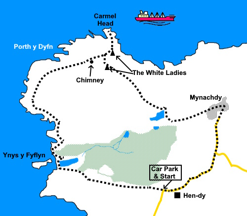
To view route as a dynamic Ordnance Survey map click here. Introduction: This circular walk is in one of the more remote parts of Anglesey and takes you to Carmel Head. It begins with a gentle descent to Fydlyn Beach, a shingle beach alongside the rocky islet of Ynys y Fydlyn which has an interesting sea arch. The OS map shows the beach backing on to a small lake but in the exceptionally dry summer of 2026, this had dried up. At the beach you will notice a footpath skirting round the headland. With hindsight this is probably the easiest way to go but I followed the path marked on the map through the scrub. The gorse made me regret wearing shorts! Please note, a National Trust sign warns that this is private land and that this section of footpath is only open from February to 14 September each year. It is then closed for pheasant shooting. Out at sea, notice The Skerries, a group of small islets which are a breeding ground for sea birds. The islets are obviously a hazard to shipping and therefore have the Skerries Lighthouse originally built in 1759 with various alterations since. It was automated in 1987 but the old lighthouse keepers cottages are still in use by RSPB wardens. The Skerries can be visited by boat from Holyhead. As you approach Carmel Head, you will see a chimney and two triangular concrete structures. The chimney is a well-preserved remnant of the 19th-century Gadair Mine (also known as the Great Carmel's Point Mine or Carmel Head Mine), marking the location of the old mine engine. The mine was an 18th/19th-century copper, lead, and zinc working. It began life in 1756 and there was various mining activity until it was abandoned in 1880 because it was unprofitable. The concrete constructions are known as the White Ladies and are two of three triangular constructions. The third one is on a small island just offshore. Lining up the three of them enabled shipping to avoid the Coral Rock Reef just offshore. These constructions are bigger than they first look as you will discover. Carmel Head itself comprises probably the oldest rocks in Wales, made of Precambrian rocks, the oldest part of Earth’s history. Its geographical importance because of this has made it a Site of Special Scientific Interest (SSSI) There are good views of The Skerries during the walk and in the distance is the Wylfa nuclear power station.
The walk starts at the Mynachdy National Trust car park shown on the OS map (SH 303914) close to the farm Hen-dy. To get there, the easiest route is to turn west off the A5025, (close to Llyn Llygeirien) signposted for Llanfairnghornwy. Pass through this hamlet and follow the road to a ‘T’ junction with a grassy triangle. Turn left here and you will arrive at the car park after half a mile. Note the approach roads are narrow so be prepared for reversing!
Start: From
the car park, take the track leading from its rear. At
a junction of tracks. Bear round to the right. You may have to unhook
an electric fence with the handle provided. The track opens into a rough field. Follow it down and you will come to a post marked with a yellow top. Follow the broad track down to its right and onward to the beach.
Turn
right along the pebbled beach and through a kissing gate. Through
the kissing gate, bear right to follow the faint path through the trees and
scrub, unless you choose to take the headland path (see Introduction). You will arrive at a fenced off area where there is a gate. Do not go through the gate but follow the left of the fence. Near the end of the fence look out for a left turn to work your way to the cliff top path at SH 291919 where you turn right to follow it.
As you near the chimney, you will see a footbridge (SH 297928). Cross this and make your way to the Head itself. Distinctive paths are not particularly clear but it is no real issue. The rocks make a pleasant spot for a picnic.
Return across the footbridge and make your way via the furthest inland White Lady from which the path is obvious, heading roughly South-East.
Follow
the broad track to Mynachdy Farm (SH 309923). There are various electric
fences to unclip and at the last section near the arm, there is a stile to
keep to the left of the fenced track to avoid conflict with cows at milking
time. There are a lot of them! In the farmyard, look out for a three way fingerpost on the left by a ban and turn right here. The rougher track becomes a tarmac lane. Simply follow this back to the car park, avoiding any turns off.
If you need to buy any hiking equipment/clothing before your trip see the Hiking Store All information on this site is given in good faith and no liability is accepted in respect of any damage, loss or injury which might result from acting on it.
| | ||||||||||||||||||
.jpg)
.jpg)

.jpg)
.jpg)
.jpg)


%20Approaching%20the%20beach%20with%20Ynys%20y%20Frydlyn.jpg)
%20Lighthouse%20on%20the%20Skerries.jpg)
%20Ynys%20y%20Fydlyn%20with%20arch.jpg)
%20View%20south%20with%20Holyhead%20Mountain.jpg)
%20View%20North%20on%20attaining%20cliff%20path.jpg)
%20Gladair%20Mine%20chimney%20and%20White%20Ladies.jpg)
%20View%20east%20from%20Carmel%20Head.jpg)
%20A%20white%20lady.jpg)
%20Carmel%20Head%20looking%20out%20to%20the%20Skerries.jpg)
%20View%20from%20the%20lane%20from%20Mynachdy.jpg)