
|
|
|
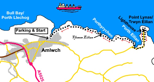
To view route as a dynamic Ordnance Survey map click here. Introduction: This walk from Amlwch Port explores a stretch of the north coast of Anglesey. There is a historic port, an ancient well, a very pretty bay and an unusual lighthouse to see The walk is a ‘there and back’ linear, cliff top walk. I normally prefer circular routes and although if you study the map, it is possible to contrive one here, with some of it on public footpaths, a fair chunk of the return would be on quite a busy lane. On the day I did the walk, it was very hot and I preferred the cliff top return with better sea breezes. It is an easy walk with little scope to go wrong! Amlwch Port is built in a narrow natural harbour and is one of the best preserved mineral exporting harbours in Wales. It was at its peak in the 18th Century, exporting copper from the nearby Parys Mountain mine (which is well worth a visit). Shipbuilding yards evolved on both sides of the port and the dry docks on along the outer wall of the harbour are clearly visible. Just inland from the harbour is a pleasant ‘square’ with a car park and the Adelphi pub which I can recommend for its beer. About half way along the walk, just after crossing a footbridge, is Ffynnon Eilian (‘Eilian’s Well’) at the foot of a rocky outcrop. Like all such places it comes with a legend. It was believed to have healing properties (subject to donation!) and was visited for rituals on Saint Eilian’s day (13 January). In addition to healing you could evidently cast spells on others! It supposedly came into being where a greyhound killed St. Eilian’s pet deer. It is now watched over by a sculpture of who I assume to be St. Eilian. You then come to Porth Eilian, a pretty, secluded bay with a beach and slipway for launching small boats. I expect this is a popular spot for users of a nearby caravan park. There is a handy bench for a picnic spot just before you get there, overlooking the bay. The walk terminates at the unusual Point Lynas lighthouse. I say unusual because as you will see, its lamp room is at ground floor level and it is location on the cliff tops which gives it its necessary height. It also has an unusual castellated design. It is an active lighthouse and you can clearly see the Fresnel lens configuration. A light first appeared there in 1779 and the present building was erected in 1835. The former lighthouse keepers’ cottages are now holiday lets. The walk starts at Amlwch Port. To get there, turn off the A5025 on the south side of Amlwch but follow signs for Amlwch Port not Almwch Town Centre. You will arrive at the parking area by the port. If this happens to be full, there is a little alternative parking by the harbour or cliff top parking by heading towards the harbour and forking right but you would then have to come back on yourself to visit the harbour. Start: From the parking area in the ‘square’, follow the road along to the harbour, indicated by a white on blue sign. Keep left at the next fork to get close to it. As you get to the end of the harbour, follow the Welsh Coast Path fingerpost and you will find yourself at the cliff top car park. Follow the broad gravel track along passing a derelict house.
Just past the house, the path forks. Take the right fork. You now simply follow the obvious coast path.
At SH 466933 you will come to a footbridge alongside which is Ffynnon Eilian (‘Eilian’s Well’) with a handy bench.
Continue to follow the coast path until you reach Porth Eilian (SH 476930). Here you go through a walkers’ gate by a small roundabout. Turn left here and follow the tarmac road for about half a mile.
Not far after a lonely house on the right. Look out for a walkers’ gate on the left of the road just after it (SH 479932), Through this, turn immediately right to follow to the left of the wall. This path will take you on a circuit of the lighthouse to rejoin the road close to the house. From there, retrace your steps to Amlwch Port.
If you need to buy any hiking equipment/clothing before your trip see the Hiking Store All information on this site is given in good faith and no liability is accepted in respect of any damage, loss or injury which might result from acting on it.
| | ||||||||||||||||||
.jpg)
.jpg)

.jpg)
.jpg)
.jpg)


%20Amlwch%20harbour.jpg)
%20Dry%20docks%20at%20Amlwch%20harbour.jpg)
%20Wild%20flowers%20on%20the%20cliffs.jpg)
%20Looking%20along%20the%20cliffs%20to%20Point%20Lynas.jpg)
%20Small%20cove%20en%20route.jpg)
%20Foorbridge%20and%20wild%20flowers%20at%20the%20holy%20well%20site.jpg)
%20Holy%20well.jpg)
%20Looking%20back%20along%20the%20coast.jpg)
%20Telephoto%20shot%20of%20Point%20Lynas%20lighthouse.jpg)
%20Porth%20Eilian.jpg)
%20Approach%20road%20to%20Point%20Lynas.jpg)
%20Ornate%20entrance%20to%20lighthouse%20complex.jpg)
%20Point%20Lynas%20lighthouse%20lamp%20room.jpg)