|
Pen
Hill
Circuit
Starting point and OS Grid reference: 
Carlton-in-Coverdale - On street
parking. (SE
065847)
|
Ordnance Survey Map
OL30
Yorkshire Dales – Northern and Central Areas.
Buy
this map from
List
of OS Maps
Commission
from map sales is used to fund the website, so keeping it free to use.
| |
Distance: 9.4
miles (excluding optional diversions)
|
Date of Walk: 14 March 2012
| |
Ascent:
Descent:
See Walking Time Calculator
|
509m (1670ft)
509m (1670ft)
| |
Traffic
light rating: 

(For explanation see My
Walks page)
| |


For advice on .gpx files see
My Walks page
|

Click
the PDF logo above to give a printable version of this walk without the
photos.
|
To
view route as a dynamic Ordnance Survey map click here.
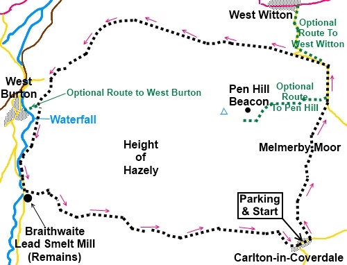
Introduction:
Pen Hill is a distinctively shaped
hill which overlooks Wensleydale to its north and the lesser known Bishopdale to its
west and Coverdale to the south-east. This walk is intended as a circuit
around Pen Hill but there are the options of diversions to the summit
(adding 1 mile each way) and to the villages of West Witton (adding ¾ mile
each way) and West Burton with its impressive village green and waterfall
(adding less than ¼ mile each way and well worth the visit). The walk
provides lovely views of all the dales walked and crosses the bleak Melmerby
Moor.
There are the remains of a beacon on top of
Pen Hill, part of the national network built to warn of a Spanish invasion.
This village starts in the village of
Carlton-in-Coverdale. There are many places in Yorkshire with the name
Carlton and this village is often referred to as Carlton-in-Coverdale to
distinguish it, although it is only shown as Carlton on the map.
You can get there via the exciting road over
Park Rash from Kettlewell or by turning south off the A684 at West Witton,
via Melmerby.
There is a little road walking but the lanes
are quiet.
Parking is on the main street at Carlton-in-Coverdale,
as close as you can sensibly get to the Wesleyan chapel by the phone box
which is where the walk begins.
There are refreshment opportunities at
various pubs in West Witton,
West Burton and Carlton-in-Coverdale.
%20Waterfall%20near%20Carlton.jpg)
Start:
Walk alongside the chapel (SE 065847) following the fingerpost for Melmerby
Moor 1½ miles, along a broad track. Pass a small attractive waterfall on
the left and just after this go right through a gateway continuing to follow
the broad track.
After passing a ruined cottage, turn right.
The path becomes a little indistinct but follow the wall down to
Micklethwaite Gill (SE 063854) where it becomes clearer. Climb the short
stony track over the stream and after going through a gateway, branch off
left. Do not follow the more imposing track straight on.
Through the next gate, keep straight ahead.
As you approach a wall, turn left on to a
more prominent track (SE 064856). Go through another gate and straight ahead
across a broad track – do not be seduced by the white posts indicating
another track to the left.
Cross another broad track keeping straight
ahead by which time you should be in sight of the road. Turn left and walk
along the road. Superb view of Wensleydale now come into view.
%20Pen%20Hill%20From%20Melmerby%20Moor.jpg)
Cross a cattle grid and if you are intending
to visit the summit of Pen Hill, look out for a finger post SE 067869) on
the left immediately after it. The path to the summit is clear, passing to
the right of a small pond. Return to the road the same way.
%20Pen%20Hill%20Summit.JPG)
%20Panoramic%20View%20From%20Pen%20Hill.jpg)
Walk along the road and at the junction by
Pen Hill Farm (SE 068875), turn left signposted West Witton.
If you are intending to visit West Witton,
look out for a fingerpost on the right which takes you down Witton Steeps to
rejoin the road down to the village. Return the same way as far as the
bottom end of this footpath but continue up the road, turning right along
the walled lane on the second hairpin bend as in the next paragraph.
If you have not diverted to West Witton,
continue along the road from Pen Hill Farm and as the road bends sharp right
(SE 062876), keep straight ahead on the walled track signposted West Burton
3 miles. The track offers some lovely views of Wesnleydale and you stay on
it for about that distance ignoring any turns off, including the one at a
fork signposted West Burton via Hudson Quarry Lane. Keep right here.
%20View%20of%20Wensleydale%20from%20near%20West%20Burton.jpg)
As the main track descends through some
trees, look out for a fingerpost hidden amongst the bushes on the left
(SE 023872), “West Burton via Barrack Wood”. Take this path through the
trees and as the wood bends to the left, go through a walkers gate
fingerposted for West Burton and follow the grassy path.
After 100 yards or so, look out for a
fingerpost for Rookwith Bridge and Cote Bridge (SE 021868). Turn left here,
unless you want to visit West Burton and its waterfall, in which case carry
straight ahead and return to this spot afterwards to continue the walk.
%20West%20Burton%20village%20green.JPG)
%20West%20Burton%20Falls.JPG)
Look out for a gateway on the right marked
with a yellow blob (before you get to a barn) and go through this down
towards the beck (Walden Beck). Follow the beck, passing (but not crossing)
a footbridge and follow the sign for Cote Bridge.
At the caravan site, the path gets close to
the waters edge to the right of the field boundary wall. At the road, turn
left (SE 019856).
Pass the entrance to Cote Farm then turn left
following the fingerpost for “Public Bridleway Carlton 3 miles”. Pass
the remains of Braithwaite Lead Smelt Mill with its chimney and short length
of flue, last used in the 1870s.
%20Remains%20of%20Braithwaite%20Smelt%20Mill.jpg)
%20Close%20up%20of%20flue%20at%20Braithwaite%20smelt%20mill.jpg)
The stony walled track rises quite steeply.
Go through a gateway (SE 024853). Here the footpath as shown on the map and
the reality differ slightly. Turn right and follow the broad main track as
it curves left, following the wall. At the wall corner, turn sharp left to
follow the obvious track. A few yards further on, you are back on the
“official” bridleway.
%20Looking%20back%20towards%20Bishopdale.jpg)
As the track reaches the highest point, it
splits. Take the right hand fork. Go through the next gate and turn right.
At Howden Lodge, in a copse of trees, turn
left to join the farm track which takes you back to Carlton. Ignore a left
hand fork towards Pen Hill.
%20Approaching%20Carlton-in-Coverdale.jpg)
If you need to buy any
hiking equipment/clothing before your trip see the Hiking
Store
All information on this
site is given in good faith and no liability is accepted in respect of any
damage, loss or injury which might result from acting on it.
|


.jpg)
.jpg)
.jpg)