
|
|
|
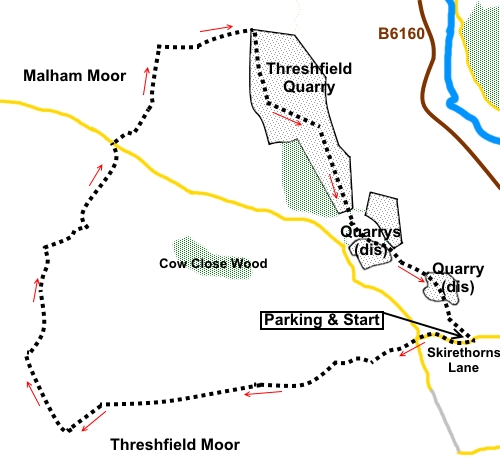
To view route as a dynamic Ordnance Survey map click here. Introduction: If the title of “Threshfield Quarry Circuit” does not inspire you to expect much of a walk, put your prejudice to one side and prepare for a really pleasant surprise. I had the same reservations, until a friend took me on the walk. In fact this is a delightful, easy route along well defined paths/tracks with some stunning views. These include a sweeping vista of Wharfedale, views to Rylstone Ridge, Sharp Haw and Rough Haw and Pendle Hill plus attractive limestone outcrops. The quarry itself provides a dramatic finale of staggering dimensions. Quarrying here has clearly been going on for a long time. 15th and 16th century monastic records refer to lime kilns at Kilnsey and Threshfield but this site began in earnest in 1902. It ceased production in 2000. There are all sorts of plans currently afoot to develop the quarry. These include a visitor and exhibition centre, business space and wildlife haven. This will be a long lasting project, full details of which have yet to be finalised. The walk starts from the entrance to the quarry on Skirethorns Lane at Threshfield where there is a very wide area where you can park safely. To get there, take the B6160 NW from Threshfield (near Grassington). Just after the filling station, turn left on to Skirethorns Lane. The quarry entrance is just short of half a mile from the B6160. Start: From the parking (SD 982639), return to Skirethorns Lane and turn right. Continue along the tarmac, passing the small hamlet of Skirethorns (just one or two houses really, with a stream running along a “village green”) until you reach a ‘T’ junction (SD 978639). Go straight across on a broad track. There is a sign at the junction for “Moss House”. Stay on this track, until you have passed Lane House, ignoring two turns off to the left. No more than 100 yards past Lane House, as the main track bends right, turn off left for “Threshfield Moor, Bordley and Malham” (SD 973637). Follow the right hand boundary of the field. Continue to the top right hand corner of the field, where you go through a double walkers’ gate. Head for the tall upright stone in the field beyond, passing to its right. Head for the gap in the wall ahead. Be sure to look behind you for a sweeping view of Wharfedale. To the left (or right if you are looking back!) you can see Rylstone Ridge on which stands the Cracoe War Memorial.
Pass to the right of a second upright stone. There are posts with yellow tops to guide you. At the top of the field, go through a gated stone step stile and follow the wall on the right.
Cross a broad track and continue straight ahead, now following a fence on the right. You arrive at a broad stony track by a three way fingerpost. Turn right for “Malham Moor Lane” (SD 957633). You now follow this broad, walled bridleway. In the distance to the left is Pendle Hill.
The walled track ends at a farm gate. Through the gate, follow the path as it bends left. At a double set of farm gates, turn left to follow the bridleway fingerpost. As you approach Higher Heights Holes, Great Whernside is visible on the distant horizon. You soon pass an old barn (SD 958647) at Higher Heights Holes with the equally old remains of a lime kiln to its left. In the near distance to the right along here, note the limestone outcrop with the large cave (Height Cave) in which remains of Ice Age animals have been found.
At a four way fingerpost, follow the one ahead for “Kilnsey”. Climb a small rise and continue to follow the bridleway, now marked with a series of posts with blue tops. Cross a road (SD 960650) and continue to follow the bridleway at the other side. Again, there are blue topped posts. Go through a gateway where there is a three-way fingerpost and turn immediately right, following the direction for “Threshfield Quarry” (SD 963656). This does not appear on the OS map as a Right of Way but is permitted as it is across Access Land. There is now a modest climb to a summit and a descent at the other side, following the wall on the right. At the top, there is a limestone pavement of sorts with plenty of rocks where you can sit for a picnic if you wish. When the steep downhill section starts to level out, turn right through a walkers’ gate to the top of the quarry (SD 968657), following the fingerpost for “Threshfield via Quarry Floor”
By the notice board, the path divides. The left one takes you to a viewpoint and you can continue round the quarry top, back to the car. I opted to descend the steps and the clear route to the quarry floor as I think this is more a dramatic route. On reaching the quarry floor, the path continues roughly down the middle of the quarry to the “gorge”. However, it is worth a short diversion left to look at the small lake, hidden behind a banking of stone. Needless to say, look but do not go too near, however inviting its turquoise blue waters might look!
Walk through the quarry and the gorge like section, to take the access road back to the car. As you emerge from the gorge, keep to the right passing to the left of the old stone building. If you need to buy any hiking equipment/clothing before your trip see the Hiking Store All information on this site is given in good faith and no liability is accepted in respect of any damage, loss or injury which might result from acting on it.
| | |||||||||||||||||

.jpg)
.jpg)
.jpg)
%20First%20upright%20stone.jpg)
%20View%20back%20over%20Wharfedale.jpg)
%20View%20south%20to%20Rylstone%20Ridge.jpg)
%20View%20to%20Sharp%20Hwa%20&%20Rough%20haw.jpg)
%20Pendle%20Hill.jpg)
%20Walled%20Lane%20on%20Threshfield%20Moor.jpg)
%20Approaching%20Higher%20Heights%20Holes%20with%20Great%20Whernside.jpg)
%20Height%20Scar.jpg)
%20Old%20Limekiln%20at%20Heights%20Holes.jpg)
%20Approaching%20the%20top%20of%20Threshfield%20Quarry.jpg)
%20Vastness%20of%20Threshfield%20Quarry.jpg)
%20Lake%20in%20Threshfield%20Quarry.jpg)
%20Approaching%20the%20gorge%20in%20Threshfield%20Quarry.jpg)