|
Semerwater
Walk in Raydale
Starting point and OS Grid reference:

Parking
by Semerwater (private charge) (SD 923874)
|
Ordnance Survey Map
OL 30 – Yorkshire Dales Northern and Central areas.
Buy
this map from
List
of OS Maps
Commission
from map sales is used to fund the website, so keeping it free to use.
| |
Distance: 5.4 miles
|
Date of Walk: 27
August 2014
| |
Ascent:
Descent:
See Walking Time Calculator
|
1231ft (375m)
1231ft (375m)
| |
Traffic
light rating:  
(For explanation see My
Walks page)
| |


For advice on .gpx files see
My Walks page
|

Click
the PDF logo above to give a printable version of this walk without the
photos.
|
To
view route as a dynamic Ordnance Survey map click here.
Introduction:
I could open this introduction with the question - is it Semer Water or
Semerwater (answers not required!)? I have seen it written both ways but I
have to make a choice, so I go for Semerwater.
Semerwater is one of only two natural lakes
in the Yorkshire Dales National Park, the other being Malham
Tarn. It was left behind by the melting of the last glacier. Amongst
other wildlife, it contains a healthy number of the endangered species of
white-clawed crayfish.
It has been painted by many artists, the most
famous being JMW Turner. There is an elevated fenced area near the parking
area denoting where he supposedly pitched his easel in 1816.
Semerwater sits in Raydale, a Yorkshire Dale
which few are likely to be able to bring to mind easily. Raydale is a side
dale to Wensleydale, leading from Bainbridge. It is a tranquil dale which
the modern age seems to have passed by.
The walk takes you through the tiny hamlets
of Countersett, Marsett and in my view the prettiest of them all, Stalling
Busk. You also get to see the interesting ruin of Stalling Busk Old Church,
dating from 1722, set apart from the hamlet itself. The interior is divided
by two arcades which run north/south rather than the usual east/west. It
fell into disrepair and ceased to be used in the early 20th
Century and was replaced by St Mathews Church in Stalling Busk itself in
1908/09. The Old Church has some stunning views through its window
apertures.
The walk also takes you along the course of a
Roman Road (Cam High Road), now a walled track. There is no mistaking it as
it is as straight as a die!
En route are lovely views of Raydale,
Wensleydale and if the sun is out, the limestone outcrops positively glow.
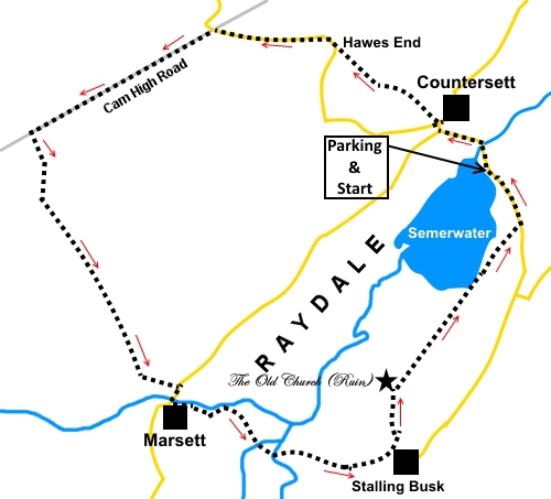
The walk starts from parking areas at the
north-east end of Semerwater. The lake and the parking are privately owned
and you are expected to pay the fairly modest charge (£2.50 for all day
when I visited) to Low Blean Farm nearby, or you may be approached directly
by the farmer. Notices explain. Although you could park for free elsewhere,
using my cost yardstick of more, or less, than a pint of beer, I felt it was
worth the price to start the walk here, as all the climbing then occurs
early in the walk.
The easiest way to find Semerwater is to turn
south-west, off the A684 at Bainbridge. Countersett and Semerwater are
signposted. Immediately after passing through Countersett, turn left for the
lake. The turn is signposted for Stalling Busk but by then the lake is
visible and the way obvious.
%20Semer%20Water.jpg)
Start:
From the car parking (SD 923874) and with your back to the lake, turn left and walk
along the road, over the bridge and up the steep hill. At the junction, turn
right for Countersett and almost immediately, turn left on to the footpath
following the fingerpost for “Hawes End ½ mile” (SD 919878). The first
200 yards or so does not seem to correspond with the OS map ROW, according
to the GPS readings I got!
%20Semerwater.jpg)
%20Semerwater%20Bridge.jpg)
After a few yards, branch off left through a
gateway following the direction of a yellow arrow, up the hill. As you climb
the hill, there are good views of the flat-topped hill of Addlebrough,
behind you.
%20View%20to%20Addlebrough.jpg)
At the top of the field, you reach a footpath
marker post and after going over the little hilltop, drop down to a stile.
Cross it and head up the field to the left of the stone barn. Just past it,
go through the slit stile in the wall on the left and follow the path as it
curves gently right.
As you reach the far side of the field, turn
right to follow the wall. Go through another slit stile and follow the wall
on the left.
%20Looking%20down%20on%20Semerwater.jpg)
The path leads to a gate which, in turn,
leads on to the road at Hawes End (SD 913883). Turn right along the road and
follow it for just under half a mile, when it crosses the Roman Road. You
will see this dead straight track crossing your path, intersecting the road
on a right hand bend. There are tremendous views of Wensleydale along here.
%20Looking%20along%20Wensleydale.jpg)
On reaching the Roman Road (SD 906884), turn
left, following the fingerpost for “Beggarmans Road 3½ miles”.
Stay on the Roman Road for three quarters of
a mile, then turn left, following the fingerpost for “Marsett 1 mile”
(SD 895878) (the footpath in the opposite direction is to Burterset). The
path follows the line of a rocky outcrop at the top of the hill which joins
a wall. You can find rocks in this area for a sandwich stop. Follow the well
trodden path and as you cross the short plateau, good views of Raydale and
Semerwater appear.
%20Raydale.jpg)
%20Semerwater%20and%20Addlebrough.jpg)
The route downhill is clear, heading towards
Marsett below you. It arrives at a stony track where you turn left (SD
901874), to descend to the hamlet. At the tarmac road, turn right.
Cross the bridge and turn left along the
grassy track. Turn left when you reach the stony track, following the course
of the beck. The track drops down to a ford and there is a footbridge to
preserve dry feet! Continue along the track to a second ford and footbridge.
Once over this second bridge, turn left to
part company with the stream (SD 909859). After 100 yards or so, look out
for a gated stile on the right. Cross this and follow the path up the field,
ignoring the little gate next to the stone barn. The field narrows at the
top and almost at its end, turn right through a walkers’ gate and left on
the stony track into Stalling Busk.
At the road, turn left, although before
continuing your journey, it is worth a wander around this pretty hamlet and
St Matthew’s Church.
%20St%20Matthews%20church.jpg)
%20Stalling%20Busk.jpg)
About fifty yards after the church, branch
off left following the finger post for “Ruined Church ¼ mile”
and “Low Blean 1 mile” (SD 917860). The path drops down to the Old
Church with its graveyard, said to contain the bodies of about 750 people.
%20Stalling%20Busk.jpg)
%20Inside%20the%20old%20church%20Stalling%20Busk.jpg)
%20View%20from%20the%20old%20church%20window.jpg)
From the Old Church, it is simply a case of
following the lakeside path to the road and turning left back to the car
park.
%20Approaching%20Semerwater.jpg)
If you need to buy any
hiking equipment/clothing before your trip see the Hiking
Store
All information on this
site is given in good faith and no liability is accepted in respect of any
damage, loss or injury which might result from acting on it.
|


.jpg)
.jpg)
.jpg)