|
Sedbergh
to
Winder
Starting point and OS Grid reference: 
Roadside
parking on Howgill Lane, Sedberg (SD 653923)
|
Ordnance Survey Map
OL19
– Howgill Fells and upper Eden Valley.
Buy
this map from
List
of OS Maps
Commission
from map sales is used to fund the website, so keeping it free to use.
| |
Distance: 6.4
miles
|
Date of Walk: 13 April 2012
| |
Ascent:
Descent:
See Walking Time Calculator
|
1363ft (415m)
1363ft (415m)
| |
Traffic
light rating:  
(For explanation see My
Walks page)
| |


For advice on .gpx files see
My Walks page
|

Click
the PDF logo above to give a printable version of this walk without the
photos.
|
To
view route as a dynamic Ordnance Survey map click here.
Introduction:
This nicely varied walk starts from the self styled “book town” of
Sedbergh, an ancient market town famous for its public school founded in
1552. By some quirk of bureaucracy, it is both in Cumbria and within the
Yorkshire Dales National Park and so is listed under both areas on this
site.
Sedbergh is an attractive spot with narrow
quaint streets and plenty of refreshment opportunities after your walk.
Winder is the attractive grassy hill behind the town rising to 1552 feet
(473 metres). It is one of the Howgills and probably the most easily
accessible. From its summit, there are perfect views of Sedbergh itself,
other surrounding hills and through to the fells of the Lake District.
Our route takes in the summit then descends
to the River Rawthey which is followed to the outskirts of Sedbergh and
through the grounds of the public school back to the town.
One unusual and pleasing aspect of Winder is
that the paths are smooth and grassy which means you can pay plenty of
attention to the views rather than continually looking at where you are
putting your feet!
There are pay and display car parks but also
free street parking on Howgill Lane, more convenient for the start of the
walk, at the junction with a cul-de-sac called Hevera, by a telephone box,
where there is also a handy bench for boot changing.
To get there, turn north off Sedbergh’s
Main Street on to Howgill Lane (next to the Dalesman pub) and follow the
road past the Peoples Hall and children’s playing field until you get to
the phone box.
Sedbergh itself is on the A684 between Kendal
and Hawes.
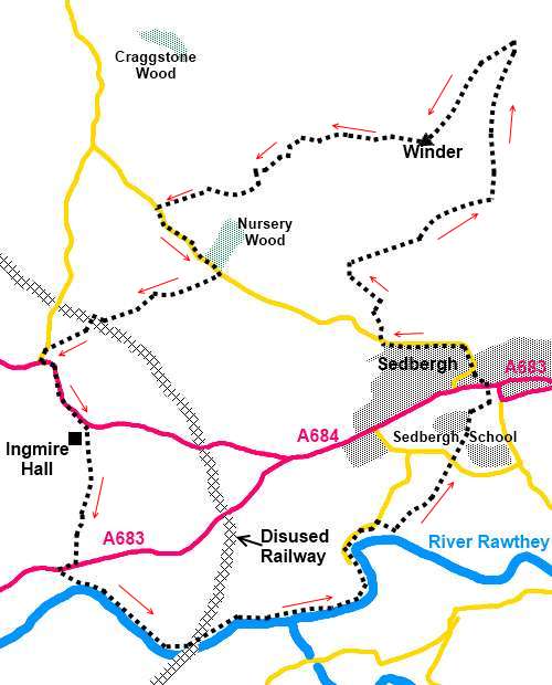
Start:
With our back to the telephone box, turn left and walk along Howgill Lane
for about 100 yards then turn right to Lockbank Farm indicated by a
fingerpost *Permissive Path to the Fell” (SD 652093).
%20Looking%20towards%20Holme%20Knott.jpg)
Go through the farm and a metal gate signed
“Bridleway to the Fell”. Go through the second gate on to the open fell
then turn left but almost immediately, go right to follow the obvious track
(SD 652925) which winds up the fell, turning right when you meet a grassy
track (SD 651927).
%20View%20over%20Sedbergh.jpg)
%20The%20smooth%20paths%20of%20Winder.jpg)
There are a few tracks here and there which
might confuse but essentially just follow the main climbing track until you
reach the broad col, meeting a broad track running along its top (SD
658937). Turn left to the summit, the trig point and orientation plaque (SD
654934). There are marvellous views in all directions and the Lake District
peaks are clearly visible. Sedbergh is laid out before you. It is perhaps
worth mentioning that the “official footpath” on the OS map circles
rather than crosses the summit but the route I describe is clear and well
walked.
%20Summit%20of%20Winder.jpg)
%20Telephoto%20view%20of%20Lake%20District%20fells.jpg)
%20Lune%20Viaduct%20and%20M6.jpg)
At the trig. point, the path forks. Take the
right hand fork.
When the path forks again, keep on the
visibly main path, left (SD 647931). Follow this as it winds down the hill
until you reach a wall. Turn right and follow this along. Ignore the first
gate (which is padlocked and barb wired) and go through the second gate
(with an “Open Access” sign) which is just after a wooden bench (SD
644931). You enter a walled lane which you follow to the road.
Turn left at the road (SD 642930) and follow
it for about ¼ mile until you come to a stile with a finger post “Slacks
Lane 3/8 mile”. Turn right here off the road (SD
645927).
Go down the right hand side of the field to
the gate in the bottom right hand corner and at the farm (Underwinder), turn
left on to the tarmac drive. Follow this down to the road, crossing an old
railway bridge.
%20Winder%20from%20the%20Valley.jpg)
At the road, turn left then almost
immediately left again along the A684 (SD 636922). You need to beware the
traffic here as the road can be quite busy. However, you only follow it for
¼ mile. Pass two large stone gateposts and after another 200 yards or so,
as the road bends left, turn right off the road along a narrow walled track
indicated with a fingerpost “Bridleway to A683 ½ mile” (SD 638919). You
pass the impressive Ingmire Hall with its stone tower.
%20Ingmire%20Hall.jpg)
On reaching a broad track which leads to the
Hall, turn left and follow this to the road (A683) where you turn right.
After 100 yards, go left through a metal kissing gate following the
fingerpost “Birks Mill 1¼ miles” and “Dalesway”
(SD 637913).
The path now follows the River Rawthey. At
the rather impressive old metal railway bridge (SD 643909), it diverts
briefly to cross the disused line then returns to the riverside. Pass the
confluence with the River Dee.
%20River%20Bridge%20over%20River%20Rawthey.jpg)
At Birks Mill, pass and ignore the footbridge
with a fingerpost to Catholes and continue along the tarmac track past the
mill, also ignoring a footpath to Brigflatts. At Birks House on the right
where there is a cattle grid, turn right through a kissing gate to pass in
front of the house, by the garden wall, initially following the fingerpost
for “Millthrop Bridge ¾ mile” (SD 652915).
Ignore a path off to the right, swing round
left in front of Birks House and follow the clear path to the road. Go
across the road and through the metal kissing gate into the grounds of
Sedbergh School. Follow the clear track and once past the school buildings,
ignore the fingerpost for “A684
400 yards” to the left and turn right.
Walk up the left hand side of the church on
the flagged path. This brings you on to Sedbergh Main Street opposite the
Dalesman pub. Follow Howgill Lane to its left back to your starting point.
If you need to buy any
hiking equipment/clothing before your trip see the Hiking
Store
All information on this
site is given in good faith and no liability is accepted in respect of any
damage, loss or injury which might result from acting on it.
|


.jpg)
.jpg)
.jpg)