
|
|
|
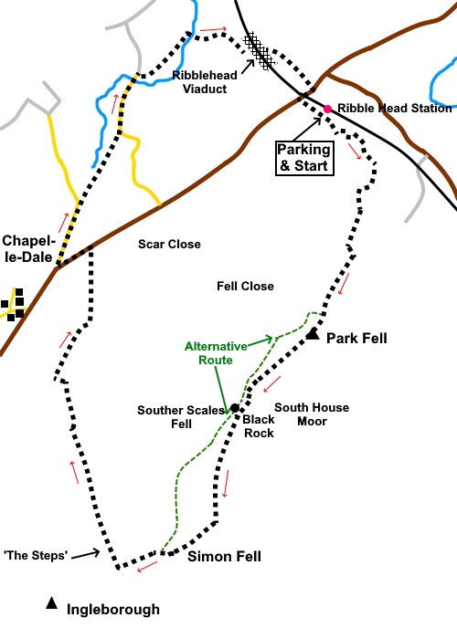
To view route as a dynamic Ordnance Survey map click here. Introduction: Park Fell and Simon Fell are in effect a continuation of the ridge from Ingleborough. Park Fell rises to 1847ft (563 m) and Simon Fell to 2133ft (650 m). Ingleborough tops out at 2375ft (724m). This route is another much quieter, almost secret way of climbing Ingleborough, instead of more popular routes from Clapham or Ingleton. I saw very few people until I got to ‘the steps’ (more about them in a minute). Having visited the summit of Ingleborough many times, I did not do so on this occasion but if you decide to visit, please make sure you have a compass and the knowledge to use it. If cloud comes down, as it is prone to do on this hill, its flat stony plateau, where routes may not be obvious, can be a very disorienting place. On the walk, you can see all the Yorkshire Three Peaks (Ingleborough, Pen-y-ghent and Whernside) and also Pendle Hill in the distance. Part of the reason for the greater solitude on the initial part of this route could be that few people latch on to this way, because it is not shown on the OS maps as public footpaths. This part is Access Land, so you are free to wander but the route described is clear on the ground. Also, a look at the OS map suggests that the way described is blocked by a quarry and non-Access Land. In fact the quarry is now disused and forms part of the Ingleborough National Nature Reserve and a Site of Special Scientific Interest (SSSI). As such, there is a wealth of interesting flora, fauna and limestone landscape to see. The starting point also provides ample parking, away from the normal congestion of Ribblehead. This route involves an extremely steep descent from the ridge to Humphrey Bottom (hence the red traffic light). Although this is an official Public Footpath, it involves using ‘steps’ which have been created from random stones. I put the term in inverted commas because they are somewhat precarious and you need to take great care descending them. It would be very easy to come a cropper if you missed your footing. At Humphrey Bottom there is an attractive area of limestone scenery. To avoid what I would class as an unpleasant road walk, I took a slightly longer return route. Happily, this included passing under the famous Ribblehead Viaduct, a masterpiece of Victorian engineering, on the Settle to Carlisle railway line. It
was built between 1870 and 1874 by as many as 1000 navvies. It is 400m (440
yards) long with 24 arches. During construction the navvies lived in nearby
shanty towns, named Batty Wife Hole, Belgravia and Sebastopol. These were
effectively complete communities with pubs, schools libraries etc. However,
conditions were not particularly sanitary. Between fights, accidents and
disease, hundreds were killed. The viaduct was scheduled to be demolished
due to its deteriorating state in the 1980s but was saved by the then
Transport Minister Michael Portillo (now of the Great British Railways and
This Week TV programmes fame), who subsequently said it was “the greatest
achievement of my political career”. At least one politician with a
concrete achievement! Because
of the steep, grassy ascent up Park Fell and ‘the steps’, I include the
amber/red traffic lights. The
walk starts from the disused Ribblehead Quarry. There is ample parking. To
reach it, turn south-west off the B6255 on to the old quarry road. This is
immediately next to the railway bridge at Ribblehead (i.e. immediately
before it if approaching from the Ingleton side, or immediately after it if
approaching the other way). There are a few potholes so drive slowly! Start: From the parking area (SD 766789), continue along the old quarry track, towards the quarry. As your way ahead is barred by a gate, turn right through a walkers' gate into the Ingleborough National Nature Reserve. When the obvious track divides, the right hand arm heading into the quarry, fork left. The path then bears right before going, clockwise round the left hand top of the quarry (SD 768787). This early part of the walk is marked by posts with green markings.
When the green posts stop, continue to follow the broad stony track through a gate, leading to Park Fell which is ahead of you. Follow the obvious path which is broadly parallel to the wall on the left. At SD 768780, turn left over a stile, then turn right to follow the path on the other side of the wall Just before you get to a wall ahead of you, the path veers left to a walkers’ gate (SD 768776). Go through this and continue to follow the path to the right of the wall. Eventually, at the wall corner, go through a walkers’ gate and turn right. A small sign tells you this is part of the “Ridge Walk”. Turn immediately right again for the trig. point on Park Fell.
You now have a choice. You can either backtrack to the wall corner to follow the path at the other side of the wall, to follow a path SW along the edge of the NW side of the ridge, with views in that direction. This will bring you out at the top of ‘the steps’ where you can pick up the rest of the directions below or do as I did, which was follow the ridge, with views E and SE along the flanks of Simon Fell. Continue along the ridge, with the ridge wall on your right. There are some marker posts with blue pegs. Pass the weathered Black Rock.
At SD 757760 not far below the summit of Simon Fell are some rocks which provide seats for a pleasant lunch stop.
Follow the wall along until just after it turns a corner, cross a stile on the right, then climb the hill, keeping the wall on your left. Ignore the stile to the left immediately after crossing the first. After around a third of a mile, you will close in on the alternative path mentioned previously. Join this and turn left. At SD 747748 you reach the point where the ascent of Ingleborough starts and ‘the steps’ descend to the right. It is just under a steep half a mile to the summit, should you wish to visit, then return to this spot.
Descend ‘the steps’, very carefully! Eventually the steps become a paved path then a stony track which you follow to the road. On the way, at SD 743762 is a large depression in the ground to the right, rather unpleasantly called Braithwaite Wife Hole! I believe there is access to an underground pothole system for those who know what they are doing but for most walkers, keep clear!
It is along this section of the route that you pass an attractive area of limestone pavement, followed by a lime kiln as you get near the road.
At the road, if you are in a hurry, you can follow it for a mile and a half back to Ribblehead. However, given the quantity of traffic on this road and particularly the number of heavy, quarry lorries, I don’t recommend this. In any case, although it is a little further (only about a mile), the following route is a much more pleasant walk and you pass under the famous Ribblehead Viaduct. Turn left at the road for only about three hundred yards, then turn right on a minor road (Philpin Lane) following the sign for “Broadrake Bunk Barn”. Pass Philpin Farm and continue to follow the tarmac until you reach a cattle grid. Immediately before this, turn right on an easily missed footpath along a narrow stony track between the trees, following the Public Bridleway fingerpost. When the path opens into a long, narrow field, walk down the centre of it. When you reach two farm gates, go through the one on the right. Through the next gate, the route is over the stream, with it then on your left. Continue until you reach a tarmac lane and turn left along it (SD 747789), immediately going over a cattle grid.. After a quarter of a mile, the tarmac lane forks. Go right, through a gate, following the fingerpost for “Ribblehead 1¼ miles. As you get close to the farm, cross the stream via a concrete bridge and follow the farm’s access track towards Ribblehead viaduct.
Pass under the viaduct and a few yards further on, turn right at a ‘T’ junction of paths back to the road at Ribblehead. Turn right at the road then left after the railway bridge to return to the parking.
If you need to buy any hiking equipment/clothing before your trip see the Hiking Store All information on this site is given in good faith and no liability is accepted in respect of any damage, loss or injury which might result from acting on it.
| | |||||||||||||||||

.jpg)
.jpg)
.jpg)
%20Park%20Fell%20from%20near%20the%20start.jpg)
%20Looking%20back%20to%20Whernside.jpg)
%20Panorama%20east%20from%20Park%20Fell.jpg)
%20Trig%20Point%20Park%20Fell.jpg)
%20Cotton%20Grass%20by%20tarn%20on%20Park%20Fell.jpg)
%20Black%20Rock%20on%20Simon%20Fell.jpg)
%20Ingleborough%20from%20Simon%20Fell.jpg)
%20View%20along%20the%20flank%20of%20Simon%20Fell.jpg)
%20Limestone%20pavement%20at%20Twisleton%20Scar.jpg)
%20Looking%20back%20along%20footpath%20on%20NW%20side%20of%20Simon%20Fell.jpg)
%20Braithwaite%20wife%20hole.jpg)
%20Limestone%20pavement.jpg)
%20Lime%20Kiln.jpg)
%20Ribblehead%20Viaduct.jpg)
%20Commemoration%20the%20restoration%20of%20Ribblehead%20Viaduct.jpg)