
|
|
|
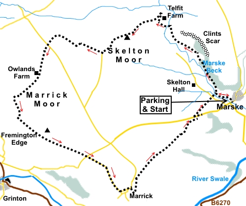
To view route as a dynamic Ordnance Survey map click here. Introduction: This walk from Marske is in an area of Lower Swaledale, generally forsaken for the more dramatic Upper Swaledale in the Reeth, Gunnerside and Muker areas. This is a shame because this walk takes you through a pretty area, starting with the Marske Beck valley before climbing gently over Skelton and Marrick Moors to walk along Fremington Edge. Here there are great views in both directions along Swaledale. As you leave Marske, there is the dramatic limestone outcrop of Clint Scar. I was fortunate to do this walk when the heather was in bloom and a purple haze spread to far horizons. Early in the walk you pass the 17th Century Pillimire Bridge, a listed building which formed part of an important route when the area was important for lead mining. You will pass various evidence of this mining around the route. Further on you cross another distinctive bridge, a packhorse bridge close to Telfit Farm. Marske Bridge where the walk starts dates back to the 15th Century, though has been repaired and widened at various times over the years. The easiest way to get to Marske Bridge is to take the A6108 west out of Richmond for four and a half miles. Look out for a large rough lay-by on the left. Not far after this, turn right over a narrow bridge (Downholme Bridge). The turn is marked for “Marske 1½ miles”. Follow the lane until you get to the bridge at Marske. There is a small area for parking here with voluntary subscriptions for the church invited. From the Reeth direction, turn off the B6270 at Low Fremington, signposted for “Marrick 2½ miles”. As you drive along here, Marske becomes signposted. There are no facilities on the walk, save what you bring yourself. Start: From the parking, cross the road bridge over Marske Beck, following the road sign for Whashton and Ravensworth. Immediately over the bridge, turn left to follow the right hand side of the beck. After not much more than a quarter of a mile, pass and ignore Pillimire Bridge on the left but note this is your return journey route.
Shortly after the bridge, just before leaving the trees, the path bears right and joins a broad track. Turn left along this track. Pass a house called The Orangery. When the track forks, the left arm goes into a field, so keep right. When it forks again, the main track going right, keep left. There are views here across to Telfit Bank.
At a farmhouse, there are three concrete tracks. Take the middle one slightly left then immediately right on to a grassy path. This is fairly clear on the ground. After some farm buildings, the grassy path forks. Keep left, gradually dropping to meet the stream where there is an attractive packhorse bridge (NZ 088024). Cross this and bear slightly left.
Go through a gate and bear right to a farmhouse, going round its boundary clockwise. Turn right along its access track to the next farm, Telfit Farm, where you fork left.
Keep to the main track as it arcs left just after the farm, turning back on itself.
After going through a gateway, cross a broad track and go straight ahead on to Skelton Moor. Keep a look out for the trig. point on the left after about half a mile.
On reaching the end of a road (NZ 072017) turn slightly right to follow the public bridleway fingerpost. Just past a couple of barns (NZ 070018) there are two gates. Go through the right hand gate. At a second gate, turn sharp left following the blue bridleway arrow, without going through the gate or climb over what could be construed as a stile by the gate. After only 150 yards or so, turn sharp right, again following a blue bridleway arrow and passing 100 yards or so to the left of a stone barn. At NZ 626021, you reach the remains of the old lead mining spoil heaps from the Prys Mines. The onward route here is not too clear. The best description is to turn left along the broad track. After a few yards is quite a large heap on the left, before you reach a gate. Turn left before this heap and make your way to the farmhouse visible ahead. Join the road to the left of the farmhouse at Ings Head and go straight across, following the public footpath fingerpost, on to Marrick Moor.
The path is not easy to pick out here. It is slightly left at an angle of about 45° to the road. As you climb the hill, the trodden turf becomes a bit clearer. Continue in more or less a straight line. When the path divides take the right hand path. As a guide, there is a small hump on the far horizon. Head initially for that. As the moor levelled out, the path was pretty obvious when I visited but this is managed moor land and periodic heather burning can cause paths to shift or become less clear. The path leads to a stone wall where there is a stone step stile. Cross and continue in the same direction. You are heading for the broad track across the moor which you can see ahead. This is accessed via the farmyard at Owlands Farm. Follow the track over the brow of the hill and you get to more old mine workings. There is a broad green sward to the left, walk along this until you reach an obvious track on the left at NZ 049005. Follow this through the gate. To the right, Swaledale comes into view. You are now walking through something of an industrial wasteland, looking for a route on the right. I found it impossible to pick out any particular track through the workings. Look out for a row of piles of stones on the right which could almost be path marker cairns although I am not sure they are. Follow this row initially then onward in roughly the same direction, through the tips, until you get to a stone wall. Turn left here (NZ 050001).
Follow this wall for a mile and a quarter along Fremington Edge. There are fine views along here of Swaledale in both directions. Just before the road, you will pass an old lime kiln. At the road, keep straight ahead along the road to Marrick.
At Marrick, take the first left through the hamlet. As the road bends sharp left, turn right following the “Coast to Coast” fingerpost. Just past the old schoolhouse, turn left following another fingerpost for the “Coast to Coast” and “Marske 2 miles” A series of gates, stiles and markers make the next section easy to follow. On reaching a broad track, turn right briefly then left as indicated by yellow markers and a public footpath fingerpost. At a stone barn, the path angles right. The path is clear on the ground.
At a double set of gates, take the left gate. Continue to a broad track and turn right briefly then left, again indicated by yellow arrows. As you descend towards Marske, you will see a farmhouse. The footpath is just to its right, where you join the road. Turn left. I was looking for a stile/gate almost immediately but could not see it so ended up walking a little further to a metal farm gate on the right. Through this, head right, for the left hand corner of the trees. Follow the path down to a stile at the road. Cross and go through the walkers’ gate beyond. This leads to the bridge you passed on the outward journey. Cross and turn right back to the car. If you need to buy any hiking equipment/clothing before your trip see the Hiking Store All information on this site is given in good faith and no liability is accepted in respect of any damage, loss or injury which might result from acting on it.
| | |||||||||||||||||

.jpg)
.jpg)
.jpg)
%20Pillimire%20bridge.jpg)
%20View%20to%20Telfit%20Bank.jpg)
%20Clints%20Scar.JPG)
%20Packhorse%20bridge%20near%20Telfit%20Farm.jpg)
%20View%20over%20Telfit%20Farm.jpg)
%20View%20north%20near%20Telfit%20Farm.jpg)
%20Trig%20point%20on%20Skelton%20Moor.jpg)
%20Lone%20Tree.jpg)
%20Old%20pit%20heaps%20and%20view%20to%20Swaledale.jpg)
%20View%20over%20Reeth.jpg)
%20View%20SE%20along%20Swaledale.jpg)
%20Old%20Lime%20Kiln.jpg)
%20Pretty%20view%20on%20way%20back%20to%20Marske.jpg)