|
Malham
Tarn
Walk
Starting point and OS Grid reference: 
Free
car park by Malham Tarn (SD 894658)
|
Ordnance Survey Map
OL2
Yorkshire Dales – Southern & Western Areas.
Buy
this map from
List
of OS Maps
Commission
from map sales is used to fund the website, so keeping it free to use.
| |
Distance: 8 miles
|
Date of Walk: 1 June 2012
| |
Ascent:
Descent:
See Walking Time Calculator
|
1161ft (354m)
1158ft (353m)
| |
Traffic
light rating:  
(For explanation see My
Walks page)
| |


For advice on .gpx files see
My Walks page
|

Click
the PDF logo above to give a printable version of this walk without the
photos.
|
To
view route as a dynamic Ordnance Survey map click here.
Introduction: To most people, a Malham Tarn walk involves some
combination which including Malham Village and/or Gordale Scar and indeed,
such walks are listed elsewhere on Happy Hiker (see Gordale
Scar and Malham Cove and Bordley
to Malham Cove and Malham Tarn ). As a result, this neglected
but very pleasant and easy walk to the north is much quieter and there is a
very good chance you will meet few other walkers. There is a stretch of road
walking for about 1¼ miles but it is a very quiet, scenic lane with little
traffic – I think three cars passed me. The walk is mostly very
straightforward with only short moderate ascents of less than ¼ mile above
Cowside Beck about half way round the walk and Great Close Hill, should you
follow this option. I have included a yellow “traffic light” for the
ascent above Cowside Beck but it is a marginal yellow/green.
Malham Tarn is
originally a natural lake originally created by glaciers and is the highest
lake in England. Its level was raised just over a metre in the 18th
century by the building of a dam.
There are some
scenic limestone outcrops on view during the walk and it ends with an
optional extra, the opportunity to climb the fairly
low
(465m) Great Close Hill, which provides a great 360° view and one of the
best of Malham Tarn itself. The summit is (or was) a stone cairn and a
Scheduled Ancient Monument but the origin of the circular structure there
now is uncertain.
The walk starts from the free
car park close to Malham Tarn. To get there, turn off the A65 between
Gargrave and Hellifield at Coniston Cold, signposted Bell Busk and Malham.
In the centre of the village of
Malham, turn right where signposted Malham Tarn then left, also signposted
Malham Tarn. Go left at the next junction and the car park is on the right
after about ½ mile.
Public toilets and refreshments
are available in Malham.
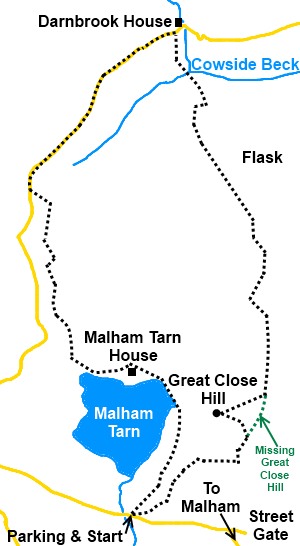
Start: Leave from the car park (SD 894658)
following the fingerpost for the Pennine Way and Malham Tarn ¼ mile on the
path immediately behind the car park and bearing off slightly to the right.
%20View%20Over%20Malham%20Tarn%20to%20Great%20Close%20Hill.JPG)
Two copses of
trees come into view, head between them initially. The path then moves
across to the left hand copse and a third copse appears ahead of you. Join
the broad stony track and turn left on the Pennine Way.
Ignore a path off
to the right at the cattle grid for Middlehouse.
You enter the
Malham Tarn Estate and when you get to the Field Centre, go to its right and
stay on the stony drive – do not turn right on to a tarmac drive.
%20Approaching%20Great%20Close%20Scar.JPG)
Stay on the drive
until you reach a three way fingerpost (SD 889674). Turn right for the
“Pennine Way and Tennant Gill 1½ miles”. Go through a short grassy
valley with a scattering of rocks, then follow the wall on your left,
passing a barn.
Go through a
kissing gate where the path goes slightly left. At a corner of the wall,
turn left, still following a Pennine Way fingerpost and at the end of the
field, go over a stone step stile to follow the obvious track to the road
(SD 885690) where you turn right.
%20Limestone%20Outcrops.jpg)
Stay on the road
for approximately 1¼ miles until the barns belonging to Darnbrook House (SD
899705). Here, turn right following the fingerpost for
“Middlehouse 2 miles”. Walk down the right hand side of the field
and over the stile at the end.
%20View%20towards%20Cowside%20Beck.jpg)
Once over the
stile, walk to the right of the small barn ahead, then slightly left to
reach a step stile at the bottom of the field. Over this and a small clapper
bridge and the path rises straight ahead indicated by a fingerpost for
“Middlehouse 1½ miles”, following the line of a collapsed wall.
Although the “official” footpath diverts right after about 250 yards,
this is access land and it is worth following the line of the wall as far as
the limestone pavement for a good view along the Cowside Beck valley with
its limestone scars.
%20Cowside%20Beck.jpg)
%20Looking%20back%20to%20Darnbrook%20House.jpg)
%20Cowside%20beck%20Valley.jpg)
Turn right then,
to follow the limestone pavement along. When it ends, drop down a few feet
and turn left. At a dilapidated wall, follow it along to the right until you
reach the old gateway (SD 900697) and turn left on a clearer grassy path,
heading for the low point on the near horizon.
As the path
reaches the crest and levels out, head for the gate ahead with the stile
alongside. Go over the stile and bear left. The path then
starts to bend gently right heading towards some limestone cliffs. It
stops short of the cliffs before reaching a wall and
continues to bear right to an abandoned farm amongst trees. You reach
a two way fingerpost with directions to Arncliffe and Darnbrook, neither of
which are of use to us on this walk but passing it confirms you are on the
intended route.
The footpath
passes to the right of the farm and becomes a clear stony path. Follow this
alongside the wall but as the wall bends left, go straight on. After 100
yards or so the path curves left to a ladder stile. Cross this, bearing
right as the path forks but almost immediately, head down the field to the
stile in the fence about half way along its bottom edge.
Cross the stile
and turn right along the farm track (SD 908675)
As you walk along
the track, the nearby hill on the right is Great Close Hill. It is worth the
optional diversion to its top (SD 903668), for the 360° views and probably
the best view of Malham Tarn. There is no specific path to its summit but
this is access land so make your own way there, returning to the farm track
afterwards.
%20View%20over%20Malham%20Tarn%20from%20Great%20Close%20Hill.jpg)
Follow the farm
track to a cattle grid (SD 905663) and after crossing this, turn sharp right
passing to the rear of a copse of trees. The paths now are not particularly
distinct because this is access land and people tend to wander but as you
draw level with another copse on the left, make your way gradually to about
50 yards from its right hand corner and cross the broad stony track, keeping
straight ahead.
On meeting a
clearer grassy track, turn left. There is a low mound to the right with a
scattering of rocks. Head towards its top and from there, the car park where
you started comes into view.
If you need to buy any
hiking equipment/clothing before your trip see the Hiking
Store
All information on this
site is given in good faith and no liability is accepted in respect of any
damage, loss or injury which might result from acting on it.
|


.jpg)
.jpg)
.jpg)