|
Kettlewell
to Langcliffe
Fell
Starting point and OS Grid reference: 
Kettlewell pay and display car park (SD
969723)
|
Ordnance Survey Map
OL30 - Yorkshire Dales Northern and Central Areas.
Buy
this map from
List
of OS Maps
Commission
from map sales is used to fund the website, so keeping it free to use.
| |
Distance: 5.9
miles
|
Date of Walk: 26 February 2012
| |
Ascent:
Descent:
See Walking Time Calculator
|
1166ft (356m)
1164ft (355m)
| |
Traffic
light rating: 

(For explanation see My
Walks page)
| |


For advice on .gpx files see
My Walks page
|

Click
the PDF logo above to give a printable version of this walk without the
photos.
|
To
view route as a dynamic Ordnance Survey map click here.
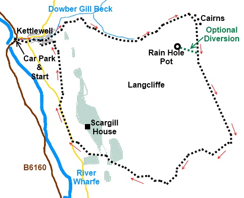
Introduction:
This is a short walk over Lancliffe
Fell, Kettlewell (as opposed to Langcliffe near Settle). It starts with a
moderately steep climb from the village, alongside Dowber Gill Beck, before
swinging round to follow to follow the ridge above the Wharfe Valley, across
and along which there are good views. One issue with this walk is that due
to the use of tractors across the fell in the process of sheep farming, it
is sometimes difficult to be sure which track is the footpath but hopefully
my directions will help.
The walk starts from the picturesque village
of Kettlewell which is on the B6160 between Threshfield (near Grassington)
and Wensleydale.
There is a pay and display car park in the
village centre with public toilets but also a private one across the road,
just by the river bridge, which is half the price (pay at the garage or café).
As a common reference point, this walk starts from the pay and display car
park. There are various pubs/cafes for refreshments.
%20Road%20Bridge%20at%20Kettlewell.jpg)
Start:
Turn left out of the car park (SD 969723) then first right (Middle Lane).
At the maypole, turn left signposted for the church. Walk past the Kings
Head pub and at the road junction, turn right following the Dalesway sign.
Ignore a path on the right signposted
Conistone Road and shortly after it take the public bridleway on the right
indicated by a fingerpost (SD 974724) “Whernside Pastures ½ mile”
%20Old%20Mill%20Building%20at%20Dowber%20Gill%20Beck.jpg)
Pass to the left of a water tank camouflaged
by a stone wall. The path climbs moderately steeply. Go through a gate with
a fingerpost confirming the bridleway route and keep left.
%20Looking%20back%20to%20Kettlewell.jpg)
%20View%20Up%20Dowber%20Gill%20Beck.jpg)
When the track forks, keep left again and
through the next gateway, go left once more following the bridleway sign.
There may well be a multitude of tractor tracks here but stick to the left
hand route.
Go through another gate and round the top of
the little valley you have been following and the track becomes a walled
track though the walls are well dilapidated. Follow this track ignoring any
turns off and as it ends go left then immediately right as indicated by the
fingerpost.
After the path has levelled out, go through
another gate and continue along the obvious track. On the hillside to the
left is the stone building of Hag Dyke Scout Hostel.
On reaching the end of the bridleway marked
by a sign on a gate, climb over the ladder stile and turn right indicated by
the fingerpost for Capplestone Gate. For the next 1¼ miles, you now follow
the wall on the right across Slatepit Rigg, passing below a group of cairns
(SE 993725).
%20View%20across%20Wharfedale.jpg)
%20Cairns%20on%20Slatepit%20Rigg.jpg)
At the first gate on the right, if you do not
mind a 2/300 yard steep grassy descent and return, it is worth a diversion
to see Rain Hole Pot (SD 991722). Go through the gate and turn right at
about 45° until you see a wall ahead of you. Turn left and descend. The
large depression of Rain Hole Pot will soon become obvious. Return the same
way to the main path.
%20Rain%20Pot%20Hole.jpg)
Just beyond the Rain Hole Pot gate are a
number of rocks which make a suitable perch for lunch. There is also a
superb flat rock “bench” just beyond the next gate at SD 997711.
%20Rocky%20Face.jpg)
Go over a ladder stile on the right (SD
998709) and the obvious path goes downhill. After the steepest section ends,
look out for the rock resembling a face on the left. Ignore the path off to
the left to another ladder stile. The path splits. Keep to the left hand
fork.
This is a section where tyre tracks confuse
and the easiest solution is to simply follow the line of the wall on the
right. Continue to follow the wall and as you catch sight of some conifer
trees ahead, the track bends right through a gateway (SD 985704). It
descends to a gateway and stile at the edge of the trees. Go through the
trees, following the fingerpost
for Kettlewell. You are now on part of The Dalesway.
%20View%20Up%20Wharfedale.jpg)
Follow the track to the road and turn right.
Walk along the road, passing Scargill House
and as it bends left, take the footpath on the right through a walkers gate
signposted Kettlewell 5/8 mile. As you are on the
Dalesway, a mixture of obvious stiles, fingerposts and yellow blobs guide
the way. If in any doubt, some power lines will be just to your left all the
way to Kettlewell until you reach a Dalesway fingerpost sending you 90°
left under them. Ignore the gated stile on the right at this point.
Turn right at the broad walled track into the
village, going left at Fold Farm.
If you need to buy any
hiking equipment/clothing before your trip see the Hiking
Store
All information on this
site is given in good faith and no liability is accepted in respect of any
damage, loss or injury which might result from acting on it.
|


.jpg)
.jpg)
.jpg)