|
Hebden
to Grassington and Yarnbury Henge
Starting point and OS Grid reference:

Road
parking in Hebden village outside the Methodist Chapel (SE 027630)
|
Ordnance Survey Map
OL2
Yorkshire Dales – Southern and Western.
Buy
this map from
List
of OS Maps
Commission
from map sales is used to fund the website, so keeping it free to use.
| |
Distance: 6.4 miles
|
Date of Walk: 21 September 2014
| |
Ascent:
Descent:
See Walking Time Calculator
|
780ft (238m)
787ft (240m)
| |
Traffic
light rating:

(For explanation see My
Walks page)
| |


For advice on .gpx files see
My Walks page
|

Click
the PDF logo above to give a printable version of this walk without the
photos.
|
To
view route as a dynamic Ordnance Survey map click here.
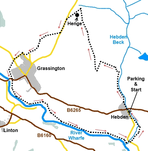
Introduction:
The usual variation on this circular
walk is to walk from Hebden up the course of Hebden Beck and via the old
mine works across to Yarnbury then by one of several possibilities to
Grassington and finally back along the river Wharfe to Hebden. However
because of limited time on the day I went, I needed something a little
shorter (for the same reason, I avoided the temptations of Grassington
centre). I had always been intrigued by the notation of a “Henge” (SE
014654) on the OS map close to Yarnbury and this was an ideal opportunity to
investigate. So often the subject of these historic notations on maps proves
elusive but in this case there actually was something to see. Don’t get
carried away - this is no “Stonehenge” (not even close) but interesting
nevertheless.
The walk also incorporates
the very attractive return walk along the River Wharfe passing Linton Falls.
Refreshments are available
in Grassington at a variety of pubs/cafes, at the Clarendon Hotel in Hebden
and at The Old School Tea Rooms also in Hebden.
The walk starts outside the
Methodist chapel in the small village of Hebden where the road is wide
enough to park and there are benches convenient for boot changing. Hebden is
on the B6265 between Grassington and Pately Bridge. Turn south into the
village off this road and the chapel is on the right after a couple of
hundred yards.
%20View%20Down%20Wharfedale.jpg)
Start:
Facing the chapel, turn right and walk through the village to the B6265.
Cross and stay on the main tarmac lane straight ahead for just over half a
mile. By some holiday cottages, follow the track as it bends left and look
out for a two way fingerpost for Tinkers Lane and Garnshaw (SE 024641). Turn
left for Garnshaw.
Follow the wall along and through the small
walker’s gate at the end. Bear slightly right and go over the small wooden
stile. In the next field and bear right heading towards a gate in the wall,
to the right of which is a stone step stile.
Climb the next field and
cross the wooden stile about half way along the boundary then through the
gated stone step stile in the wall ahead. The path beyond here is a little
indistinct as it crosses rough open pasture but just climb towards the power
pole in the centre of the horizon straight ahead
(if this description leaves you wondering which of two poles is meant, go
for the one to the right).
By the power pole, you reach a broad track
(SE 019641). Go across this to the gated stile ahead. There is a slit stile
here too. The gated stile you want is about 50 yards to its right. Through
this and bear right at about 45 °, to the ladder stile and bear right again
once over it. Go over another ladder stile and head towards the ‘T’
junction of walls ahead. Cross the gated stone step stile just to the right
of the ‘T’.and follow the wall along on your left, crossing another
gated stile.
%20Yarnbury.jpg)
Continue to follow the wall as it turns sharp
left (SE 015653). The farmstead of Yarnbury is visible ahead. After just
under 200 yards, go left through a gated stile and immediately on your left
is the circular mound of The Henge (SE014654).
%20Yarnbury%20Henge.jpg)
Keep straight ahead bearing
right to the corner of the field where there is a stile which puts you on to
the road (SE 012653). Turn left and walk along the road for 450 yards or so
before turning off to the right on to a footpath indicated by a fingerpost
for Grassington (SE 010650).
%20View%20over%20Wharfedale%20and%20Grassington.jpg)
Follow the obvious path
downhill passing to the right of a stone barn. After going through a gate,
the path becomes a walled lane. As it reaches another broad track, go
straight ahead through a stile at which point, the path becomes a narrow
fenced/walled path which opens into Bank Lane. Follow this down to the road
junction and turn right (if you wish to visit the centre of Grassington, you
should turn left here. Afterwards you can either return to this spot or make
your way to Linton Falls via the main Grassington car park – SE 003638).
Back to the intended route
- follow the road round as it bends left passing the house “Scaw Ghyll”.
At the road junction (SD 999644), go straight ahead on to the track
fingerposted for Grassington Bridge.
As you enter a field, head
for the gate half way down the opposite side (SD 998641). Through this, keep
left and follow the narrow strip of field to Grassington Bridge. At the
bridge turn left then immediately right to follow the river footpath
(fingerpost Hebden 2 miles Burnsall 3 miles).
%20Weir%20and%20Sluce%20at%20Linton.jpg)
%20Weir%20at%20Linton%20Falls.jpg)
It is now a matter of
following the river footpath to Hebden. It does briefly exit into a road via
a gated step stile (SE 006634). Turn right past the fish farm to rejoin the
path be the river.
%20Peaceful%20River%20Wharfe%20Scene.jpg)
%20Suspension%20Bridge%20at%20Hebden.jpg)
Stay on the riverbank until
as you approach Hebden suspension footbridge, a path turns off to the left
(SE 026624). Take this to the road and turn right. Go over the river bridge
then turn left in the direction of the fingerpost for Hebden ½
mile. The path passes between the two bungalows (SE 027624).
Keep straight ahead at the
fish farm crossing the stream by the single slab bridge. The path now
follows the left hand bank of Hebden Beck before rising to the road opposite
the Methodist Chapel where you started.
If you need to buy any
hiking equipment/clothing before your trip see the Hiking
Store
All information on this
site is given in good faith and no liability is accepted in respect of any
damage, loss or injury which might result from acting on it.
|


.jpg)
.jpg)
.jpg)