|
Grimwith
Reservoir
|
Starting
point and OS Grid reference:

Free
car park at Grimwith Reservoir (SE063641)
|
Ordnance
Survey Map
OL2 Yorkshire Dales Southern
& Western Areas or
Explorer
298 - Nidderdale.
Buy
these maps from
List
of OS Maps
Commission
from map sales is used to fund the website, so keeping it free to use.
| |
Distance: 4.2 miles
| |
Traffic light rating:

(For explanation see My
Walks page)
| |


For advice on .gpx files see
My
Walks page
|

Click
the PDF logo above to give a printable version of this walk without the
photos.
|
To
view route as a dynamic Ordnance Survey map click here.
Introduction:
This walk round Grimwith Reservoir,
just inside the Yorkshire Dales National Park, is a very straightforward
affair, ideal for a quick two hour or so walk. It is mostly on wide tracks
with just a fairly short footpath section where you might get a bit muddy
after wet weather. The reservoir belongs to Yorkshire Water and is
surrounded by heather moorland, various areas being designated Sites of
Special Scientific Interest (SSSI), Special Areas of Conservation (SAC) and
Special Protected Areas (SPA). The reservoir is Yorkshire Water’s largest
at 0.57 sq. miles.
At the right times of the year, a good
selection of wildfowl can be seen and for this reason, dogs must be on
leads.
The circular route around the reservoir is
very clearly signposted and it is impossible to go wrong. This Introduction
is therefore longer than the walk directions!
There was a smaller reservoir here, built in
1864 by Bradford Corporation but it was enlarged, with work being completed
in 1983, resulting in a raising of the water level by 20 metres.
A sailing club uses the reservoir.
There was at one time a hamlet of Grimwith
and the name means a wood haunted by a ghost or goblin. At the eastern end
of the reservoir is the decaying Grimwith House built in the 19th
century, probably to replace a property destroyed by the first reservoir.
There are records of a farm being at Grimwith since 1302. It is a great
shame something constructive is not done with this property before it is too
late as at the moment, it looks reasonably sound. It believed to have been
occupied until the 1970s.
A hamlet of “Gate Up” also disappeared
beneath the waters. Only a ruin remains.
Grimwith Reservoir is by the north side of
the B6265 Grassington to Pateley Bridge road. The entry road is clearly
signposted by the typical blue Yorkshire Water signs, just short of 2 miles
west of Stump Cross Caverns. There are picnic tables and toilets at the car
park and various benches around the reservoir where you could enjoy a picnic
with views of the water.
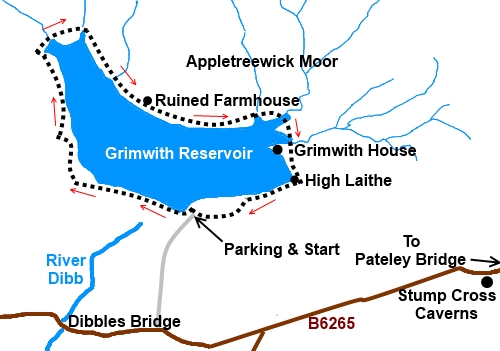
Start:
From the car park take the obvious track to the water’s edge track and
turn left, soon crossing the dam. That is about all you need! Just follow
the route, guided by the fingerposts around the reservoir in a clockwise
direction. If in doubt, turn right! Gates you are not supposed to venture
through are clearly signposted.
%20Grimwith%20reservoir%20from%20car%20park.jpg)
%20Reservoir%20spillway.jpg)
At SE 052647, the route turns left by a barn,
joining another track at a ‘T’ junction. Turn right.
%20Looking%20along%20the%20reservoir.jpg)
About ½ mile later, two bridges take you
over Blea Gill and Gate Up Gill, which feed the reservoir.
%20Winter%20colours.jpg)
%20Reservoir%20from%20Gate%20Up%20Gill.jpg)
At SE 054655, the broad track reverts to a
traditional footpath, returning to broad track at SE059650.
A ruined farmhouse with impressive stone
mullions is at SE 080650 and is all that remains of the hamlet of Gate Up.
%20Approaching%20ruin%20at%20Gate%20Up.jpg)
%20Gate%20Up%20ruin.jpg)
At SE 071649, the track passes between the
main reservoir and a smaller pool which is the end of Grimwith Beck, another
feeder.
%20westerly%20view.jpg)
At SE 072647, you pass the substantial
remains of Grimwith House on a spit of land. You are not allowed a close
look as the area is a nature reserve.
%20Grimwith%20House.jpg)
At SE 072644 there is the well preserved
thatched barn, High Laithe. When the reservoir was being enlarged,
historians realised this was an important example of a cruck barn.
Unfortunately, there seems no provision to let you have a look inside.
%20High%20Laithe.jpg)
%20Grimwith%20Reservoir%20and%20Sailing%20Club.jpg)
You return to the car park about ½ mile
beyond High Laithe.
If you need to buy any
hiking equipment/clothing before your trip see the Hiking
Store
All information on this
site is given in good faith and no liability is accepted in respect of any
damage, loss or injury which might result from acting on it.
|


.jpg)
.jpg)
.jpg)