|
Great
Whernside
Starting point and OS Grid reference: 
Pay
and display car park in Kettlewell (SD 969723)
|
Ordnance Survey Map
OL30 Yorkshire Dales Northern and Central Areas.
Buy
this map from
List
of OS Maps
Commission
from map sales is used to fund the website, so keeping it free to use.
|
Distance: 7.5 or 9.3 miles. See
notes
#
in the text.
|
Date of Walk: 20 January 2016
and 22 February 2019
| |
Ascent:
Descent:
See Walking Time Calculator
|
1802ft (549m)
1800ft (549m)
| |
Traffic
light rating: 

(For explanation see My
Walks page)
| |


For advice on .gpx files see
My Walks page
|

Click
the PDF logo above to give a printable version of this walk without the
photos.
|
To
view route as a dynamic Ordnance Survey map click here.
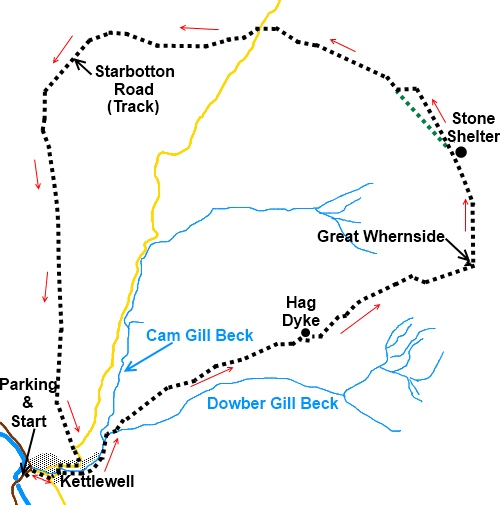
Introduction:
By some quirk of Yorkshire logic, Great
Whernside is smaller than Whernside (of Three Peaks fame) being a mere 704
metres compared to Whernside’s 736 metres. Great Whernside is the
watershed between Nidderdale and Wharfedale and the walk along the ridge
offers good views of both. There are also good views of Pen-y-Ghent with
Ingleborough behind, Whernside and Pendle Hill. On a clear day you can also
see the Lake District hills.
The route passes Hag
Dyke a (supposedly haunted) Scout Hostel on
the fell side administered by the 1st Ben Rhydding Scout Group in Ilkley
which can be hired for groups of young people and will sleep 35 (according
to a poster).
The walk starts from the
picturesque village of Kettlewell which is on the B6160 between Threshfield
(near Grassington) and Wensleydale.
[Note on a revisit to this walk, instead of
returning directly to Kettlewell, I followed the track shown on the OS map
as Starbotton Cam Road down into Starbotton itself, before heading back to
Kettlewell. This is an easy and picturesque alternative and gives you a
chance for refreshment at the excellent Fox and Hounds Inn. See #
below.]
There is a pay and display car park in the
village centre with public toilets but also a private one across the road,
just by the river bridge, which is half the price (pay at the garage or café).
As a common reference point, this walk starts from the pay and display car
park. There are various pubs/cafes for refreshments.
Start:
Turn left out of the car park (SD 969723) then first right (Middle Lane).
At the maypole, turn left signposted for the church. Walk past the Kings
Head pub and at the road junction, turn right.
%20Maypole%20in%20Kettlewell.jpg)
The road follows the course
of the stream (which is on the left). Continue following the stream along
the tarmac road and when the road turns left over a bridge, carry straight
on along a broad track, still following the stream.
As the track bends right,
at a bridge over the stream, turn left over the bridge and immediately right
sign posted Hag Dyke and Providence Pot. Soon, go through a gated stile and
follow the finger post for Hag Dyke along the left hand side of the field.
%20Track%20from%20Kettlewell.jpg)
%20Dowber%20Gill%20Beck.jpg)
At the top of the field, go
over another stile and continue straight ahead. The track swings round in a
loop and arrives at a stone wall. Through the wall the track forks. Take the
right fork (SD 979730). You pass a finger post confirming the public
footpath (SD 981730). Ahead of you, in the fold of the hill is the roof of
Hag Dyke. Head for this.
%20Hag%20Dyke.jpg)
At Hag Dyke (SD 990733)
there is finger post for Coverdale Road (which you will eventually cross)
via Great Whernside. Turn right at Hag Dyke passing through the little gate
marked public footpath to the right of the building then left through the 5
bar gate and follow the steep path up the hill. The top of this steep
section (not enough on its own to warrant a red traffic light!) is a false
summit. When you reach it, follow the path up the hill which is marked at
intervals with yellow topped posts. Behind you, the top of Pendle Hill
appears over the horizon.
%20Pen-y-Ghent%20and%20Ingleborough.jpg)
%20Great%20Whernside%20Trig%20Point.jpg)
The path takes you to the
trig. point (SE002739) amongst a pile of rocks and from here turn left.
Follow the path along the ridge heading for the rocky outcrop ahead (Little
Crags) with what looks to be a large pile of stones which on closer
inspection you will find is a shelter. As you get closer to this, views to
the right (east) stretch to the North Yorkshire Moors.
%20Shelter%20at%20Little%20Crags.jpg)
Just beyond the shelter, a
footpath veers off to the left downhill marked with a yellow topped post (SE
001748). This cuts off a corner but denies views to Nidderdale and Angram
and Scar House reservoirs so ignore this path and continue straight ahead
for about 1/3 of a mile to the corner of two walls
where there is a stile (SD 998752). Cross the stile and follow the path
downhill alongside the wall to the left.
%20Angram%20and%20Scar%20House%20Reservoirs.jpg)
After just over 100 yards,
the wall has collapsed and been replaced by a fence. At this point, a
footpath joins from the left which is the path referred to above which cut
the corner. Our path now turns right.
At a fork, go left. Note
this left fork is fairly faint at first but the path becomes clearer.
Descend to a gate and a gated stone step stile. Go through the gate (or
climb the stile) and follow the path along keeping the wall on your left.
You reach the road by a
fingerpost pointing back the way you have come indicating a bridleway to
Scar House Lodge 4 miles and a road sign to the right indicating the start
of Richmondshire. Turn left along the road and turn right on to the track
close to the cattle grid (SD 986757) (do not go straight on as you reach the
road on a different track).
The path follows the line
of a wall on the left including a sharp turn to the left. After you have
walked about 1 mile from the road, the path forks (SD 971753). Take the left
fork signposted Kettlewell. [#
If you wish to make your return via Starbotton, turn right here, following
the fingerpost for Starbotton. Follow the wide easy track all the way down
into Starbotton. At the road - B6161, turn left along it for around a
hundred and fifty yards. Turn right to follow a fingerpost for Kettlewell.
Cross the River Wharfe via the footbridge, then turn left to follow the
obvious footpath back to Kettlewell.]
%20Looking%20back%20at%20Great%20Whernside.jpg)
After going through a gate,
the track becomes a walled lane. Follow this to join a road on a bend (SD
972725). Turn right and follow the road down into Kettlewell. You join
Middle Lane which you used on the outward journey.
%20Approaching%20Kettlewell.jpg)
If you need to buy any
hiking equipment/clothing before your trip see the Hiking
Store
All information on this
site is given in good faith and no liability is accepted in respect of any
damage, loss or injury which might result from acting on it.
|


.jpg)
.jpg)
.jpg)