|
Beamsley
Beacon
|
Starting point and OS Grid reference: 
Rough parking area on back lane Ilkley to Bolton Abbey (SE 092521)
|
Ordnance Survey Map
OS
Explorer 297 – Lower Wharfedale and Washburn Valley.
Buy
this map from
List
of OS Maps
Commission
from map sales is used to fund the website, so keeping it free to use.
| |
Distance: 7 miles
|
Date of Walk: 6 April 2014
| |
Ascent:
Descent:
See Walking Time Calculator
|
1592ft (485m)
1597ft (487)
| |
Traffic
light rating: 

(For explanation see My
Walks page)
| |


For advice on .gpx files see
My Walks page
|

Click
the PDF logo above to give a printable version of this walk without the
photos.
|
To
view route as a dynamic Ordnance Survey map click here.
Introduction:
Beamsley Beacon (also known as Howber
Hill) at just below 1300 ft (393 metres) is a prominent summit landmark in
the Lower Wharfedale area. It will therefore come as no surprise that it has
featured as a warning beacon for centuries. The name Beamsley Beacon was
first recorded in 1667. What might be more surprising is that archaeological
studies have revealed that a large stone mound was built here about 4,500
years ago probably as a burial place for a Bronze Age local chieftain and as
a territorial marker. This mound is now some 11/12 metres across and about 2
high. There has been “tinkering” over the years and stone may have been
used to construct a guard hut so that the beacon could be lit to warn of
invasion during the Napoleonic War.
The Beacon is popular with trippers who
simply park at its foot and just walk the half mile or so to the top and
return. One cannot blame them as the views from the summit are superb.
However, this walk saves the best till last and provides an easy 7
mile gently climbing approach via Denton Moor, Heligar Pike and Round Hill
before arriving at the Beacon. You get great views south across lower
Wharfedale all the way and equally good ones north, once you attain the
ridge. There some interesting old mile and boundary stones to see on the
way.
The descent from Beamsley Beacon to the car
park is quite steep and rocky hence the amber traffic light but it is not
very long and should not present undue difficulty.
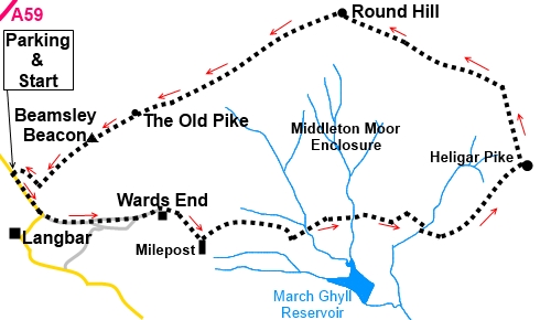
The walk starts from a
remote lane running from Ilkley to near Bolton Abbey via Langbar. From
Ilkley, turn north (right from the Leeds/Bradford direction) at the main
traffic lights and drop down to and cross the river Wharfe. Take first left
on Denton Road and remain on this road as it becomes Langbar Road. Do not
turn off left on to Nesfield Road past the golf course. Stay on this road as
it climbs, twists and turns. Eventually, it levels out and starts to
descend. Keep a look out for a track on the right on a sharp bend,
identifiable because is has a small grassy island and a two way road sign
for Ilkley 4 miles in the direction from which you have come and Bolton
Abbey 2¾ miles in your direction of travel. The parking, such as it is, is half a mile
further on, on the left. Unfortunately, a useful parking area, used by
walkers for decades, by Howber Hill farm, has now been put off limits,
presumably by someone who wants to discourage visitors, so all you are left
with are small lay-by areas.
To get there, from the Bolton Abbey end, head
east from the Bolton Bridge roundabout on the A59 and take first right for
Beamsley. Turn left after a third of a mile, signposted Langbar 1¾ miles.
After about half a mile, cross a cattle grid and, parking, such as it is, is a further
half mile or so on the right.
Start:
From the car park (SE 092521), turn right along the road, passing Beacon Hill House
and fork off left, on to a track at the junction with a grassy island and a
two way road sign for “Ilkley 4 miles” and “Bolton Abbey 2¾” (you
will have passed this if you came from Ilkley) (SE 095518). There is also a
fingerpost for “Badgers Gate ¼ mile”.
%20View%20from%20car%20park.jpg)
The track starts off stony then becomes
tarmac. When it forks, go left (there is a sign for the right fork “Black
Hill House No Through Road”).
%20View%20over%20Addingham.jpg)
The tarmac ends at a converted barn (shown on
the map as Wards End) with a cattle grid and the path goes round the
dwelling clockwise. Follow the stone wall on the right beyond. The wall
curves to the right for the first time. Stick with it, until it curves right
a second time. Here, keep straight ahead following the path which is fairly
clear.
Come to a milestone at a broad track where
you turn left (SE 109516) (if you look at the back of the milestone, the
inscription says Skipton 6 miles). To the SE is March Gill Reservoir.
%20Ols%20Milestone.jpg)
%20View%20Over%20March%20Gill%20reservoir.jpg)
Follow the track as it passes well maintained
stone grouse butts. In the distance you can see a shooting lodge. Follow the
track until it meets another by a gate and turn right for about 150 yards.
Cross the ladder stile on the left (SE 117515).
Come to a metal gate and go through that to
turn right along a broad track.
About half a mile further on, as you approach
a plantation, a “Cup Marked Rock” is shown on the map. I noted a large
rock with three distinct holes to the left of the track. I am not sure if
this is the rock or if someone was trying to split it along the crack but it
is obvious.
%20Cup%20makred%20rock.jpg)
%20View%20towards%20Ilkley%20Moor.jpg)
Keep straight ahead through the gate into the
fairly recently planted (as at 2014) trees. Follow it as it meanders through
them. It bears left before
you go through a five bar gate SE 128516). Cross a stile at the top of the
slope and go straight ahead.
When the path forks, go left. You now have a
closer view of the shooting lodge you saw some time ago.
As you climb higher, as you reach a point
about midway between the shooting lodge and the radio mast in the distance,
you can see Armscliffe Crag on the horizon.
As you reach level with the shooting hut, the
track turns sharp right, just below the top of Heligar Pike, heading towards
the hut. You need to turn left here (SE 137522). This is a more awkward
section in that management of the grouse moor, with periodic burning and
re-growth of the heather means the path may not be clear, depending on how
well it has recently been walked. The map indicates the path should be at
about 345°. In the absence of a precise measurement, the best advice is to
head slightly west of north for the ridge, less than half a mile away,
ahead. It should be visible. Wherever you hit it, you will meet the clear,
well walked path which runs along its length. Turn left to follow the ridge
(SE 136529).
The “golf balls” of RAF Menwith Hill can
clearly be seen and beyond them, depending on the visibility, you may see
the edge of the North York
Moors.
%20Golf%20balls%20and%20Ellecar%20Pike.jpg)
%20Milestone%201.jpg)
%201734%20boundary%20stone.jpg)
After crossing a stile by a boundary stone
with “MM” and “1734” on it, on Round Hill (SE 121536), the path
bears left to Beamsley Beacon. A
sign on the path warns “Strictly No Right to Cycle. Access on Foot
Only”. A word of warning here. There were a number on fingerposts which
were not properly “planted” when I was there. A couple were leaned
against the wall and pointing in the wrong directions. Treat “unplanted”
fingerposts with caution!
%20Broken%20boundary%20stone.jpg)
%20Ridge%20Path%20to%20Beamsley%20Beacon.jpg)
%20Unbreakable%20boundary%20strone.jpg)
Along this next section are good views to
Simon’s Seat and Skipton
Moor.
You soon arrive firstly at The Old Pike (SE
103527) with the remains of its cairn, then Beamsley Beacon itself and the
trig point (SE 099524).
%20Old%20pike%20and%20Beamsley%20Beacon.jpg)
%20View%20North%20from%20Beamsley%20Beacon.jpg)
%20Chelker%20Reservoir%20and%20Skipton%20Moor.jpg)
%20Summit%20of%20Beamsley%20Beacon.jpg)
The descent is fairly steep and rocky. The
car park is visible. Just before you get level with the walled wooded area,
branch off right to descend to the car park.
If you need to buy any
hiking equipment/clothing before your trip see the Hiking
Store
All information on this
site is given in good faith and no liability is accepted in respect of any
damage, loss or injury which might result from acting on it.
|


.jpg)
.jpg)
.jpg)