
|
|
|
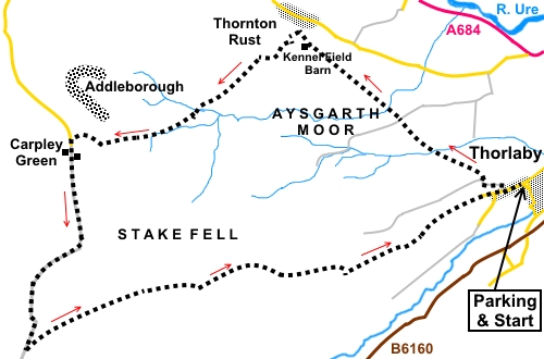
To view route as a dynamic Ordnance Survey map click here. Introduction: This walk from Thoralby is a circuit of Aysgarth Moor
and Stake Fell, on the south side of Wensleydale.
In the process, you get good views of this major Yorkshire Dale and more
minor dales of Bishopdale, a little known dale, Pen
Hill and Raydale, in which sits Semerwater. It
is a quiet area and I saw no-one else at all on this walk, perhaps
surprising as it was June. Addleborough
is a major landmark during the walk and could be summited as part of this
walk if you want an extra challenge! This was used as a lookout station by
the Romans and before them, Bronze Age people buried a chieftain there,
beneath a stone cairn. Remains have been found to support all this. The
walk passes Kennel Field. It is worth mentioning that the barn in this field
was restored by a local group along with the adjacent Mash House. The field
is said to contain over 120 species of plants, including marsh marigold,
meadow sweet, wood anemones, cowslips, early purple orchids, scabious,
ox-eye daisies and flat sedge, which is quite rare. Overall
the walk is straightforward although there are a couple of prolonged uphill
sections which by reason of their length earn “amber” designations. The
walks starts from the car park behind the village hall in Thoralby, which
has an honesty box. To get to Thoralby, turn south off the A684, just east
of Aysgarth or north off the B6160, about a mile south west of West Burton. Start: Turn
left out of the car park and walk along the village’s main street. Look
out for Townhead Farm on the outskirts of the village, on the right and turn
right on the broad track, just before it. The track has a long, concrete stretch which climbs steeply. Go round a right hand bend then, when it turns sharp left and the concrete ceases, go through a double gate on the right and continue up the stony track (SD 996868).
Go
through a farm gate where there is a three way fingerpost fork left,
following the fingerpost for “Thornton Rust “. Go
through a gate in the wall directly ahead, avoiding the second gate and
follow the right hand side of the fence. As
you get to the top left hand corner of the field, there is a stile marked
with a yellow footpath arrow. Cross this and bear left, virtually following
your line of approach. The
next stile can be difficult to spot, which is around thirty yards right of
the top left hand corner of the field (SD 899872). Do not make the mistake
of following a stream into the next field as I initially did! Cross
and turn left and follow the path as it gently climbs the hill, about 50/60°
right of the wall. As you near the top of the hill, note the mass of the
hill, Addleborough, on the horizon. Aim roughly in the direction of its
right hand flank. Go
through a slit stile in the opposite wall (SD 987874). This is a very narrow
stile which is difficult to spot in the stonework. Continue
again in the same line and through two more slit stiles and a gated stile to
arrive at a broad track. Cross straight over through another gated stile,
following the fingerpost for Thornton Rust, along the wall on the right. The path drops down to Gill Beck. Ford this and through the gate at the other side, follow the same line up the bank opposite.
At the top of the bank, there is a two way fingerpost. Follow the direction indicated ahead. Good views of Wensleydale open up.
Cross
another two stiles and continue in the direction indicated by the
fingerposts. Same direction too, after a gated stile and another to the
right of a gate. Just before a stone barn in Kennel Field, come to a three way fingerpost. Turn right following “Thornton Rust 1/8 mile” (SD 974855).
The next few stiles are obvious, in a line and take you to a broad track (SD 972887). Turn left. You get good views of Addleborough.
Follow
this track for half a mile until, not far after crossing a stream via a
clapper bridge, turn left on to a bridleway (SD 967884). When it forks,
follow the bridleway fingerpost. The bridleway is over open ground but is pretty clear on the ground. If in doubt, head approximately towards the left hand flank of Addleborough.
Cross
a ladder stile (SD958876) and follow the path as it curves gently right. At
a fingerpost which says “Permissive Footpath to Addleborough”. Ignore
this and fork left on to the alternative path. Go through a gateway and turn left following the wall. You are now close to the end of Addleborough. Note the farm below you to the left (Carpley Green). The path drops down to the corner of two walls and goes through a gate, exiting into a tarmac lane. Turn left along it (SD 944873).
At the farm, the tarmac gives way to a stony track (Busk Lane). You go through a gate following a fingerpost for “Stake Road 2¼ miles”. This track is now followed follow for almost two miles, climbing quite steeply. It feels never ending!
Eventually,
it levels out and just before a gate, turn left, going slightly back on
yourself, following a fingerpost for “Thorlaby 4 miles” (SD 938847).
This is all access land and you could cut corners but if you follow this
direction, you run less risk of getting lost or disturbing nesting birds in
season. The
route becomes a broad stony track, which continues for some distance. Follow
it but look out for a grassy path off to the left (SD 956855). Follow this
until it rejoins the stony track and turn left following a public bridleway
sign. At
a junction of tracks, with a three way fingerpost, turn right following the
public bridleway fingerpost (SD 967858). Just before the track goes through a gateway, note the fingerpost on the left indicating “Bridleway” (SD969857). Follow this direction, more or less parallel with the wall on the right (i.e. do not go through the gate).
The
bridleway drops down to another gate but do not go through this but turn
left to follow the wall. Go
through the next gate and turn right following another public bridleway
fingerpost. Drop
down to a more distinct track, with three way fingerpost. Turn left
following “Public Bridleway Thoralby”, which takes you back into the
village, passing Townhead Farm which you passed on the outward journey. If you need to buy any hiking equipment/clothing before your trip see the Hiking Store All information on this site is given in good faith and no liability is accepted in respect of any damage, loss or injury which might result from acting on it.
| | |||||||||||||||||

.jpg)
.jpg)
.jpg)
%20Looking%20back%20to%20Thorlaby%20just%20after%20start.jpg)
%20Looking%20back%20to%20Pen%20Hill.jpg)
%20Gill%20Beck.jpg)
%20View%20over%20Wensleydale.jpg)
%20View%20over%20Wensleydale.jpg)
%20Restored%20field%20barn.jpg)
%20Scene%20near%20Thornton%20Rust.jpg)
%20A%20thoughtful%20bridge.jpg)
%20Addleborough.jpg)
%20Approachiung%20Carpley%20Green%20with%20Raydale.jpg)
%20Field%20barn.jpg)
%20View%20down%20Busk%20Lane.jpg)
%20View%20along%20Bishopdale.jpg)
%20Bishopdale.jpg)