
|
|
|
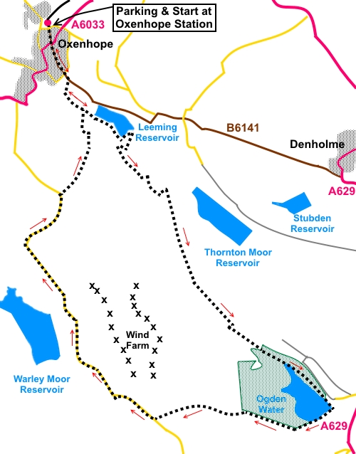
To view route as a dynamic Ordnance Survey map click here. Introduction: This walk from Oxenhope takes you past a series of reservoirs, including the particularly attractive Ogden Reservoir, with its Victorian promenade across the dam. The walk covers some of the same ground as my Ovenden Moor Circuit, a somewhat shorter alternative. You will see several “conduits” on the moors which channel water to the reservoirs. There are some really spectacular views to all points of the compass during this walk. There is a stretch of road walking of about two miles but do not let this put you off. There is little traffic and it is worth it for the views west, including to Stoodley Pike. There is a little uphill work to do after Leeming Reservoir but nothing to warrant concern. Oxenhope is an attractive Pennine village, really an amalgam of several hamlets and has several 17th century buildings, with characteristic stone mullion windows. Peat extraction and quarrying were local industries and it was home at one time to more than 20 textile mills. Leeming Reservoir, the first you pass on the walk, was built in the 1870s to supply them. The textile industry has now disappeared and the remaining buildings have been put to other uses, primarily residential. In more recent times, the 1970s, the village has become more famous for its involvement in the film The Railway Children, by reason of it being one terminus of the Keighley and Worth Valley Railway, one of the first lines to be preserved following the infamous Beeching Axe, which culled supposedly unprofitable lines. It has an attractive station and exhibition centre which are worth a visit and so the description of my walk starts there. You pass close to four main reservoirs but this is reservoir country and others can be seen in the distance. The four are Leeming Reservoir, Thornton Moor Reservoir, Ogden Water and Warley Moor Reservoir. All are owned by Yorkshire Water. Without doubt, the most attractive is Ogden Water, which has been developed into a nature reserve with visitor centre, toilets and café. This provides a potential lunch stop, as does the Causeway Foot Inn if you want to walk the less than quarter of a mile from the reservoir dam, along the access road to the A629. For a picnic stop, there is a handy stone bench at the top of Ogden Clough, mentioned in the directions. As stated above, the walk starts at Oxenhope railway station. To get there take the train! Alternatively, by car, turn off the A629 at Cross Roads on to the A6033, then right at the mini-roundabout in Oxenhope. Alternatively, you can turn off at Denholme on to the B6141 which eventually becomes Station Road in Oxenhope. From Calderdale, there is a spectacular drive over the moors via the A6033 from Hebden Bridge. Turn left at the mini-roundabout in Oxenhope. Parking is on street. There are car parks at the station but these are supposed to be for train users only! August would be a good time for this walk as the views will be enhanced by the heather. Start: From the station (SE 032353), walk back along Station Road, crossing straight over at the mini-roundabout (becoming the B6141). Pass right through the village and past a large mill chimney on the right. Just past the chimney, turn right along Jew Lane (SE 035347).
When the road bends left (uphill being Back Leeming), take the right fork, which is still Jew Lane and marked as a cul-de-sac. There is a yellow footpath arrow marking the direction. Pass Holmefield House and follow the tarmac to its end, going over a “weak bridge”. The road/track becomes a footpath along a row of flagstones. Follow the footpath to the corner of Leeming Reservoir (SE 038343) and go through a walkers’ gate to follow the right hand side of the reservoir.
At the end of the reservoir, go through a five bar gate and turn right along a broad track, passing immediately through a second gate (SE 042341).
Here I was looking for a left turn to follow the Brontë Way but as I missed it and/or it is difficult to locate, I will describe the route taken which is clearer. There are a few paths marked on the OS map here, so there are various options for the same end. The diversion is minimal. Continue through some trees and cross a small stream. As the track bends left, go through a kissing gate on the left (SE 041339). A second kissing gate leads on to open, rough pasture. Climb the rise and after passing a defunct stile, look out for a path to the left (SE 044336) which goes down to a concrete ford across a stream. This was dry despite recent rain when I visited. Follow the footpath beyond as it curves gently right, then left to follow a conduit on the right. A few yards further on is a ladder stile on the right. Cross this and continue straight ahead up on to Thornton Moor.
Follow the obvious path, passing an old truck body. To the right just after the truck, is a three way fingerpost (SE 047334). At this fingerpost, follow the Bronte Way finger (which is also part of the Millennium Way). Your direction is almost south – do not follow the Bronte Way finger post back towards Oxenhope. Note the already improving views behind you towards the Yorkshire Dales, which only get better as you climb. The route becomes a very clear broad stony track. You soon pass Thornton Moor Reservoir on your left.
You reach the top of a small green valley (Ogden Clough), down which flows a feeder stream for Ogden Reservoir. Follow the path down the left hand side to a robust stone bench, which makes a handy picnic spot (SE 054318). There are fantastic views here to Emley Moor and east, where the cooling towers of power stations can be seen in the far distance.
Turn right at the bench to drop down via some stone steps to a bridge. Do not cross but turn left to follow the left hand bank of the stream. This is a very pleasant stretch of the walk. Eventually, the path becomes a more manicured gravel track. Take the second right turn heading down towards the reservoir. You should now be able to catch a glimpse of the water through the trees.
Walk clockwise round the reservoir to cross the dam via “The Promenade”.
From the dam, the broad track climbs steadily offering ever further views, including over Halifax Golf Course to Halifax itself. Ignore any turns off and stay on this track until you exit on to the road at a farm (Top Withens) (SE045307). Turn right along the road. You now have a stretch of road walking of just over two miles. However, it is a relatively quiet road (I doubt I saw a dozen cars) and the views are fantastic to the west, including to Stoodley Pike.
Ignore two turns off to the right as the road descends, a third turn after going round a sharp right hand bend and a fourth signposted for the Calder Aire Link to Bingley. Take the next footpath on the right, just as the road bends sharp left (SE 034334). A sign indicates this is a “Restricted Bridleway” i.e. no motor vehicles allowed. This footpath descends, more or less in a straight line down into the valley. Ignore any turns off. Follow the left hand boundary, to join a walled track, through a gate.
Arrive at a two way fingerpost indicating you have approached on Isle Lane (SE 037341). Turn left to continue to follow Isle Lane. There is a tempting stony track descending to the right after the fingerpost but this is not your route. Continue across the grass to the tarmac section of Isle Lane. Turn right. Follow Isle Lane and at a fingerpost on the left for the Isle Lane Byway, turn left. On reaching a broad track at the bottom, turn left and you are now in familiar territory, part of your outward journey. Retrace your steps to the centre of Oxenhope. If you need to buy any hiking equipment/clothing before your trip see the Hiking Store All information on this site is given in good faith and no liability is accepted in respect of any damage, loss or injury which might result from acting on it.
| | |||||||||||||||||

.jpg)
.jpg)
.jpg)
%20Oxenhope%20Station.jpg)
%20Leeming%20Reservoir.jpg)
%20Looking%20back%20over%20Leeming%20reservoir.jpg)
%20View%20over%20Oxenhope.jpg)
%20Conduit.jpg)
%20Thornton%20Moor%20reservoir.jpg)
%20View%20towards%20Emley%20Moor.jpg)
%20Ogden%20Clough.jpg)
%20Ogden%20Reservoir.jpg)
%20Commemorative%20stone.jpg)
%20The%20Promenade%20Ogden%20Water.jpg)
%20View%20towards%20Stoodley%20Pike.jpg)
%20Return%20to%20Oxenhope.jpg)