
|
|
|
To view route as a dynamic Ordnance Survey map click here. Introduction:
Having walked the Oxenhope Reservoirs
and Oxenhope to Haworth routes, I pretty much thought I had exhausted the
most scenic possibilities from this Pennines village but this short route
came as a pleasant surprise on recommendation. There
is more road walking than I ideally like on a route but its journey around
what is in effect a ‘balcony’ view of the hollow in which Oxenhope sits,
was delightful; hence the title. The roads themselves were quiet. It was one
of those days where the forecast promised cloud in the west and clear in the
east and indeed, the cloud bank could be seen hovering a few miles away but
it kept its distance and a magical trip ensued, with magnificent views. The
steepest part of the walk was the climb out of Oxenhope but not quite enough
to make me give it an amber marking as it was on a tarmac lane! Oxenhope
is an attractive Pennine village, really an amalgam of several hamlets and
has several 17th century buildings, with characteristic
stone mullion windows. Peat extraction and quarrying were local industries
and it was home at one time to more than 20 textile mills. Leeming
Reservoir, the first you pass on the walk, was built in the 1870s to supply
them. The textile industry has now disappeared and the remaining buildings
have been put to other uses, primarily residential. In
more recent times, the 1970s, the village has become more famous for its
involvement in the film The Railway Children, by reason of it being one
terminus of the Keighley and Worth Valley Railway, one of the first lines to
be preserved following the infamous Beeching Axe, which culled supposedly
unprofitable lines. It has an attractive station and exhibition centre which
are worth a visit and so the description of my walk starts there. The
walk starts at Oxenhope railway station. To get there take the train!
Alternatively, by car, turn off the A629 at Cross Roads on to the A6033,
then right at the mini-roundabout in Oxenhope. Alternatively, you can turn
off at Denholme on to the B6141 which eventually becomes Station Road in
Oxenhope. From Calderdale, there is a spectacular drive over the moors via
the A6033 from Hebden Bridge. Turn left at the mini-roundabout in Oxenhope.
Parking is on street. There are car parks at the station but these are
supposed to be for train users only, though no trains were running on the
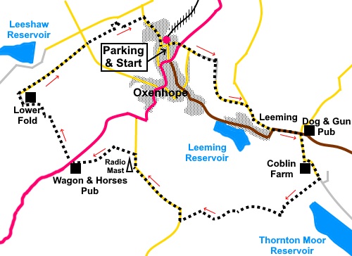
day I did the walk! Start: Emerge from Oxenhope station car park and turn sharp left up the narrow lane (Mill Lane). Follow this up to the main Keighley Road and cross this and proceed up the steep Dark Lane opposite. You follow this for three quarters of a mile. It starts as tarmac and briefly becomes a rougher track before reverting to tarmac again and emerging at a road junction where its name has become to Height Lane. Turn right here (Black Moor Road).
Follow the road to another junction with the B6141 and turn left. This is probably the busiest section of road you will encounter but traffic is still fairly light.
Follow the road until you get to the Dog and Gun pub and opposite this, turn right along Sawood Lane. Stay on this lane as it curves sharp left past the house Sawood Barn and continue to follow it past Coblin Farm, beyond which it becomes a rougher track. Go through a gate keeping straight ahead, following a fingerpost for “Bronte Way” and “Oxenhope 1½ miles” (SE 051337).
Pass the gates to Thornton Moor reservoir and continue to follow the stony track. At SE 041333, cross a conduit, where there is a handy wall for a lunch stop.
Stay on the track, bending left where a right turn for the Bronte Way is indicated by a fingerpost. You leave the Bronte Way at this point, remaining on the track.
Within a few yards, arrive at a gate. Do not go through it but turn right, following an obvious descending track to the right of the wall (SE 047333). Follow this track to the road and turn right along it, indicated by a sign for the “Calder Aire Link to Pennine Bridleway”. Follow the road for just over half a mile, passing the radio mast. About a hundred and fifty yards after the mast, just after passing a gateway, look out for a stone stile on the left (SE 028340). Cross this and follow the wall on the left. In the far left hand corner of the field, cross another stile and follow this path to reach a broad track. Turn left and follow it to the road, emerging next to the Wagon and Horses pub. Turn left along the road for a few yards the turn right following a public footpath fingerpost, quickly joining a steep concrete drive (SE 020339). Follow this down until it curves sharply right. Here, fork left over a stile by a gate. There were some picnic tables on the corner when I did the walk. Once over the stile bear slightly right, probably no more than about 20°. You will reach a slit stile in the wall about a third of the way along the opposite wall, from the left hand corner. Cross and follow the obvious path downhill to a gated stile. Cross the stile and head downhill through relatively newly planted trees. The path is indistinct in places and meanders a little but is broadly parallel with the wall on the left. Follow this path down to reach another wall turn left and follow it to a stile, not far from the corner of the enclosure. Cross the stile on to a walled track and turn left. Continue on the track, crossing a stream via a three plank bridge, to Lower Fold Farm. Immediately past the farm, turn right on a broad track. The track becomes a metalled lane, curving right. There are good views over Leeshaw Reservoir.
Follow the lane (Hawksbridge Lane) for just over half a mile, passing a converted mill and various dwellings, to its junction with a road. Cross straight over and along the drive opposite (SE 022353). At Pin Hill End farm, follow the drive between the buildings and take the narrow walled path straight ahead. Keep straight ahead in the field beyond and then to the right of some cottages. At the end of the cottages, the path bends sharp left then right, between the properties. After crossing a stream, emerge into a wide lane. Turn right, ignoring the footpath sign pointing left. Pass a barn conversion and after going through a ‘Heath Robinson’ kissing gate, follow the obvious path. Turn right on reaching the road to return to the centre of Oxenhope. If you need to buy any hiking equipment/clothing before your trip see the Hiking Store All information on this site is given in good faith and no liability is accepted in respect of any damage, loss or injury which might result from acting on it.
| | |||||||||||||||||

.jpg)
.jpg)
.jpg)
%20Looking%20SW%20from%20Dark%20Lane.jpg)
%20Looking%20towards%20Haworth%20From%20Dark%20Lane.jpg)
%20Oxenhope.jpg)
%20Panoramic%20view%20over%20Oxenhope%20&%20Haworth..jpg)
%20Leeming%20Reservoir.jpg)
%20Graveyard%20at%20junction%20with%20B6141.jpg)
%20View%20over%20Leeming%20Reservoir%20and%20Oxenhope.jpg)
%20View%20along%20track%20after%20Coblin%20Farm.jpg)
%20Reflections%20in%20Leeming%20Reservoir.jpg)
%20View%20NE%20at%20lunch.jpg)
%20View%20to%20Rombalds%20Moor%20on%20the%20horizon.jpg)
%20Leeshaw%20Reservoir.jpg)
%20Panorama%20showing%20much%20of%20the%20route.jpg)