
|
|
|
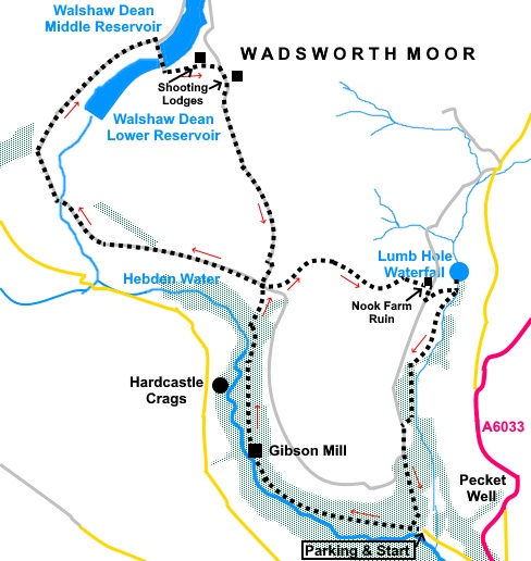
To view route as a dynamic Ordnance Survey map click here. Introduction: This walk from Hardcastle Crags has some overlap with my Haworth and Wadsworth Moor walk and indeed could be partly merged with it to provide an even longer walk. The route starts off at Hardcastle Crags then makes its way to Walshaw Dean Reservoirs between Widdop and Wadsworth Moors, before returning via the very picturesque Crimsworth Dean with the bonus of the beautiful Lumb Hole waterfall. There are some fantastic long distance views en route, including to Stoodley Pike. The route is something of a ‘figure of eight’, so you could treat the first half as a separate short walk to include Crimsworth Dean. Walking/navigation are easy because the majority of the walk follows well defined, broad tracks. Hardcastle Crags is an extensive area of woodland gorge, just outside Hebden Bridge and owned by the National Trust. There is a myriad of footpaths, some running alongside Hebden Water which flows down into the River Calder. The crags are stacks of millstone grit on the side of the valley. Part way along the valley is Gibson Mill. Built around 1800, powered by water from the adjoining dam, it functioned as a mill until 1890 when perhaps unusually, it was transformed into an entertainment centre, with a dance hall, café and skating rink. People walked from as far away as Halifax, to enjoy the dances, which I reckon is about nine miles each way! After World War II, it fell into disrepair until rescued by the National Trust. The area is popular again today with day visitors and Gibson Mill is an interesting visitor’s centre, not least because it is ‘off grid’, by use of solar power, storage batteries and burning wood from the estate. The three reservoirs at Walshaw Dean were built between 1900 and 1913 by Halifax Corporation. They were built by ‘navvies’ who were housed in temporary ‘Dawson City’, a shanty town just outside Heptonstall. A narrow gauge railway was used to transport them and materials/equipment to the construction site using as many as fifteen engines. The route finally drops down to Crimsworth Dean. It is an exceptionally attractive, tranquil and secluded valley with the bonus of a beautiful waterfall at Lumb Hole, evidently popular with wild swimmers (i.e. people who like swimming in natural places not people who are wild!). The walk starts from the National Trust car park at Hardcastle Crags. Note this is the first, smaller NT car park you come to. There is much more car parking just round the corner and if you park there you will have to adjust the directions accordingly. To get there, turn off the A6033 on to Lee Mill Road, three quarters of a mile north of its junction with the A646. The parking is just short of a mile from the junction with the A6033. A few points about access. Firstly, Lee Mill Road (which becomes Midge Hole Road) is narrow and residents’ park cars along here so, if you meet traffic in the wrong places, you may need to do some manoeuvring. Secondly, the junction is easy to miss, particularly if coming from the north, because it is at a very, very (two verys intended!) acute angle. Thirdly, because of the acute angle, if you are returning northwards after the walk, it is likely, at best, that you will need to swing wide and/or possibly need a three point turn to exit. The A6033 can be quite busy so take great care. Start: Leave the car park by the main entrance and turn right along the broad track. If you wish, you can follow a lower path by the stream. Either way, you will reach Gibson Mill which is worth a look. Continue along the broad track after Gibson Mill, passing Hardcastle Crags on the left.
When the track forks, go left and just after it crosses a stream via a bridge, turn right up a narrow footpath marked with a yellow arrow (SD 973310). The path climbs up beside the stream with steps in places. Just after a sharp left hand turn, the path opens into a field. Follow the right hand boundary up to the farm at Walshaw.
Go through the walkers’ gate into the farmyard and immediately left over a stile. Turn left along the lane between Walshaw Lodge and Walshaw Cottage (SD 974314). (NB. If you are doing the shorter walk, this is where you turn right and pick up the instructions at # below). The stony track changes to tarmac and you follow this for almost a mile and a half, crossing over Alcomden Water and eventually reaching a triangular island formed where a tarmac lane joins from the left. Turn right here. You quickly pass a fingerpost for the “Pennine Way” and “Top Withens 3 miles”, which is the direction you want. Half a mile further on, you reach the dam of Walshaw Dean Lower Reservoir. I went clockwise round the dam, crossing the dam of Walshaw Dean Middle Reservoir but you can go either way.
If you follow me, after crossing the Middle Reservoir dam, turn left up a broad, climbing track, soon passing a sign for “Walshaw and Lancashire Moor”.
You pass two shooting lodges and the second one has some low walling which provide a handy perch for a lunch stop.
At a junction of tracks, turn right, just past a sign on the right for “Bigland Way”.
Within about fifty yards, turn left at another junction. The track drops down to a farm (Named as “Top O’Th Field Farm” on an old milk churn) and turn left (SD 974316). # The track arrives back at Walshaw Cottage. Turn left here on the broad track. Almost immediately, fork left following the sign for Crimsworth Dean. Follow the clear track until your way is blocked by a wall, with the open moorland at the other side. Turn right to follow the wall. Reach a walkers’ gate and after going through this, turn right to continue following the wall. Continue following the wall on your right until you reach a right turn (SD 987315), which drops down as a walled track, passing a ruin on the right. Follow it to a ‘T’ junction at which is the impressive ruin of Nook farmhouse. Turn right here.
After no more than two hundred yards, look out for an old walled track, running back at an acute angle to the track you are on and leading to another ruined farmhouse. When this joins your track (SD 989312), turn left down it and pass the ruin. The track divides at SD 992313. There is a post here missing its fingerpost but here is where you turn left to visit Lumb Hole Waterfall. Return to this post and take the footpath which follows the valley (Crimsworth Dean).
The path drops down to meet a broad track at SD 988306, the access track to a house. Turn right here and immediately left, before the gate to follow the obvious footpath. Pass but do not cross an old stone footbridge and follow the stream until you reach a fork in the path, indicated by a yellow arrow on a post (SD 988301). Turn right here. The path climbs gently to meet a broad track. Turn left.
At a junction of tracks, turn left downhill and left again at the next junction to return to the parking area. If you need to buy any hiking equipment/clothing before your trip see the Hiking Store All information on this site is given in good faith and no liability is accepted in respect of any damage, loss or injury which might result from acting on it.
| | |||||||||||||||||

.jpg)
.jpg)
.jpg)
%20Gibson%20Mill.jpg)
%20Hardcastle%20Crags.jpg)
%20View%20along%20Hebden%20Water%20Valley.jpg)
%20Random%20view.jpg)
%20Walshaw%20Dean%20Lower%20Reservoir.jpg)
%20Upper%20Walshaw%20Reservoir.jpg)
%20Walshaw%20Dean%20Upper%20and%20Middle%20Reservoirs.jpg)
%20View%20back%20towards%20Hardcastle%20Crags.jpg)
%20Walled%20track%20down%20to%20Crimsworth%20Dean.jpg)
%20Ruin%20and%20view%20towards%20Oxenhope%20Moor.jpg)
%20Ruined%20farmhouse%20at%20Nook.jpg)
%20Lumb%20Hole%20waterfall.jpg)
%20Lumb%20Hole%20waterfall.jpg)
%20View%20down%20Crimsworth%20Dean.jpg)
%20Footbridge%20over%20Crimsworth%20Dean%20Beck.jpg)