
|
|
|
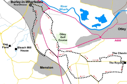
To view route as a dynamic Ordnance Survey map click here. Introduction: This walk takes you to Otley Chevin (Surprise View) with some interesting rocks at the summit at 925 ft (282 metres). it is an alternative to my Otley Chevin walk from Otley. The term Surprise View arises because if you arrive at this point by car, then walk from the car park to the ridge, you cannot see the full view until you are on the ridge and it appears as a “surprise”. It was a sight for a warning beacon and you can make out the hill of another in the chain at Beamsley Beacon across the valley. Evidently a Roman road ran along the ridge linking York (Eboracum) with Ilkley (Olicana). The views across Wharfedale are some of the best in the area. At one time, there was a cottage here, known as Jenny’s Cottage, which became a tea room. It has quite an interesting history and there is an extensive information board about it. Unfortunately, it had to be demolished after falling victim to vandalism. Keep a look out for artwork in the Chevin Area. There are also a number of information boards at Surprise View and a topograph. Long distance views appear at various points on the walk, up towards the Yorkshire Dales, over Airedale and towards Leeds. The walk has the bonus of providing opportunity for a refreshment stop at The Royalty pub, the half way point, after which the walk is all downhill! Start: From the Round House (SE 166464), turn right and walk along Main Street to the roundabout. Cross the A65 by the roundabout and walk along the old Otley Road, marked as a no through road. About 100 yards from the roundabout, turn right on to Eastfield Lane (SE 172461). Follow Eastfield Lane until you reach a gate across it, by a stream. Cross the stream by the plank bridge and follow the path ahead up the field, heading for the diagonally opposite corner.
You arrive at a gate with space to squeeze past on to the golf course. You have to cross the fairway, so take care here to watch out for golf balls and please respect the golfers’ game by waiting for shots to be played if necessary. Head fractionally left of straight ahead to find the exit path from the golf course into the trees at the far side (SE 177449). Follow the path through the trees, climbing slightly until you arrive at the broad path which runs along the course of the old railway line. Turn right and after but a few yards, turn left on a narrow much fainter footpath, which leads up some rough steps.
You arrive at the rear of the Acrecliffe Farm riding stables (SE 178446). Cross the stile, following the yellow footpath arrow. As you get level with the farmhouse, turn right following the public footpath fingerpost. Cross the stile which is about ten yards to the left of the gate entrance to the field. Turn immediately left after crossing the stile, down some steps and follow the clear path to the road, arriving opposite the tall chimney (SE 178445). Cross the road but take great care as the view left is obscured by the bend and traffic sometimes travels (too) fast. On the other side of the road, turn left then almost immediately right to follow the public footpath fingerpost. Note; after going through the gate, the footpath is up the slight bank on the left. The path follows the wall alongside the trees on the left and you continue to follow it after crossing a stile. After the next stile, leave the wall behind and continue along the edge of the trees to arrive at a gate with a gap stile alongside. Go through this and do not go to the left of the fence. Follow the hedge on the right.
When the hedge ends, keep ahead in the same direction. Go through a squeeze stile and follow the fenced section of footpath to the road (SE 187443).
Turn right along the road and then left at the road junction. Walk along the road and after just over a quarter of a mile, at the next road junction, turn left (Yorkgate). Continue to follow the road for a further third of a mile, then turn left through a squeeze stile following the public footpath fingerpost for “Chevin Forest Park” (SE 193440).
Cross the field and at the far side, go through another squeeze stile and turn right. Follow the path to the left of some large rocks then continue straight ahead below a line of rocks.
After passing all the rocks, the path climbs gently to the right to a wall. Follow this along. There are good views to the right and on a clear day, the Emley Moor TV mast is clearly visible.
Ignore a prominent path off to the right and keep straight ahead, passing a fishing pond below you on the right. When you reach a fork at the corner of a wall, go right. The path passes to the right of the summit rocks on Otley Chevin and Surprise View, with its topograph and information boards. Turn right through the car park then left at the road to The Royalty (pub).
The route continues through the pub car park and over a stile at the far side. Follow the obvious footpath to another stile. Cross this and head for the far right hand corner of the field beyond. Cross the stone step stile in the corner of the field and follow the wall on the left. Squeeze past a gate and on joining a broad track at a corner (SE 204435), turn right to follow it, ignoring a stile on the right you soon reach. Follow the track for just over half a mile. There are good views across Airedale along here. When you reach a ‘T’ junction of tracks, turn left, ignoring the public footpath on the right almost immediately (SE 196435). Follow the track as it curves left past the farm and on arriving at the road, turn right. Walk along the road, passing the quarry and ignoring a prominent ladder stile on the left which is private. In less than a quarter of a mile, after passing a stone-built, castellated pumping station, turn left on a broad track following a public bridleway fingerpost (SE 191434). There is also a sign here for Bracken Croft Farm.
Stay on this bridleway, ignoring a public footpath off to the left, until you reach the road (Netherfield Road). Continue on the bridleway, straight across the road.
The bridleway is a tarmac drive to a house at this point. Follow it and turn off to the right of the house (SE 184434). Cross the field and go over a stile, then head to the far left hand corner of the next field. Cross another stile here and go straight ahead to a kissing gate after which, follow the dilapidated wall on the right. Through a gateway, head slightly left, under the power lines, to the road. Go straight across the road and down the broad track opposite following the public footpath fingerpost. Follow the track past the houses and as it bends right, take the footpath off to the left over a stile (SE 181443). The route of the path is now clear, via a couple of stiles, crossing a stream and arriving at the road. Turn left and right at the roundabout. Walk down the road for just over a quarter of a mile, passing the entrance to the Homestead Estate. Turn left along Carlrayne Lane (SE 174445). The lane narrows to a path. Follow it along, ignoring any turns off. Cross the railway bridge to a broad track and turn right. At the road junction by the postbox, turn right. Walk along the road and over the railway bridge, where the road becomes “Menston Old Lane” and descends towards Burley. Turn left off the road at a public footpath fingerpost, crossing a stile (SE 168449). Note; the yellow arrow on the stile is a little misleading, as you keep straight ahead in the fenced area until it turns into a field. Follow the right hand boundary of this field initially but as you approach the stream, head left to a footbridge. Cross this and head for the far left corner of the field. Cross the stile on the right and climb some rough steps to a track running along the disused railway route. Turn left then almost immediately right, to descend some more steps. The path arrives at a road (Holme Park) turn right, then immediately left to follow the footpath indicated by a public footpath fingerpost. At the next road (Sandholme Drive), go straight across. Ignore a path off to the left and continue to follow the beck. Arriving at the end of a cul-de-sac (Jumb Beck Close), walk along the end of it and turn left where indicated by the fingerpost. At the bridge, cross it then turn right. You reach the junction of Prospect Road and St Phillips Way at a corner. Proceed along St Phillips Way. At the ‘T’ junction with Langford Lane, turn left, then right along Grangefield Avenue. Then turn left along Grange Road back to Grange Park and the Roundhouse. If you need to buy any hiking equipment/clothing before your trip see the Hiking Store All information on this site is given in good faith and no liability is accepted in respect of any damage, loss or injury which might result from acting on it.
| | |||||||||||||||

.jpg)
.jpg)
.jpg)
%20Burley%20Moor%20from%20Eastfield%20Lane.jpg)
%20Otley%20Chevin.jpg)
%20Wild%20garlic%20on%20the%20old%20railway%20track.jpg)
%20View%20back%20to%20Burley.jpg)
%20View%20Over%20Otley.jpg)
%20Looking%20down%20Yorkgate%20to%20Menston.jpg)
%20Large%20Rocks.jpg)
%20View%20to%20Almscliff%20Crag.jpg)
%20Emley%20Moor.jpg)
%20Rocks%20at%20Surprise%20View.jpg)
%20Artwork%20at%20Surprise%20View.jpg)
%20Castellated%20pumping%20station.jpg)
%20Descending%20towards%20Menston.jpg)