
|
|
|
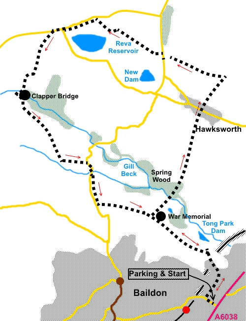
To view route as a dynamic Ordnance Survey map click here. Introduction: This walk from Baildon is an easy, circular walk. There is not a great deal more to say except that it offers good views over Airedale and Wharfedale with relatively little effort. Indeed, Tong Park Cricket Club which you pass fairly early in the walk is regarded as one of the most picturesque in the area. The walk passes through Spring Wood where bluebells and wood anemones blossom in spring. Paths are well defined. It is a walk ideal for accessing by public transport, specifically rail, as it can start from Baildon railway station. If travelling by car, you can park on Roundwood Road. However as this is quite a busy road, I parked on Roundwood Avenue. To get to Roundwood Avenue, turn North West off the A6038, between the junction with the B6151 (traffic lights) and the turn for Esholt, on to Roundwood Road. Roundwood Avenue is then first on the right. For other walks in the Baildon area, see West Yorkshire Walks. Start: From Roundwood Avenue (SE 166395), walk back to Roundwood Road and turn right up the hill. From the station, exit through the car park on to Ridgewood Close, turn right and right again on Station/Roundwood Road. Turn off Roundwood Road on to Park Lane. Along Park Lane, look out for two stone houses on the left and turn left, immediately after them, along a footpath indicated by a public footpath fingerpost. Follow it, as it curves round in front of a long row of stone terraced houses. At the road, cross and follow Lonk House Lane. At the end of the lane, cross a stone stile at which point the route becomes a concrete track. As this curves right, branch off left on an unmade footpath by some iron railings, which are round a war memorial (SE 166401). This commemorates 20 men from Tong Park, who dies in World War I and 2 who died in World War II.
On reaching the broad track by the war memorial, turn left. Below you are Tong Park Dam and Tong Park Cricket Club.
After crossing a stile into a large field, just keep straight ahead as the track peters out. When you reach a wall, ignore a stile and turn right, keeping the wall on your left (SE 159405). Continue in a straight line down to a pretty beck in Spring Wood. Ford the stream as best you can and ascend the bank opposite. When the track forks, take the right, ascending path (not the lower level through the trees).
Exit the trees via a stone stile and follow the left hand field boundary. As you get to the end of a stone wall, cross a stile, indicated by a yellow footpath arrow and turn left along the very edge of the golf course, obviously keeping a weather eye open for flying golf balls.
Beyond the golf course, follow the left hand field boundaries, over a few stiles. On arriving at some garages, follow the footpath between them to the road, cross it and follow the footpath opposite, indicated by a fingerpost. Stay on this path, ignoring a permissive path off to the right through the woods. At the end of the trees, go through a walkers’ gate and follow the footpath - about 30° right. Follow the path down until it meets a stony track and turn left (SE 168422). There are good views here over towards Otley Chevin.
Follow the track to the road, turn right for fifty yards or so, then left following a public footpath fingerpost over a wooden bridge type stile, on to a tarmac drive. Follow the tarmac to the end then turn right over a stile. The route is fairly clear over open country, with the odd stile to guide you. It passes through a patch of gorse and past this, there are a few rocks above you to the right which can provide a pleasant lunch stop. The route continues along to the right of the fence, by Reva Reservoir.
Go through a walkers’ gate to join the access track to the reservoir. Follow it to the road but just before the road, turn left through a kissing gate. This short stretch of path minimises the time spent walking along the verge of this busy road. When the path emerges on to the road, turn left along it. Pass the road junction, ignoring the two footpath signs either side of the road and continue a further hundred yards or so. Just as you get to a “Road Liable to Flooding” sign, turn left along a broad track indicated by a public bridleway fingerpost. At the farm, turn right off the track (effectively straight on) through a gate and follow the right hand boundary of the field. The bridleway becomes a walled track, and you cross Gill Beck via a clapper bridge, at SE142420.
At a ‘T’ junction with another broad track, turn left and follow this for around three quarters of a mile, exiting on to the road, where you turn right. A street sign as you exit indicates you have been walking on Sconce Lane. Follow the road for only a short distance, to just past some stone built houses, where there is a parking area on the left. Leave the road here at the entry for Low Springs Farm, to follow a footpath which runs alongside/parallel to the road. Follow the path to the corner of a wall (SE 152407) and turn left here, just before a stone and whitewashed house (at one time a pub/restaurant). Go through a stile into a large field. Continue in the same direction and over another stile. Go through a gateway next to a ruined barn and follow the fence on the left. Stay on this track ignoring any turns off. You arrive back at the war memorial. Turn right here to retrace your steps to the start. If you need to buy any hiking equipment/clothing before your trip see the Hiking Store All information on this site is given in good faith and no liability is accepted in respect of any damage, loss or injury which might result from acting on it.
| | |||||||||||||||||

.jpg)
.jpg)
.jpg)
%20War%20memorial.jpg)
%20Tong%20Park%20dam.jpg)
%20Sandstone%20outcrop%20on%20Baildon%20Moor.jpg)
%20Gill%20Beck%20running%20through%20Spring%20Wood.jpg)
%20Baildon%20Moor.jpg)
%20View%20over%20Wharfe%20Valley.jpg)
%20View%20to%20Otley%20Chevin.jpg)
%20Reva%20Reservoir.jpg)
%20Clapper%20Bridge.jpg)