
|
|
|
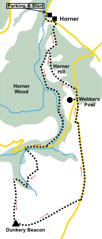
Introduction: Dunkery Beacon is the highest point in Exmoor at 1,705ft (519m). This route provides a lovely walk with distant views, as you would expect from any hill with the title “beacon” in its name. On a clear day, you can see Dartmoor, the Quantock Hills, the Welsh coast across the Bristol Channel and other Exmoor Peaks such as Selworthy Beacon. It is also a walk through ancient deciduous woodland, so much more pleasant then plantations of pine trees. Along the way is a section by a babbling stream, East Water. As with any woodland walk in popular areas, there are footpaths in all directions and it is easy to get the wrong one. However, the route is reasonably well signposted, or has obvious turning points, even though I got it wrong at one point initially. The summit is marked with a massive cairn, with a plaque commemorating the passing of the hill to the National Trust. Alongside the cairn is a topograph with a plate identifying various landmarks. There is one long section of road walking of almost one and a half miles but it is all downhill, the views are worth it and traffic is very light. Some of the walk is part of the Coleridge Way, which celebrates the local landscape which inspired the poet Samuel Taylor Coleridge (1772 -1834) to write some of his most famous works. When you are on these sections, they are marked with a feather (“quill”) on posts/signs. The walk starts from a large free car park at Horner. To get there, turn south off the A39, just east of Porlock.
To
view route as a dynamic Ordnance Survey Start: From the car park, return to the road and turn left. Ignore the path going off by the National Trust toilets. Follow the road round the bend, passing the Horner Vale Tea Rooms. At the corner, is a multi way fingerpost. Follow the yellow feather sign (actually a “quill” representing the Coleridge Way). Exit the village and just after passing Horner Mill, turn right at a fingerpost along a wide, stony bridleway signed “Permitted Bridleway Webbers Post 1¼ miles”. Again, this bears the ““quill”” sign (SS 899454).
Ignore a red arrow sign at the first bend and immediately after going through a tall gate, turn right. The track climbs quite steeply, through attractive deciduous woods to a ‘T’ junction, where you turn right (SS 899450). You quickly come to a three-way fingerpost. Keep straight ahead following “Windsor Walk”. After a few yards, there is a great view over Horner Woods to the sea, with a bench from which to admire it.
At a four way fingerpost, keep straight ahead following “East Water”.
The path drops down to a broader track by the water (SS 900437). Turn left, staying on the route which follows the river. You pass a fingerpost pointing in this direction for “Stoke” Pero and “Priests Way”. The route crosses the river several times via footbridges, eventually exiting on to a road at SS 898430. Turn right.
After a quarter of a mile, turn left off the road, crossing a footbridge (SS 893430) and follow the path up through the trees to open moor land to meet another path at a ‘T’ junction. Turn right (SS 896426). The path follows the contour of the hill before dropping down into a little valley where East Water starts. Follow the obvious path at the other side and quickly reach a junction with another path (SS 891424). Turn left to make your way to the top of Dunkery Beacon. Its summit is marked with a huge cairn and just below is a topograph, picking out various landmarks. The cairn also has a plaque marking the handing over of the land to the National Trust in 1935 (SS 891416).
The onward route is the well used path starting opposite the National Trust plaque (direction 118° magnetic). There is another path which drops lower down the hill but staying on the upper path means you get views both sides of the ridge.
Follow the path to the road and turn left (SS 904420), where the excellent views continue as you drop down the hill. On a hillside in the distance, there is a gleaming white church, which is the Church of All Saints, at Selworthy.
Webbers Post (SS 902439) is marked by a large rough parking area on the left, just before a road junction and is basically just a viewpoint back towards Dunkery Hill, albeit a very nice one. You have to cross another road leading to the aforementioned junction to get to it.
Continue down either road until you reach a second parking area. From the rear of this, take a well “manicured” gravel path described by signs as an “easy path”.(which it is, at least for a while. There are some “chain saw sculptures” along this path.
Follow the path until you reach a three way fingerpost. Turn right following “Permitted Bridleway to Horner”. You also soon pass a ““quill” sign”. At SS 899444 pass a Jubilee Hut dedicated to various people who have helped the Exmoor Society.
Just after the hut is a three way fingerpost. Continue in the same direction, following the ““quill”” sign. When the path splits, keep left following a similar sign. You reach a ‘T’ junction with a three way fingerpost at which you joined the Windsor Way on the outward journey. Turn right to retrace your steps to the parking area. If you need to buy any hiking equipment/clothing before your trip see the Hiking Store All information on this site is given in good faith and no liability is accepted in respect of any damage, loss or injury which might result from acting on it.
| | |||||||||||||||||

.jpg)
.jpg)
.jpg)
%20Fingerpost%20showing%20the%20Coleridge%20Way%20quill.jpg)
%20View%20just%20after%20joining%20the%20Windsor%20Walk.jpg)
%20View%20over%20Horner%20Wood.jpg)
%20First%20footbridge%20mentioned%20in%20the%20text.jpg)
%20Panorama%20during%20ascent%20of%20Dunkery%20Hill.jpg)
%20Bench%20with%20a%20view%20on%20Dunkery%20Hill.jpg)
%20View%20from%20Webbers%20Post.jpg)
%20Chainsaw%20Sculptures%20on%20Horner%20Hill.jpg)
%20Hut.jpg)