|
Long
Mynd Walk
Starting point and OS Grid reference:

Church
Stretton, National Trust pay and display car park
(SO 445944)
|
Ordnance Survey Map
OS
Explorer 217 The Long Mynd and Wenlock Edge.
Buy this map from
List
of OS Maps
Commission from map sales is
used to fund the website, so keeping it free to use.
| |
Distance: 7.5
miles
|
Date of Walk: 7 May 2013
| |
Ascent:
Descent:
See Walking Time Calculator
|
524m (1720ft)
519m (1702ft)
| |
Traffic
light rating:


(For explanation see My
Walks page)
| |


For advice on .gpx files see
My Walks page
|

Click
the PDF logo above to give a printable version of this walk without the
photos.
|
To
view route as a dynamic Ordnance Survey map click here.
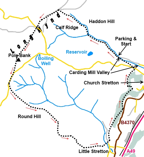
Introduction:
The Long Mynd is a heather covered ridge high above the town of Church
Stretton, rising to 1693 ft (517 metres) at Pole Bank. It is part of the
Shropshire Area of Outstanding Natural Beauty. Its name means Long Mountain
in Welsh. From its top are tremendous views stretching as far as the Brecon
Beacons (90 miles away) and the Malverns (43 miles away) on a clear day. It
has some of the best thermals in Europe so is popular for airborne
activities such as gliding, paragliding etc.
Along its summit runs The Portway, a track
used 5000 years ago by Neolithic traders to avoid the wet wooded valleys
below. This is now part of the Shropshire Way.
My Long Mynd walk starts from Carding Mill
Valley, at Church Stretton, a very popular spot with walkers, picnickers
and school parties alike. On the plus side, it is an exceptionally
pretty valley and there is plenty of parking, albeit of the pay and display
variety (National Trust). If possible, park just after the little bridge
over the stream when it switches from the left to right side of the road.
The return path will then deliver you exactly back to the car. Please note
that at peak times, even with the ample parking, it actually gets full!
The walk is not difficult. The initial ascent
is a moderate climb. Most of the last section is easy but there are one or
two sharp climbs and descents towards the end which might cause you to
curse!
Start:
From the parking
(SO 445944), walk up the road past the Chalet Pavilion, National
Trust office etc. As you get to the area designated for residents parking,
cross the stream via the bridge to avoid having to ford the stream a hundred
yards further on.
%20View%20up%20Carding%20Mill%20Valley.jpg)
Continue to walk along the valley, passing
the last rough car park. The path does split into two but they join up later
and the only difference is that the right hand one involves fording the
stream a couple of times.
At a three way fingerpost (SO 436951), fork
right for “Shooting Box 30 mins”. The broad stony path now climbs
steadily to the top of the Long Mynd. There are great views back down
Carding Mill Valley as you climb. This section of path is evidently known as
Motts Road, after a local doctor who improved it to make access to outlying
patients easier.
%20Looking%20back%20down%20Carding%20Mill%20Valley.jpg)
The path joins a broad track, more like a
road, The Portway, at a post indicating it is also part of the Shropshire
Way (SO 427958). Turn left heading towards Pole Bank, which a vertical sign
on the side of the post indicates is 1¼ miles away. To the left is Calf
Ridge and you soon pass a small tarn on the right.
%20Joining%20the%20Portway.jpg)
%20View%20SW%20along%20the%20Long%20Mynd.jpg)
%20View%20SE%20from%20Long%20Mynd.jpg)
After a quarter of a mile, you reach a marker
post (SO 424596) with many footpath arrows and a pink line round its top (an
indicator for one of the National Trust walks).You want the middle path
bearing slightly right off the main track, still part of the Shropshire Way.
You arrive at a car park with a post
indicating you have arrived at Shooting Box (SO 421953), though there is no
longer any sign of a shooting box. There is a Bronze Age burial mound.
Cross the road and continue straight ahead on
the Shropshire Way.
Not long before reaching Pole Bank and its
trig. point, you come to a crossroads of
tracks (SO 417956) and a marker post indicates a left turn will take you to
Boiling Well. It is about a quarter of a mile down this track, where it
meets the road. I was quite excited by the name “Boiling Well” on the
map so diverted for a look. Clearly someone had turned the gas off! A damp
patch of ground with a tiny trickle was all there was to see. To be fair, I
did this walk after a dry spell but frankly I would not bother unless
copious recent rains give you cause for optimism.
The descending path from Boiling Well takes
you down the valley bottom (Ashes Hollow) to Little Stretton, should you
want to shorten the walk but this misses out on superb views further on.
Back to the Shropshire Way, continue to Pole
Bank (SO 415944). Alongside the trig. point is an impressive orientation
table (described as a “Toposcope” on its plaque) which indicates the
main points of the 360° panorama. This was erected to mark the diamond
jubilee of the Council for the Protection of Rural England (CPRE) in 1986.
%20Pole%20Bank.jpg)
From the trig. point, continue straight ahead
,again, on the Shropshire Way.
Turn right at the road and pass the copse of
trees and a car park. Just past this, look out for a grassy path going off
to the left at about 30° (SO 413937). A short distance along this, join a
path coming from the road (which you can see) and turn left. If you missed
the 30° path, a marker post at the road here shows where you should turn
left.
You now approach Round Hill. A path goes over
its top but I took the left fork to follow the top of the Ashes Hollow
valley. In practice, the two paths meet up.
The path bends right then anti-clockwise
round another hill and leads down to Little Stretton. This section of path
round the hill has a truly lovely view.
%20View%20after%20passing%20Round%20Hill.jpg)
%20Approaching%20Little%20Stretton.jpg)
%20View%20towards%20Church%20Stretton.jpg)
Pass a pretty cottage which is also the
admin. for a small campsite (SO 440920) and cross the footbridge. Here I
surrendered to the lure of the Green Dragon pub and if you are similarly
inclined, after the footbridge, turn right and follow the road round to the
main road (B4370). Right again and the pub is but a few yards further on.
The continuation of the walk is straight
ahead at the above mentioned footbridge climbing a short steep bank.
The path follows the top of the valley
through the trees, initially looking down on the campsite. At the end of the
trees, cross a stile and keep straight ahead following the fenceline on the
right. The precise line of the path may be a little indistinct to stat with
but soon becomes clear.
The path starts to follow the line of a wood
on the right and eventually the wood spreads to both sides and the path
descends.
Follow the path just to the road (SO 446930)
then turn immediately left to climb once again on a bridleway with the wood
on the left and the rear of houses on the outskirts of Church Stretton on
the right.
The path comes out of the wood at some
bungalows (SO 448936). Next to the last bungalow, turn left to climb a long
flight of steps. A fingerpost indicates “Public Footpath to Townbrook
Hollow”.
At the top of all the steps, turn right to go
round the edge of trees, eventually descending quite steeply to a small
reservoir. Cross the footbridge and keep straight ahead climbing the path at
the other side of the little valley.
On reaching a road by a cattle grid, go
straight ahead across the road and left along the gently descending track.
If you have parked where I suggested, you will now be at your car.
If you need to buy any
hiking equipment/clothing before your trip see the Hiking
Store
All information on this
site is given in good faith and no liability is accepted in respect of any
damage, loss or injury which might result from acting on it.
|


.jpg)
.jpg)
.jpg)