
|
|
|
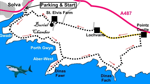
To view route as a dynamic Ordnance Survey map click here. Introduction: This circular walk from Solva explores some rugged coastal scenery on the Pembrokeshire coast, before turning inland and returning to Solva via an ancient burial chamber, which, unlike many similar notations on maps, is clear and unmistakable. The going is mostly straightforward but with a moderate climb out of Gwadn Bay. Solva is at attractive village at the head of an inlet flooded by the sea (a ria) which provides a natural protection from the ravages of the ocean. It was a major port during medieval times. Lime burning was also important and old lime kilns can be seen alongside the quay. At low tide, there is a beach by the mouth of the inlet. There are one or two craft type shops in the village and a couple of nice pubs. The furthest point of the walk is Pointz Castle. There is an overgrown motte and bailey here but I did not stop to try to identify them. Returning from here, the route passes through the tiny, attractive hamlet of Lochvane before arriving at St Elvis Farm (no Hound Dogs seen!). Here, there is a double-chambered Neolithic tomb with two large capstones. The site is reasonably well preserved, despite having suffered damage in 1890, when a farmer decided to give it the “benefit” of some explosives! The farm is named after St Elvis who died between 527-531 AD. The walk starts from the large car park by the harbour in Solva, off the A487, which runs through the village. Start: By the entrance to the car park in Solva, follow the fingerpost for the “Coast Path”, walking down the left hand side of the estuary as viewed from the car park. Cross a bridge over the stream then turn left following the fingerpost for “Newgale 5½ miles” and “Coast Path”. After a few yards, just to the right of a power pole, climb some steps, once more indicated by a Coast Path sign. Pass a three way fingerpost and ignore the path to the left. Just beyond here, some old lime kilns are passed. At SM 803240 ignore a path to the right and keep climbing.
Just beyond here is a three way fingerpost (SM 802239) but once more, keep straight ahead following the Acorn sign. Shortly after here is a good viewpoint (SM 802239) looking over the little Gwadn Bay with a large rock out at sea with the name St. Elvis Rock.
Drop down to cross the footbridge at the rear of Gwadn Bay and climb the path at the far side. This is the start of the National Trust land of St. Elvis Farm. Inland is a pretty valley with a ridge on the left which is climbed on the return. Along the coast is the Dinas Fawr peninsula.
You reach the prominent Dinas Fawr peninsular (SM814232). You can walk along a narrow path to the end of the peninsula but in places, this is not for those who suffer any vertigo problems! It was especially dramatic, with mist coming and going!
Go through a walkers’ gate (SM 824231) bearing a notice indicating you are at Dinas Fach. The main significance of this is that you need to be sure you are past this point before turning inland. The path turns inland not far past here at a steep narrow bay (SM 826230). Follow the path down to a small footbridge. Cross and turn left along a broad track.
Cross a second footbridge then take the first path on the right, soon passing a three way fingerpost. A short climb takes you to a walkers’ gate, through which you turn right and follow the right field boundary. Follow the field boundary as it bends left, arriving at a gate, next to a water trough, where you go through, to follow the public footpath fingerpost. In the next field, follow the left hand boundary and in the far left hand corner, go through a kissing gate and then turn left along a broad track. The track soon divides but ignore the left hand arm. At a tarmac lane, turn left along it (SM 830237). Follow the lane for half a mile to the tiny hamlet of Lochvane. Walk straight through it, staying on the broad track as it bends left but within a few yards, turn right through a walkers’ gate along a hedged footpath.
Follow this path through several gates and when it opens into a field, keep to the right hand boundary and also in the next field. Solva comes into view. At the end of the second field, join a broad track to St. Elvis Farm. Here, turn left before the farm buildings through a walkers’ gate. After a hundred yards or so, turn right to follow the fingerpost for “Solva 1 Mile”. Just in front of you are the large stones of the burial chamber, in a fenced enclosure. There is a gate so you can get a close inspection. The onward route is to the right of the burial chamber (as you approach).
Continue along the broad track, heading for the bottom right hand corner of the field to a kissing gate. Go through this and follow the fingerpost for “Solva”. At SM 810241 there is a short fingerpost, somewhat hidden in the foliage. Fork right here to follow the sign for “Solva”. At the sewerage treatment works, the path forks. Keep right. The path forks again within a few yards. This time, keep left. The path climbs quite steeply to a kissing gate, overlooking Solva. Follow the path round to the right. It then descends the other side of the ridge. When it joins another path, turn left to return to the car park. If you need to buy any hiking equipment/clothing before your trip see the Hiking Store All information on this site is given in good faith and no liability is accepted in respect of any damage, loss or injury which might result from acting on it.
| | |||||||||||||||||

.jpg)
.jpg)
.jpg)
%20View%20over%20Solva%20harbour.jpg)
%20Gwadn%20Bay.jpg)
%20Beach%20at%20Gwadn%20Bay.jpg)
%20View%20inland%20from%20newr%20Gwadn%20bay.jpg)
%20View%20to%20Dinas%20Fawr%20peninsula.jpg)
%20Entrance%20to%20Solva%20Harbour.jpg)
%20View%20over%20Porth%20Gwyn%20and%20Porth%20y%20Bwch%20beaches.jpg)
%20Looking%20along%20the%20Dinas%20Fawr%20peninsula.jpg)
%20Looking%20east%20from%20the%20end%20of%20the%20Dinas%20Fawr%20peninsula.jpg)
%20View%20to%20Solva%20from%20the%20Dinas%20Fawr%20peninsula.jpg)
%20Same%20view.jpg)
%20Dinas%20fach.jpg)
%20Lochvane.jpg)
%20Burial%20chamber.jpg)