|
Porthclais
and Whitesands Bay
|
Starting
point and OS Grid reference:

Car
Park at Porthclais (SM739242)
|
Ordnance
Survey Map
OL35
– North Pembrokeshire.
Buy this map from
List
of OS Maps
Commission from map sales is
used to fund the website, so keeping it free to use.
| |
Distance: 7
miles
| |
Traffic light rating: 
(For explanation see My
Walks page)
| |


For advice on .gpx files see
My
Walks page
|

Click
the PDF logo above to give a printable version of this walk without the
photos.
|
To
view route as a dynamic Ordnance Survey map click here.
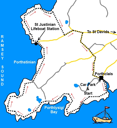
Introduction:
Porthclais is a small harbour set in
an inlet not far from St David’s. It is reputed to have been built in the
12th century as the port for St Davids. The walk takes in an
attractive stretch of coastline with some interesting rock arches. There are
old limekilns at the harbour. The walk takes in the St Davids St Justinians
lifeboat station at Porthstinian Harbour and the remains of St Justinian’s
Chapel. You pass “The Bitches”, a number of rocks in Ramsey Sound
between Ramsey Island and the mainland where the swirling currents are
obvious and just touch the end of the beach at Whitesands Bay.
This very easy straightforward walk starts
from either of the adjacent two car parks at Porthclais. One belongs to the
National Trust (so free if you are a member) and it has a kiosk serving
refreshments. There is some road walking but the roads are very quiet and
you will meet little if any traffic.
To get to Porthclais, head south-west out of
St Davids and follow the signs.
%20Harbour%20at%20Porthclais.jpg)
Start:
Turn left out of either car park (SM739242) and after inspecting the harbour,
follow the coastal path immediately to the right of the harbour (as viewed
from the road) indicated by the acorn sign. It is then simply a case of
following the coast path to Whitesands bay. There are good views of Ramsey
Island.
%20Looking%20East%20Near%20Porthclais.jpg)
%20Looking%20West%20Near%20Porthclais.jpg)
%20Window%20on%20the%20Sea.jpg)
As you get to the area above the lifeboat
station at Porthstinian Harbour (SM
723252), behind the wooden hut are the remains of St. Justinian’s Chapel
viewable from the road only unfortunately as it is on private land.
%20St%20Davids%20Lifeboathouse.jpg)
%20St%20justinians%20Chapel.jpg)
The footpath passes between the small wooden
hut and the top of the goods delivery “mountain railway” servicing the
lifeboat station.
Continue on the coast path to Whitesands Bay
passing and ignoring a stile clearly marked as private, going to a campsite.
%20Whitesands%20Bay.jpg)
Follow the bay round beneath the campsite and
turn right away from the coast over a small stone “bridge” – actually
a single slab (SM 727260). Walk up the path ignoring a footpath to the left
past a large stone gatepost.
Your path joins a track marked “Private”
to the left so obviously you turn right and at the next broad track which is
the entrance to Pencarnan Caravan site, turn left.
On reaching the road (SM 730254), turn left
and follow it round the bend until you come to a road junction on the right
with no sign showing its destination (SM
735254). Turn right here. The map indicated there is a lake Pwll Trefeddan
here on the right but it was dried up when I passed.
At a crossroads, go straight ahead signed for
Porthclais and follow the road to your starting point.
If you need to buy any hiking
equipment/clothing before your trip see the Hiking
Store
All information on this
site is given in good faith and no liability is accepted in respect of any
damage, loss or injury which might result from acting on it.
|


.jpg)
.jpg)
.jpg)