|
Lathkill
Dale
Starting point and OS Grid reference:

Free
roadside parking at SK 193645.
|
Ordnance Survey Map
OL24
The Peak District - White Peak area.
Buy this map from
List
of OS Maps
Commission from map sales is
used to fund the website, so keeping it free to use.
| |
Distance: 6.9
miles
|
Date of Walk: 24 April 2015
| |
Ascent:
Descent:
See Walking Time Calculator
|
1185ft (361m)
1184ft (361m)
| |
Traffic
light rating: 
(For explanation see My
Walks page)
| |


For advice on .gpx files see
My Walks page
|

Click
the PDF logo above to give a printable version of this walk without the
photos.
|
To
view route as a dynamic Ordnance Survey map click
here.
Introduction: Lathkill Dale is one of
the country’s finest limestone valleys and a haven for flora and fauna.
Along it runs the crystal clear River Lathkill. It derives its name from the
Norse Hlatha-gyll, meaning “barn in a narrow valley”. In addition to
farming, the valley has in its time seen much industrial action by millers,
quarrymen and lead miners and remnants can be seen, not least the
interesting Bateman’s House.
The valley is dry until you get to Lathgill
House Cave, then the dale widens out and the river begins to grow.
The valley contains an area enclosed to
protect the rare Jacob’s Ladder flower, so rare that it is listed in the
British Red Data Book of plants. It derives its name from the shape of its
leaves which resemble a ladder (if you stretch your imagination a little!).
In the spring, you might see wild orchids.
This is a popular walk and you are unlikely
to have it to yourself but spread out along its length, numbers are not too
bad.
There are no facilities en route but plenty
of rocks which can be put to use as picnic stops.
The walk starts from a free rough parking
area at the junction of Back Lane and Moor lane outside Youlgrave, about a
mile from Youlgrave (or Youlgreave - so good they named it twice!) (This
avoids a pricey pay and display at Over Haddon!). To get there, turn NE off
the A515 at Parsley Hay, signposted for Youlgreave and Monyash. After 250
yards, take the first right, signed
for Youlgreave and Lathkill Dale and follow this lane for 2¾ miles
to the parking area It is signposted with ‘P’ signs at Moor Lane.
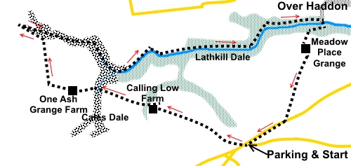
Start: Cross the road from the parking
(SK 193645) and go through a walkers’ gate following a fingerpost for the
“Limestone Way”.
There is an easy to follow path through/over
a series of stiles and gates and through Low Moor Wood.
By Calling Low Farm (SK 181650), go through a
kissing gate, following a public footpath fingerpost, then through another
two small woods. As you emerge from the second wood, head towards the right
hand field boundary about a hundred yards down the field. You start to get
glimpses of Lathkill Dale below, to the right. Go through a kissing gate to
follow the fingerpost for “Cales Dale”.
%20Looking%20down%20Cales%20Dale%20to%20Lathkill%20Dale.jpg)
Follow the path through another couple of
kissing gates. You enter the Lathkill Dale National Nature Reserve and
descend a long flight of stone steps into Cales Dale (SK 173653).
At the bottom of the steps, go over a stile.
There is a four way fingerpost. Follow the climbing path in the direction of
“One Ash Grange”. Alternatively, if you want to shorten the walk, turn
right along Cales dale to follow the fingerpost for Lathkill Dale, although
this misses out some of the more dramatic sections, where it is most gorge
like.
When you arrive at a farm (confusingly signed
as Health House Farm when I visited), the path goes to the left of the
corrugated iron barn, up some steps. Follow the main track through the farm
and turn right at a three way fingerpost for “Monyash” SK 166653).
Further along the track, another fingerpost
confirms the direction to “Monyash”.
Arrive at a fingerpost by a gate and follow
“Lathkill Dale.
Keep straight ahead at a copse of trees.
At a pair of gates, follow the direction of
the yellow arrow, through the left gate.
Go through a kissing gate in the next field
and bear slightly left to the wall at the bottom and follow it along, left.
Note if you look over the wall, you might see what looks like another path
but do not be misled. Stay to the left of the wall.
The route descends gently to a stone step
stile (SK 162661). Cross this and turn sharp right. You are now in Lathkill
Dale and all you need to do is follow the main path along the valley bottom.
%20Earlt%20section%20of%20Lathkill%20Dale.jpg)
%20Lathkill%20Dale.jpg)
At SK 167660, you pass an enclosed area with
a sign informing you that it contains prolific amounts of the rare plant
Jacobs Ladder. This is usually in flower from late May to late June.
At SK 171659 you pass the entrance to a cave
and not far after this, the river Lathkill starts to make its presence more
noticeable. Continue to follow this, ignoring any side turns.
%20Cave%20in%20Lathkill%20Dale.jpg)
%20Cliffs%20in%20Lathkill%20Dale.jpg)
You pass a footbridge which is the direct
route from Cales Dale.
You pass a pleasant waterfall.
%20Lathkill%20Dale%20waterfall.jpg)
There are some old millstones further along
and remains of an old sluice gate, weir and dam (SK 184658). These are the
remnants of Carter’s Mill.
%20Old%20millstones.jpg)
%20Mill%20Dam.jpg)
At SK 194659 there is a footbridge leading to
a ruined building. This is Bateman’s House and hides a secret in that it
is built over a mineshaft. Furthermore, you can descend some steps at the
rear for a closer look. It is quite safe and there are information panels
which tell you about the history and about an unusual water pump which kept
the mine dry. There is a hand operated generator to light the shaft but you
really need two people to alternate between cranking and viewing.
%20Peering%20into%20mineshaft%20at%20Batemans%20House.jpg)
Continuing the walk, you pass stone pillars
which once carried an aqueduct to operate a waterwheel.
Continue to follow the river along until you
reach a large panel just before a barn, with information about Lathkill
Dale. Turn right past the barn and cross the river via the stone clapper
bridge (SK 203661).
%20Clapper%20bridge.jpg)
On the other side, turn left along the broad
track, which soon turns back on itself, continuing to climb out of Lathkill
Dale.
Arrive at a gate (SK201660). Follow the
fingerpost which indicates the Right of Way through the farm (Meadow Place
Grange).
At the farm, go straight through the farmyard
to follow the fingerpost for “Youlgrave” and “Middleton”. When the
path splits, take the right fork and follow the wall on the right until it
turns right at a corner. Here is a yellow arrow indicates the onward
direction, more or less at 45° to the route from the farmyard. This 45°
course is now virtually a straight line to the road by which you are parked,
about a third of a mile further on.
Head for the right hand boundary of the field
where there is a stile about half way along. Over this, head for the
diagonally opposite left corner of the next field, where there is another
stile. Cross and continue in the same direction, following the fingerpost.
Just short of the diagonally opposite corner,
cross another stile into the road. Turn right to follow the road back to the
parking area.
If you need to buy any
hiking equipment/clothing before your trip see the Hiking
Store
All information on this
site is given in good faith and no liability is accepted in respect of any
damage, loss or injury which might result from acting on it.
|


.jpg)
.jpg)
.jpg)