
|
|
|
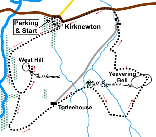
To view route as a dynamic Ordnance Survey map click here. Introduction: Yeavering Bell is an interesting hill, 1182ft high. Interesting, in view of its history and the fantastic views it offers, not least to The Cheviot. It has a double summit which is encircled by a prominent stone band, the remains of an ancient and, judging from the amount of stone, what must have been a substantial wall, encircling a settlement. It has been estimated as having been 2½ metres high. It is the largest of such Iron Age settlements in Northumberland. Remains of over a hundred roundhouses have been found here. The eastern summit is marked by the remains of a Neolithic burial cairn. Yeavering Bell is also home to some now wild goats, brought to Britain in Neolithic times from the Middle East. I was lucky enough to see some, with huge horns, though thankfully docile enough. West Hill, which you visit first, also has the remains of an Iron Age settlement. Although not as clearly defined as the one on Yeavering Bell is, by its wall, the remains of the earthworks and some stonework are nevertheless clearly visible. The walk is straightforward enough with only moderately steep ascents and descents and so earns amber “traffic lights”. The walk starts from the car park adjacent to the village hall in Kirknewton, which is on the B6351 around 23/4 miles west of the A697 (near Wooler). The village hall is opposite the church. Start: Leave the car park (NT 914302), turning left along the tarmac lane, following it round as it bends left, then right in the direction of white arrows. The tarmac gives way to a stony track. Stay on this track, ignoring a path off to the left (NT 911299).
Continue to follow the track as it curves anti-clockwise round West Hill. Look out for a post bearing multiple footpath arrows and a fingerpost to the right of the track, indicating a permissive footpath (NT 909291). This is the ongoing route to Yeavering Bell but first visit West Hill summit.
A mere forty or fifty yards past the post/fingerpost, look out for a faint footpath climbing the hill to the left. Climb this path. Eventually it becomes virtually invisible, at which point, all you need to do is bear left to the summit. You will soon pass through the remnants of the outer defences of an ancient Iron Age fort.
From West Hill summit, return to the permissive path fingerpost. From here, follow the permissive path the short distance to the ladder stile. Cross it and head slightly right, following a yellow footpath arrow. Look out for a walkers’ gate about half way along the wall, at the side of the field opposite to the ladder stile. Through the gate, the path is straight ahead for fifty yards or so before bending right. Join a more distinctive path at some gorse bushes where you turn left. Follow the path to the end of the first group of gorse bushes, then turn left again, climbing slightly. The path soon goes left, heading to the right of a stone sheep pen. You are now on St Cuthbert’s Way, a broad obvious track which you follow. The track passes through a plantation before arriving at Torleehouse. Just before the house, turn right to follow the St. Cuthbert’s Way sign (this is a diversion from the path shown on the OS map which goes straight past the farm on the main track). Initially, this runs parallel with the main track you have just left but after passing Torleehouse, gradually peels away to the right. Follow the contour level across the field to a gate at the far side. The track beyond is clear.
The track forks just before a plantation. Take the right fork, climbing and curving right. Cross a ladder stile and turn right, continuing to follow St. Cuthbert’s Way/Hill Fort Way. Look out for another ladder stile on the right, which is your indicator to turn left and follow a narrower footpath through the heather downhill, into the little valley (NT 923288).
Cross a stream and climb the other side. The path to the summit of Yeavering Bell is obvious. Note as you climb that Yeavering Bell actually has two summits. This is important as it will help you find the descent path. As you climb, there are great views behind to The Cheviot. You pass through a broad band of stones which appear to encircle the summits.
Head initially to the right hand summit where the remains of a burial cairn mark the top. Views back to The Cheviot are tremendous.
To find the descent path, head downhill to the “valley” between the summits and at the bottom of it, turn right. Pass through the broad stone band again at NT 928294. Here you will find a post with a white arrow. Follow its direction.
If you need to buy any hiking equipment/clothing before your trip see the Hiking Store All information on this site is given in good faith and no liability is accepted in respect of any damage, loss or injury which might result from acting on it.
| | |||||||||||||||||

.jpg)
.jpg)
.jpg)
%20View%20over%20Kirknewton.jpg)
%20View%20up%20the%20valley%20of%20College%20Burn.jpg)
%20Summit%20of%20West%20Hill.jpg)
%20View%20North%20from%20West%20Hill.jpg)
%20Yeavering%20Bell.jpg)
%20Approaching%20Yeavering%20Bell.jpg)
%20Wild%20goat%20on%20Yeavering%20Bell.jpg)
%20Part%20of%20stone%20band%20on%20Yavering%20Bell.jpg)
%20View%20to%20the%20Cheviot.jpg)
%20Summit%20of%20Yeavering%20Bell.jpg)
%20Cheviot%20from%20summit%20of%20Yeavering%20Bell.jpg)
%20Northern%20edge%20of%20Yeavering%20Bell%20with%20stone%20band.jpg)