|
Scar House Reservoir to Little Whernside and Angram Reservoir
|
Starting
point and OS Grid reference:

Extensive
free car parking at Scar House Reservoir (SE
068766)
|
Ordnance
Survey Map
Yorkshire
Dales Northern and Central Areas OL30.
Buy this map from
List
of OS Maps
Commission from map sales is
used to fund the website, so keeping it free to use.
| |
Distance: 9.8
miles
| |
Traffic light rating:


(For explanation see My
Walks page)
| |


For advice on .gpx files see
My
Walks page
|

Click
the PDF logo above to give a printable version of this walk without the
photos.
|
To
view route as a dynamic Ordnance Survey map click here.
Introduction:
Yorkshire is blessed with three Whernsides. There is “Whernside”
736 metres (2415ft) high and one of the “Three Peaks”. There is
Great Whernside which by some quirk of Yorkshire logic is lower at 704
metres (2310ft) and finally we have Little Whernside at 604m (1,981 feet).
Poor Little Whernside is somewhat forgotten and this walk was an attempt to
rectify that. It is in effect a continuation of the Great Whernside broad
ridge but most people climb Great Whernside from Kettlewell and they never
get as far as Little Whernside before descending again.
This walk runs along one shore of each of
Scar House and Angram Reservoirs, filled by the river Nidd built to supply
the Bradford area, with the ascent of Little Whernside in between. From its
summit there are extensive views along Coverdale to the north and Nidderdale
to the south east although they were rubbish on the day I recorded this
walk! Conditions were **** (add your own expletive!). This was a shame
because there would normally be great. Just one of those things.
There are “groughs” (peaty gullies) and
the walk can be very boggy so gaiters are recommended. Some of the bog can
be quite deep so be careful where you walk. Walking poles are useful for
probing!
There is extensive parking at Scar House
Reservoir where the walk starts. However it is not the easiest of places to
find. Turn off the B6265 by the river bridge in Pateley Bridge, signposted
for Ramsgill, Lofthouse and Middlesmoor. Continue along this road past the
expanse of Gouthwaite Reservoir and Ramsgill until you reach a right turn
signposted with a small road sign for Masham 10 miles. It is easy to miss
this turn but some blue warning signs saying Unsuitable for Goods Vehicles
and Buses also indicate it. Do not turn on to this road
- the turn into the reservoir road is immediately after this turn on the
right. It is quite a long road in - about 3/4 miles. Park as close to the
dam as you can. There are information/picnic tables/toilets etc.
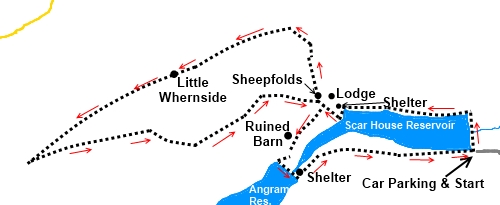
Start:
Start at the Scar House Reservoir car park (SE 068766).
Cross the magnificent stone built dam and turn left along the path
closest to the north shore of Scar House reservoir. As the reservoir
narrows, pass a very nice shelter with bench seating at SE050771. Shortly
after this, go through a gateway and turn right following a wall on the
right (SE050771). There is a signpost for Angram Reservoir.
%20Wintry%20view%20over%20Scar%20House%20Reservoir.jpg)
%20Angram%20Reservoir%20Dam.jpg)
On reaching a series of gates which form
sheepfolds, continue through them, following the line of the wall straight
ahead. Note the sheepfolds as they mark a junction on your return. The path
becomes a walled lane for a short distance. At the junction with another
track to the right, ignore this and keep straight ahead. Go through a gate
on to the open fell and continue to climb the rough track with the wall on
your right. The path swings round to the left and the flat plateau of Little
Whernside becomes obvious.
%20Approach%20to%20Little%20Whernside.jpg)
You arrive at the flat ridge by a gateway (SE
044782) where there is a fingerpost for Braidley. Do
not go through it but turn left and follow the fence line on your
right climbing towards Little Whernside. The fence becomes a wall. Continue
to follow this line of ascent, eventually going through a walkers gate.
There is little to mark the boggy summit (SE
028776), other than the remains of a stone cairn which you might miss, but
as you progress along the line of the wall the ground begins to fall gently
away to the saddle between Little Whernside and the Great Whernside/Black
Dike End ridge. As you descend you will see a path coming towards you but
bearing away to your left at an angle. Join this path turning left to head
downhill back towards the reservoirs.
The path is quite faint in places but stay on
it and ignore a broad track to the right. Shortly after this broad track, go
through a gate.
Cross another wall at a ruined gateway then
two more walls. When you arrive back at the sheepfolds, turn right down to
the broad track running parallel with the water and turn right to Angram
Reservoir.
If you lose the route of the path you can
descend at virtually any point between the two reservoirs to the broad track
mentioned above, although the rough ground can make it hard work. Look out
for a ruined barn (SE 043767). The broad track is just over 100 yards below
it.
%20West%20End%20of%20Scar%20House%20Reservoir.jpg)
%20Closer%20view%20of%20Angram%20Reservoir%20Dam.jpg)
%20One%20of%20the%20shelters.jpg)
%20Inside%20shelter.jpg)
Cross Angram dam and turn left following the
direction of the fingerpost for Scar House Circular. Pass another shelter
(SE 045763). Follow the broad tarmac track back to the car park.
If you need to buy any
hiking equipment/clothing before your trip see the Hiking
Store
All information on this
site is given in good faith and no liability is accepted in respect of any
damage, loss or injury which might result from acting on it.
|


.jpg)
.jpg)
.jpg)